Una (Sava)
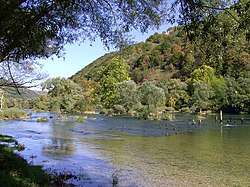
The Una (pronounced [ûna]; Cyrillic: Уна) is a border river between Bosnia and Herzegovina and Croatia and a right tributary of the Sava river.[1] It is part of the Black Sea drainage basin, and its watershed has a size of 10.200 km², of which 8.080 km² belongs to Bosnia and Herzegovina, and 2.120 km² to Croatia. The total length of the river is 212 km.[2] The source of the river is located in the town of Donja Suvaja in Croatia, and its mouth is located near the town of Jasenovac, on the border with Bosnia. The largest right tributaries are the Krka, Unac, Krušnica and Sana rivers, and the largest left tributary is the Klokot river. Its longest headwater is the Unac river. The largest and most important city located on the river is Bihać. Other, smaller cities and towns are Bosanska Krupa, Novi Grad and Kostajnica. The river is characterized by a multitude of waterfalls, rapids, karst springs and relatively untouched nature. A large part of the upper river is part of the Una National Park.
| Una | |
|---|---|
 Una below Ostrožac Castle, downstream of Bihać | |
| Location | |
| Countries | |
| Physical characteristics | |
| Source | |
| • location | Donja Suvaja, Croatia |
| Mouth | |
• location | Jasenovac, Croatia |
• coordinates | 45.270°N 16.918°E |
| Length | 212 km (132 mi) |
| Basin size | 10,200 km2 (3,900 sq mi) |
| Discharge | |
| • average | 240.3 m3/s (8,490 cu ft/s) |
| Basin features | |
| Progression | Sava→ Danube→ Black Sea |
Etymology
According to local legends, the river was named by the Romans who, after seeing it for the first time, said una (lat. one, as a reference to its unique beauty) to describe it.[3]
Una is a popular female name even in the areas that are not located in the vicinity of the river. One explanation for this is that people that were displaced during the Yugoslav Wars continued to give the name to their children.
Geography
Source
The source of the river Una is a karst spring located in the town of Donja Suvaja, Croatia at an elevation of 358,850 m above sea level. The water, originating from great depths, forms a round, calm bluish green lake, 30 m by 15 m in size. It is surrounded by forests and steep cliffs of the Lička Plješevica and Stražbenica mountains.[4]
The karst aquifer of the Una is located mostly in the territory of Croatia. The aquifer itself takes up a large area from Korana in the northwest to Velika Popina in the southeast. It encompasses the mountainous areas of the Lička Plješevica, Čemernica and Mala Kapela mountains, and the Koreničko, Bijelopolje, Krbavsko and Lapačko karst fields. All aforementioned karst fields are directly connected to spring of the river itself, and other nearby springs (Klokot, Vedro Polje, Dobrenica, Ostrovica).[5]
The hydrological parameters of the river are regularly monitored around 500 m from the spring itself, which provides data about the parameters of the spring, but one must take into consideration the fact that the water temperature can be influenced by the surrounding air temperature in those 500 m when analyzing the data. The discharge of the spring varies from a minimal 0,076 m3/s, recorded in 1987. to a maximal 98,1 m3/s, recorded in 2009., with the average discharge being 7,21 m3/s. The temperature of the water varies in relatively narrow margins between 8 °C and 11 °C, with an average of 9,5 °C, which leads to the conclusion that the water that surfaces spends a large amount of time in the karst underground. One interesting thing to note is the fact that the average discharge seemed to increase in the period of 1998 – 2016 during the wet periods of the year compared to the period of 1972 – 1998, and decrease in the dry periods of the year. This could lead to the conclusion that there was a change in the hydrological regime of the spring, but further data and analysis is required for a definite conclusion. There could also be a trend of rising water temperature, but more concrete evidence is also required to prove it.[4]
Upper Course
The upper part of the river spans from its source to the city of Bihać.
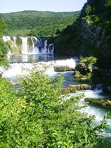
After emerging from its source, the river flows for about 5 km before reaching its confluence with the Krka river, after which it forms the border between Bosnia and Croatia. It forms the border for about 7,5 km and then enters Bosnia completely for the first time and enters the national park, flowing through the village of Martin Brod, where it forms a cascade of waterfalls with the total drop being about 54 m. Downstream of Martin Bord, the confluence of the Una and Unac is located, where the river more than doubles in size. After 9 km the river takes a sharp turn westwards and enters the town of Kulen Vakuf where the confluence with the small tributary Ostrovica is located. After exiting Kulen Vakuf, the river takes a sharp turn northwards and continues to flow in its general northward direction. Downstream of Kulen Vakuf, the river flows for about 8.5 km, meandering through a valley and passing by the village of Klisa before forming the border with Croatia for the second time. This time, the river forms the border for about 18 km and cuts through a gorge, forming a cascade of rapids and waterfalls, the biggest and most notable being the Štrbački buk. After entering Bosnia completely for the second time, the rivers forms the Troslap and Dvoslap waterfalls, after which it exits the national park and flows through the villages of Lohovo and Račić. After that, the river slowly enters the Bihać field, flowing through the villages of Ripač, Golubić and Pritoka, taking in the waters of the Dobrenica and forming multiple river islands and small waterfalls, before finally entering the city of Bihać after about 66,5 km of total flow. In Bihać, the river forms multiple islands of varying sizes, often surrounded by small waterfalls, some of which are private property while others are public and often popular bathing sites. The core of the city itself is surrounded by the Una river, and a channel carrying water from the river to a small hydroelectric power plant. Another small tributary of the Una, the Drobinica, flows through the city in a regulated channel before merging with the Una. In its upper course, the Una is a youthful river with a steep gradient of 0,232 % and a large amount of waterfalls. The total drop is 154 m over a distance of 66,5 km. The deposition of carbonate minerals and the formation of porous limestone rock (tufa) and pronounced karst influence is characteristic for this section.[2]
Middle course
The middle section of the river spans from the city of Bihać to the town of Novi Grad and its confluence with the Sana.
Not long after exiting the city the river takes in the waters from the short Klokot river, after which it meanders, slowly turning eastward before entering the village of Pokoj where it takes a sharp turn north and enters a canyon between Bihać and Bosanska Krupa where it slowly turns eastward again. The Una Kostela hydroelectric power plant is located not long after the entrance into the canyon and is currently one of two hydroelectric power stations on the main course of the river, the other being the small Bihać power plant. The canyon is, on average, around 150 m deep with lush vegetation growing on its cliffs. A road that connects Bihać and Bosanska Krupa follows the river through the canyon. After flowing for about 27 km through it, the river exits the canyon and enters the town of Bosanska Krupa where it takes a turn north. Like in Bihać, the river forms multiple islands surrounded by small waterfalls. Downstream of Bosanska Krupa, the river takes in the waters of the short Krušnica river before heading north towards the town of Bosanska Otoka, after which it forms the Inter-Entity Boundary Line and shortly after forms the border with Croatia for the last time, and remains a border river until its mouth. Not long after becoming the border, the river enters the town of Novi Grad, where the confluence with the Sana river is located. The Sana is the longest and most significant tributary of the Una and greatly increases the discharge of the river. Waterfalls and tufa are rarer in this section, albeit still present. The confluence with the Sana marks the end of the middle section of the river and the beginning of the lower section. The total length of the river between Bihać and Novi Grad is around 103 km. The gradient is 0,067 %, with a drop of 69,5 m over a distance of 103 km.[2]
Lower course
The lower section of the river spans from the town of Novi Grad to the river mouth.
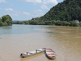
After exiting the town of Novi Grad, the river flows in a general northeast direction until its confluence with the Sava river near Jasenovac. Major towns and villages on the river in this section are Novi Grad, Kostajnica and Kozarska Dubica on the right bank in Bosnia and Dvor na Uni, Hrvatska Kostajnica and Hrvatska Dubica on the left bank in Croatia. The waterfalls, rapids and tufa rock that were common in previous sections are almost completely nonexistent in the lower section as the Una takes up the characteristics of a mature river, meandering through alluvial plains and having a low gradient. Near its confluence with the Sava exist a couple of oxbow lakes colloquially called Stara Una (lit. "Old Una"). After a total length of about 212 km, the Una flows into the Sava river near the Croatian town of Jasenovac. The total length of the river between Novi Grad and Jasenovac is around 72 km. The gradient is 0,041 %, with a drop of 29,6 m over a distance of 72 km.[2]
Hydrography
Watershed
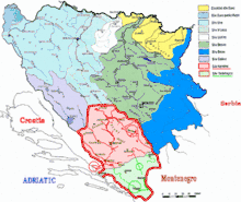
The watershed of the Una river has a total area of 10.200 km2, of which 79% (8.080 km2) belongs to Bosnia and Herzegovina, and 21% (2.120 km2) belongs to Croatia. It borders the watersheds of the Korana, Glina and Sunja to the northwest, the Adriatic watersheds of the Lika, Zrmanja and Cetina to the southwest, the watershed of the Cetina to the south and the watersheds of the Vrbas and Jablanica to the east. The shape of the watershed itself is very irregular, but if one had to approximate its shape with the shape of a geometric figure, a triangle would be the most fitting. Due to strong karst influence in the area, the watershed is poorly developed with few large surface streams. The karstification coefficient for the entire watershed is 0,244, which means that 24,4% of the surface area in the watershed lacks proper surface streams and drainage. The karstification coefficient up to Bihać is 0,43, up to Novi Grad 0,28 and up to Kostajnica 0,26.[2] The average air temperature in the area of the watershed is 10,5 °C, and the average amount of rainfall is 1133l l/m2[6]
The watersheds of the Una and the watersheds of the Korana and Glina are often grouped together for analytical purposes in Bosnia and Herzegovina.[7]
Discharge
The Una river has an average discharge of 240,3 m3/s at its mouth, with a minimal discharge of 40,95 m3/s.[2] There are relatively small differences in the average monthly discharges (the driest month August has 37% of average yearly discharge while the wettest month April has 155%) and minimal daily and monthly discharges also show a very small difference. Low discharges last a relatively long time and high discharges appear quickly due to sudden rainfall and snowmelt and last a comparatively short amount of time.[1] High discharges and water levels are present in April and December, and low discharges in August and January.[2]
There are multiple measuring stations in Bosnia and Herzegovina on the Una, and their data is show in the table below:[2]
| Measuring station | Average discharge (m3/s) | Watershed area (km2) |
|---|---|---|
| Martin Brod upstream | 21,0 | 790 |
| Martin Brod downstream | 51,6 | 1.950 |
| Kulen Vakuf | 53,2 | 2.028 |
| Štrbački buk | 65,0 | 2.586 |
| Bihać | 85,60 | 3.496 |
| Kralje - Bihać | 100,2 | 3.631 |
| Bosanska Krupa | 112,7 | 4.092 |
| Bosanska Otoka | 122,0 | 4.460 |
| Entity line | 124,4 | 4.540 |
| Country border | 126,2 | 4.611 |
| Novi Grad upstream | 131,6 | 4.798 |
| Novi Grad downstream | 218,5 | 8.997 |
| Kostajnica | 232,0 | 9.664 |
| Dubica | 238,0 | 10.024 |
| Mouth | 240,3 | 10.200 |
Tributaries
The Una river has a relatively weakly developed network of tributaries, owing to its karst geology. Most of the tributaries are shorter rivers, albeit with strong sources and relatively large discharges. There is also a number of karst springs located directly at the main channel of the river. The right tributaries of the river are the Krka, Unac, Krušnica, Vojskova and Sana rivers, and the left tributaries are the Dobrenica, Drobinica, Klokot and Baštra rivers.[2]
Sana

The Sana river is the longest and most important tributary of the Una river, with a watershed size of 4,189 km2. Its source is located under Lisina mountain, 420 m above sea level and has an average discharge of over 8 m3/s. The longest headwater of the Sana is the Korana, whose source, Dobra Voda, is located at an elevation of 870 m above sea level, but is relatively insignificant in terms of discharge (1m3/s) when compared to the main source of the Sana river. The mouth of the Sana is located in Novi Grad, at an elevation of 117 m above sea level. The Sana has a high karstification coefficient of 0,43 at the Ključ measuring station, which has the consequence of the Sana watershed being relatively undeveloped and having few surface streams. The tributaries of the Sana river are the Banjica (53 km2 watershed area), Gomjenica (776 km2 ). Kozica (120 km2), Ribnik (447 km2 ), Sanica (468 km2), Kijevska rijeka (64 km2), Dabar (111 km2), Zdena (65 km2), Blija (133 km2), Majdanuša (60 km2) and Japra (355 km2).[2]
The Sana flows through both entities of Bosnia and Herzegovina. Its source is located in Republika Srpska, after which it crosses the entity line and enters the Una - Sana Canton where it flows through Ključ and Sanski Most. After exiting Sanski Most, it crosses the entity line again and takes a sharp left turn at the foot of the Kozara mountain, after which it enters Prijedor and continues to flows towards its confluence with the Una in Novi Grad. The major cities and towns located on the banks of the river are Prijedor, Sanski Most and Ključ.
There are multiple measuring stations in Bosnia and Herzegovina on the Sana, and their data is show in the table below:[2]
| Measuring station | Average discharge (m3/s) | Watershed area (km2) |
|---|---|---|
| Donja Pecka RS | 9,3 | 447 |
| Entity line | 32,1 | 1.117 |
| Ključ | 33,2 | 1.149 |
| Vrhpolje | 43,0 | 1.153 |
| Sanski Most | 66,7 | 2.295 |
| Entity line | 72,0 | 2.261 |
| Prijedor | 81,4 | 3.509 |
| Novi Grad | 86,6 | 4.189 |
Unac

The Unac river is the longest headwater of the Una, and, at their confluence, has a larger discharge and a larger watershed. The longest headwater of the Unac, Šatorski potok, flows out of Šator lake under the Šator mountain at an elevation of 1.460 m above sea level.[2] The largest town on the Unac is Drvar, through which the river is regulated. The river is 66 km long and, throughout its course, flows through multiple gorges and canyons, the deepest one lying between Crno vrelo and Bereka in the National Park itself. It is 350 m deep and noted for its hydromorphological, geological, hydrological characteristics and its biodiversity. Throughout its course there is pronounced karst influence, and the river is partially disappears as a losing stream in part of its course, only to reappear at Crno vrelo, a couple of kilometers before its mouth.[8][9]
There are multiple measuring stations in Bosnia and Herzegovina on the Unac, and their data is show in the table below:[2]
| Measuring station | Average discharge (m3/s) | Watershed area (km2) |
|---|---|---|
| Drvar | 7,7 | 359 |
| Rmanj Manastir | 30,5 | 1.161 |
Klokot
The Klokot is a short river with watershed area of about 94 km2 and a length of 4,5 km. It flows out of a very strong karst spring around 5 – 6 km west of Bihać and has an average discharge of 14 – 15 m3/s.[2]
Krka
The Krka is a right tributary of the Una, and, for the entirety of its length, forms the border between Bosnia and Croatia. It's 4 km long and forms a small canyon. It has a watershed area of 119 km2 and is part of the Una National Park.[2]
Krušnica
The Krušnica is a right tributary of the Una. Its source, a strong karst spring with an average discharge of 7 – 8 m3/s, is located 6 km south of Bosanska Krupa. It is around 7 km long and has a watershed area of 301 km2. One interesting thing to note about the river itself is the fact that a small branch of the Una river flows into the Krušnica first, before the Krušnica flows into the Una.[2] A small hydroelectric power plant is also located near the river source.[10]
Economy
Hydropower
Due to the rivers's steep gradient, especially in the upper course, 942 MW of electrical energy could be produced if all the potential energy of the watershed was used, and currently, less than 1% of the rivers hydroelectric potential is put into use. There have been multiple hydropower projects drafted to use the potential energy of the rivers biggest waterfalls and canyons, but they were rightfully met with fierce resistance from the local and international communities due to justified fear of the destruction of the river's natural and cultural heritage.
Currently, there are only three smaller hydroelectric powerplants in the river's watershed: the small Bihać and Krušnica hydroelectric plants, and the larger Una Kostela plant.
The small Bihać hydroelectric power plant is located near the city center, with the machine room being located at the end of a 1000 m long intake channel, taking water from the river near the city park. It was constructed in 1912. during the Austro - Hungarian rule in Bosnia, together with the electrical network of the city. The old defensive moat of the city was deepened, widened and repurposed as an intake channel for the power plant, utilizing the natural drop of the river. In its original form, it contained two Francis turbines with an installed power of 87 kW each and was used to power the city's electrical lighting. Today, it contains one generator with a power of 160 kW and a yearly electricity production of 400 MWh.[10] It has a hydraulic head of 2,6 m and an intake capacity of 9 m3/s. The water is directed into the intake by a low, 70 m long concrete dam, colloquially called "beton" (bos. concrete), that doubles as a walkway and bathing site during low water levels. During high water levels, excess water flows over the dam forming a long waterfall. The power plant along with all other related structures was in 2011. declared to be a national monument of Bosnia and Herzegovina.[11]
The Krušnica hydroelectric powerplant is located near the source of the Krušnica river near Bosanska Krupa and was, like the Bihać power plant, build during the Austro-Hungarian rule in Bosnia, in 1911. It has an installed capacity of 460 kW and a yearly electricity production of 400 MWh.[10]
The Una Kostela hydroelectric power plant is located 9 km downstream of Bihać, near the village of Kostela. It is a run-of-the river plant that diverts a large part of the flow to be used for power generation and leaves behind a minimum amount of water to flow over the old waterfalls. Construction of the powerplant was finished in 1952. during the Yugoslav period. The powerplant contains four Kaplan turbines that use 16 m3/s of water each for a total of 64 m3/s. It has a hydraulic head of 12 m as the powerplant was constructed at the site of a large cascade of waterfalls.[12] The installed capacity of each turbine is 2,35 MW for a grand total of 9,40 MW.[10]
Even though there are two hydroelectric powerplants constructed on the main course of the river, the river flow can still be classified as uninterrupted because the powerplants do not divert all the water to be used for power generation.
Tourism
The entire watershed of the river has a very large potential for the development of tourism. Notable areas include the upper section of the river, with the Una National Park and its waterfalls, the cities of Bihać and Bosanska Krupa and the surrounding countryside. The tourism sector experiences steady growth, and the number of visitors to the national park has increased every year since its founding in 2008.[13][14]
Flora and fauna
Over 170 types of medicinal herbs grow by the Una River; a rare plant called Campanula unensis, the "Una bluebell", was named after the River Una's bright turquoise and green colors. 28 kinds of fish live in this river, the biggest of which is the huchen (mladica, scientific name: Hucho hucho).
Environmental issues
The Una river, with the quality of its waters, unique landscape, rare tufa deposits and waterfalls, rapids, river islands and other aesthetic, geomorphological, hydrological and biological characteristics represents a unique environment in need of protection. The largest current threats to the river and its ecosystem are pollution and proposed hydropower projects.[15]
Pollution
The upper section of the river is, for now, still a relatively untouched and unpolluted part of the river. The main pre-war pollutants, such as the cellulose factory in Drvar and the glue factory in Srb, have stopped operating after the war, and as such the water quality is satisfactory. Currently there are still multiple locations where raw, untreated sewage still flows into the river, and a large part of the sewage system of some of the cities on the river was destroyed during the war, worsening the problem. A current problem is the also exploitation of forests on the, which could lead to erosion that could affect the river basin and the river itself. The Unac river is prone to sudden increases of discharge and water level, which could also lead to additional erosion.[15]
Hydropower projects
There have been multiple hydropower projects proposed on the rivers itself and its tributaries, including the large Unac, Vrhpolje and Ključ hydroelectric power plants, and the smaller Štrbački buk power plant. There have also been multiple proposals for smaller mini hydroelectric power plants along the smaller tributaries, such as the Dobrenica.[16][17] Some of those power plants, like the Unac power plant, would have large dams that would flood attractive canyons while other would divert a large portion of river's water to a machine room several kilometers downstream, leaving large parts of the riverbed dry. All of those proposals were met with fierce resistance from the local and international communities for fear of the destruction of the river's unique environment and, eventually, were cancelled.[18]
Una National Park
The Una National Park was established in 2008 along the Upper Una River and Unac River. It is Bosnia and Herzegovina's most recently established National Park, one of only three in the country so far. The main purpose of the park is to protect the unspoiled Una and Unac rivers which run through it. The Western border of the National Park protection zone runs northwards from the source of the Krka River, following the Krka until its confluence with the Una on the state border of Bosnia and Herzegovina with Croatia; from there, the park border follows the Una and the state border as far as the town of Martin Brod and the point where the Una is joined by the River Unac. The eastern border of the park runs northwards from the entrance of the Unac River into its canyon, a few kilometers downstream from town of Drvar, and follows the Unac and its canyon until it joins the Una at Martin Brod. From there the park follows the Una northwards as far as the small town of Ripač, a few kilometers upstream from the town of Bihać.
The Una's stunning waterfalls and white water rapids highlight the park. The most famous waterfalls are those at Martin Brod, where the popular "International Una Regatta" kayaking competition begins, and Štrbački Buk further downstream. Throughout the park, visitors can enjoy prime conditions for rafting, fishing, cycling, hiking, and camping. Jumping from the city bridges in Bihać and Bosanska Krupa is also popular.
Una National Park is also noted for its biodiversity, with 30 fish species, 130 bird species, and other animals, including lynx, fox, wolf, bear and chamois.
Area of the park has rich cultural-historic heritage and numerous archaeological sites, many dating from the prehistoric period. Among the historical treasures of the region are the Roman fort Milančeva Kula, Rmanj Monastery, many medieval fortresses like Oštrovica medieval fortress above Kulen Vakuf and the Ostrožac Castle, to name just a few.
Proximity to Plješivica mountain virgin forest, which stretches between Bosnia and Herzegovina and Croatia, and Croatia's Plitvice Lakes National Park makes Una National Park a top destination for visitors. More importantly, all of the facts about these two National Parks, their proximity, natural, cultural and historical richness, brings out the possibility and makes viable idea of joint management and promotion [19] Una Republic
Gallery
.jpg)
 A waterfall on Una - Kastelski Buk.
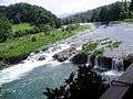 River Una in Bosanska Krupa
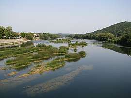 River Una in Hrvatska Kostajnica
 Una River in Kozarska Dubica
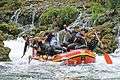 Rafting on River Una
References
- Library, Civil Society. "Akcijski plan zaštite gornjeg toka rijeke Une". CSL (Civil Society Library). Retrieved 2020-07-24.
- http://www.voda.ba/udoc/planupravljanjavodama/PD%207%20-%20BiH%20-%20Hidroloske%20analize.pdf
- http://nationalpark-una.ba/bs/podkategorija.php?id=14
- Bonacci, Ognjen (2018-06-29). "Prilog hidrologiji krškog izvora Vrelo Une". Hrvatske vode (in Croatian). 26 (104): 119–128. ISSN 1330-1144.
- Biondić, Ranko; Biondić, Božidar; Rubinić, Josip; Meaški, Hrvoje (2011). "Ocjena stanja i rizika cjelina podzemnih voda na krškom području Republike Hrvatske". Hrvatske vode pred izazovom klimatskih promjena (in Croatian): 479.
- https://www.geoubih.ba/Izdanja/acta2/Clanak-%20A.Korjenic%20Osnovne%20karakteristike%20re%C5%BEima%20voda%20i%20vodnog%20bilansa%20Une.pdf
- http://www.voda.ba/agencija
- https://predstavnickidom-pfbih.gov.ba/upload/file/sjednice/28_redovna_bs/16.pdf
- http://nationalpark-una.ba/en/kategorija.php?id=6
- http://www.ferk.ba/download_zaj/prilozi_dozvola_2008/prilozi_epbih/prilog_podaci_male_he_jpepbih.pdf
- http://old.kons.gov.ba/main.php?id_struct=6&lang=1&action=view&id=3332
- https://inis.iaea.org/collection/NCLCollectionStore/_Public/30/017/30017702.pdf
- https://www.agroklub.ba/seoski-turizam/turisti-ce-se-ipak-uskoro-vratiti-u-np-unu/59542/
- https://radiosarajevo.ba/metromahala/teme/rekordan-broj-posjetilaca-nacionalnog-parka-smaragdne-une/285735
- https://www.researchgate.net/publication/333943721_National_park_Una
- http://www.centarzakrs.ba/bh/images/stories/nas_krs/nk_33-34_2000-01%20(4).pdf
- https://www.energypress.net/nvo-protiv-hidroelektrana-na-uni/
- http://balkans.aljazeera.net/vijesti/hidroelektrane-na-uni-nece-se-graditi
- "Peace Park Plitvice-Una: New Bridge between Bosnia-Herzegovina and Croatia". newsvine.com. 2011. Retrieved 2012-04-04.
External links
| Wikimedia Commons has media related to Una River (Sava). |
Hydrography of Croatia | ||
|---|---|---|
| Rivers | 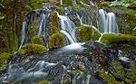 | |
| Lakes | ||
| Valleys, estuaries, canyons, wetlands | ||
| Waterfalls | ||
| Canals |
| |
| Authority control |
|
|---|