Twin Lakes, Lake County, Colorado
Twin Lakes is a census-designated place (CDP) in Lake County, Colorado, United States, near the base of Mount Elbert. The population as of the 2010 census was 171.[3] Twin Lakes has the ZIP Code 81251.[2] The name "Twin Lakes" also refers to a small unincorporated community west of the CDP along Colorado State Highway 82.
Twin Lakes, Lake County, Colorado | |
|---|---|
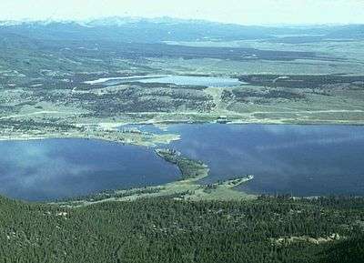
 Mount Hope from Twin Lakes | |
 Twin Lakes Location in Colorado  Twin Lakes Location in the United States | |
| Coordinates: 39°06′11″N 106°19′21″W | |
| Country | |
| State | |
| County | Lake County[1] |
| Elevation | 3,000 m (9,700 ft) |
| Population | |
| • Total | 171 |
| • Density | 3.8/km2 (9.8/sq mi) |
| Time zone | UTC-7 (MST) |
| • Summer (DST) | UTC-6 (MDT) |
| ZIP code[2] | 81251 |
| FIPS Code | 08-79105 |
| GNIS feature ID | 0180384 |
Lake County, one of the original 17 counties created by the Colorado legislature in 1861, was named for Twin Lakes. As originally defined, Lake County included a large portion of western Colorado to the south and west of its present boundaries.
The Twin Lakes District has been listed on the National Register of Historic Places since 1974.
Geography
The Twin Lakes CDP is located in southern Lake County at 39°06′11″N 106°19′21″W, about 15 miles (24 km) south of Leadville, the county seat. The CDP is bounded on the east by U.S. Route 24, on the south by State Highway 82, and on the north and west by County Highway 24. About 4 miles (6 km) west of the CDP is the original community of Twin Lakes, near the west end of the Twin Lakes Reservoir for which the communities are named. The reservoir lies south of Highway 82, outside the CDP. Highway 82 leads west across Independence Pass 40 miles (64 km) to Aspen, while US 24 leads north to Leadville and south 20 miles (32 km) to Buena Vista.
The altitude of the Twin Lakes area ranges from 9,200 feet (2,800 m) to over 9,800 feet (3,000 m), all of it somewhat lower than Leadville. Mount Elbert, the highest peak in Colorado, rises directly west of the CDP to its 14,433-foot (4,399 m) summit, just 6 miles (10 km) west of the center of the CDP.
Demographics
| Historical population | |||
|---|---|---|---|
| Census | Pop. | %± | |
| U.S. Decennial Census[4] | |||
As estimated in 2006, the following demographic data applied to ZIP code 81251, the best available approximation to the village of Twin Lakes (in Lake County):[5]
There were 216 people and 98 households residing in ZIP code 81251. The racial makeup of the village was 73.6% White, 0.5% African American, 2.3% Native American, 21.3% from other races, and 2.3% from two or more races. Hispanic or Latino of any race were 35.6% of the population.
Males were 56.9% of the population, females 43.1%. The median annual income for a household in the village was $49,322.
.jpg)
See also
- Outline of Colorado
- State of Colorado
- Colorado cities and towns
- Colorado census designated places
- Colorado counties
- Colorado metropolitan areas
- Colorado cities and towns
- Colorado Texas Tomato War
References
- "US Board on Geographic Names". United States Geological Survey. 2007-10-25. Retrieved 2008-01-31.
- "ZIP Code Lookup" (JavaScript/HTML). United States Postal Service. January 3, 2007. Retrieved January 3, 2007.
- "Geographic Identifiers: 2010 Census Summary File 1 (G001), Twin Lakes CDP, Colorado". American FactFinder. U.S. Census Bureau. Archived from the original on February 13, 2020. Retrieved September 11, 2019.
- "Census of Population and Housing". Census.gov. Retrieved June 4, 2016.
- ESRI - Products: Reports - ZIP Code Lookup: Results
External links
- Photos of Twin Lakes
- (http://www.friendsoftwinlakes.com/ Friends of Twin Lakes)
Municipalities and communities of Lake County, Colorado, United States | ||
|---|---|---|
| City |  Map of Colorado highlighting Lake County | |
| CDPs | ||
| Ghost towns | ||