Tuan Forest, Queensland
Tuan Forest is a coastal locality split between the Gympie Region and the Fraser Coast Region, both in Queensland, Australia.[2][3] In the 2016 census, Tuan Forest had a population of 0 people.[1]
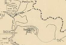
Map of Town of Tawan, 1922
| Tuan Forest Queensland | |||||||||||||||
|---|---|---|---|---|---|---|---|---|---|---|---|---|---|---|---|
 Tuan Forest | |||||||||||||||
| Coordinates | 25.7152°S 152.8069°E | ||||||||||||||
| Population | 0 (2016 census)[1] | ||||||||||||||
| • Density | 0.0000/km2 (0.0000/sq mi) | ||||||||||||||
| Postcode(s) | 4650 | ||||||||||||||
| Area | 509.3 km2 (196.6 sq mi) | ||||||||||||||
| Time zone | AEST (UTC+10:00) | ||||||||||||||
| LGA(s) | Fraser Coast Region | ||||||||||||||
| State electorate(s) | |||||||||||||||
| Federal Division(s) | Wide Bay | ||||||||||||||
| |||||||||||||||
The undeveloped town of Tawan is within the locality (25.7444°S 152.9322°E) within the Fraser Coast Region.[4]
References
- Australian Bureau of Statistics (27 June 2017). "Tuan Forest (SSC)". 2016 Census QuickStats. Retrieved 20 October 2018.

- "Tuan Forest - locality in the Gympie Region (entry 46389)". Queensland Place Names. Queensland Government. Retrieved 30 May 2019.
- "Tuan Forest - locality in the Fraser Coast Region (entry 46746)". Queensland Place Names. Queensland Government. Retrieved 30 May 2019.
- "Tawan - population centre in the Fraser Coast Region (entry 33445)". Queensland Place Names. Queensland Government. Retrieved 21 October 2019.
This article is issued from Wikipedia. The text is licensed under Creative Commons - Attribution - Sharealike. Additional terms may apply for the media files.