Transport in the Faroe Islands
The Faroe Islands is served by an internal transport system based on roads, ferries, and helicopters. As of the 1970s, the majority of the population centres of the Faroe Islands have been joined to a single road network, connected by bridges and tunnels.
International transport, both for passengers and freight, remains difficult due to high costs, long distances, and bad weather, especially during the winter. Exporting domestically produced goods is thus expensive; this limits the development of a commodity-based economy.
History
The general history of the Faroese transportation system can be divided into four periods:
Before 1900
During this first period, transportation was rather primitive; it consisted of row boats, walking, and, in certain places, horse transport (for the upper class). Boats were used for transport between villages, even on the same island, as land transport was difficult due to the steep mountains.[1]
1900 to the end of World War II
The second period commenced in the late-19th century, when ferry connections began to emerge. The ferries were largely private initiatives, but they increasingly came to be operated by the public sector. This was supplemented by an emerging culture of automobiles. After World War II, a large part of the Faroe Islands was accessible via ferries and automobiles; private buses and taxis operated as well.[2]
The end of World War II to the 1970s
The third period was characterized by modernization. The introduction of the car ferry made it possible to drive between the various city centres of the country. It became possible to drive from the capital Tórshavn to Vágur and Tvøroyri in the south, to Fuglafjørður and Klaksvík in the north, and to the airport at Sørvágur in the west. Vágar Airport was built by the British during World War II; it was reopened as a civilian international airport in 1963. Additionally, the road network was further developed. Tunnels to distant valleys and firths such as Hvalba, Sandvík, and Norðdepil were constructed in the 1960s.[3]
1970s onwards
The fourth period saw the emergence of a "mainland" thanks to tunnels and bridges. In 1973 the Streymin Bridge, the first bridge between two Faroese islands, was established between Norðskáli on Eysturoy and Nesvík on Streymoy; in 1976 the new tunnel between Norðskáli and Eysturoy was completed. The Faroes' two largest islands were connected into what is now referred to as "Meginlandið", the Mainland. In 1975 the causeway between Viðoy and Borðoy was constructed, in 1986 a similar one between Borðoy and Kunoy was established, and in 1992 the capital Tórshavn was granted a first-class connection to the northern parts of the islands, creating the infrastructural prerequisites for a mobile society on the mainland.
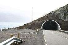
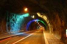
The newest developments of the Faroese transportation network are the sub-sea tunnels. In 2002 the tunnel between Streymoy and Vágar—the latter is the airport island—was finished, and in 2006 the Norðoyatunnilin between Eysturoy and Borðoy was finished.[4] A toll, payable at petrol stations, of 170 DKK (130 DKK in June 2013) is charged to drive through these two tunnels; the others are free. Now more than 85% of the Faroese population is accessible by automobile.[5]
Future
In early 2014 all political parties of the Løgting agreed to the construction of two tunnels: "Eysturoyartunnilin" a tunnel connecting Eysturoy and Streymoy will be completed by 2019 and "Sandoyartunnilin", a tunnel connecting Streymoy and Sandoy, will be completed by 2021. The combined cost of the project is estimated at almost 2 billion DKK, and will be the most expensive construction project in Faroese history. Eysturoyartunnilin is intended to have a roundabout under the sea, and possibly an airport made from tunnel excavation.[6] The three tubes will be 7,1 km, 2,1 km and 1,8 km long joined together by the roundabout. Sandoyartunnilin will be 10,6 km long.[7]
There have been talks about a possible tunnel between Sandoy and Suðuroy. The tunnel would be around 20–25 km long. If completed this would mean that 99% of the Faroes would be connected by road.
Railways
There are no passenger railways on the Faroe Islands due to the difficult landscape, small population, and relatively short distances.
Two railways have operated on the islands. A tunnel and rail system supplied a NATO radar installation, now decommissioned, which previously existed on a mountaintop in the southern part of Streymoy Island. The Gjógv incline railway operates a freight service between the harbour and the village of Gjógv on Eysturoy island.
Roads
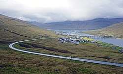
Roads have become the main method of transportation on the islands. Google Street View became available for some roads in November 2017, supplied by residents and sheep rather than Google cars.[8]
Highways
total: 960 km (600 mi)[9]
Bus services
The national bus network (Bygdaleiðir, Village routes) is operated by Strandfaraskip Landsins operating the characteristic blue buses. Most buses are modern and were built by the Volvo company. The principal route is Tórshavn-Klaksvík (via the Norðoyatunnilin tunnel and Streymin Bridge). Although individual buses are generally owned by individuals or small companies, the timetables, fares, and levels of service are set by Strandfaraskip Landsins and the government.
The municipalities of Tórshavn, Klaksvík, Eysturkommuna and Sunda operate their own free-of-charge local services, usually referred to as Bussleiðin. Tórshavn's Bussleiðin has five routes and is operated by the Tórshavn municipality. Like Bygdaleiðir, the actual buses are privately owned, but contracted to Bussleiðin. Klaksvík's service commenced in 2014.[10]
Sea
Ports and harbours
Merchant marine
total: 6 ships (1,000 gross tonnage (GT) or over) totaling 22,853 GT/13,481 tonnes deadweight (DWT) (1999 est.)
- ships by type:
- cargo ship 2,
- petroleum tanker 1,
- refrigerated cargo ship 1,
- roll-on/roll-off 1,
- short-sea passenger 1.
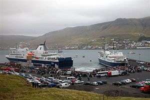
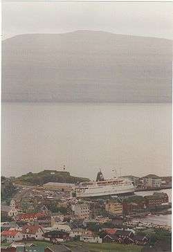
Ferries
The Faroese ferry company Strandfaraskip Landsins operates a network of ferries, in addition to the rural blue buses, called Bygdaleiðir (Villagelines). Their largest vessel is the Smyril, a roll-on/roll-off ferry which maintains the link between Tórshavn and the southern island, Suðuroy. This vessel entered service in 2005. Another ferry, Teistin, a roll-on-off ferry maintains the link between the island Sandoy and the main area, the ferry port on Streymoy is near Kirkjubøur and Velbastaður on the South-West coast of Streymoy. A sub-sea tunnel is planned between Sandoy and Streymoy, it will open in 2021 according to the plan. After that there will not be need of a ferry between the two islands. The proposed Suðuroyartunnilin would also remove the ferry services to Skúvoy and Suðuroy.
Since the early 1980s, Smyril Line has operated a regular international passenger, car and freight service using a large, modern, multipurpose ferry, the Norröna. The weekly service links the Faroe Islands with Seyðisfjörður, Iceland, and Hirtshals, Denmark.[11]
Air
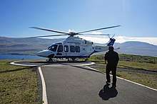
Scandinavian Airlines and Atlantic Airways both provide regular scheduled flights to Vágar Airport. Atlantic Airways being the national airline of the Faroe Islands, operating airplanes, helicopters as well as performing search and rescue responsibilities from its base at Vágar Airport. Helicopters provide domestic scheduled transportation and search and rescue activities.[12] Atlantic Airways' airplanes have regular flights to Iceland, Denmark, Norway and Scotland while there are also seasonal flights connecting the Faroe Islands with destinations such as Barcelona, Mallorca and Lisbon.[13]
Airports
One: Vágar Airport. It has a paved 1,799 m / 5,902 ft runway. It was originally built by British Royal Engineers during the Second World War.
See also
- Transport in Denmark
- Tunnels of the Faroes
- Smyril Line
- Strandfaraskip Landsins
References
- Jagd, N (27 September 1913). "Havne paa Færøerne". www.e-pages.dk. Ingeniøren. p. 505—513.
- "A note on some Faroese transport history old and new". www.countrybus.co.uk. Retrieved 8 February 2019.
- Br̆enholdt, Jryyen Ole (2007). Coping with distances : producing Nordic Atlantic societies. Berghahn Books. p. 113. ISBN 1306545838. OCLC 875641038.
- "Underwater Tunnels Revolutionize the Faroes". The Maritime Executive. Retrieved 5 June 2018.
- "Connectivity and 'Green' Craft: Exploring the Infrastructure and Architecture of the Faroe Islands". www.sah.org. Retrieved 8 February 2019.
- Airport 19
- Aktuelt.fo, Tunnilin skal upp bæði á Strondum og í Runavík
- Brulliard, Karin (7 November 2017). "How sheep with cameras got some tiny islands onto Google Street View". Washington Post / Denver Post. Retrieved 7 November 2017.
- "Vegir" (in Faroese). Tórshavn: Landsverk. Retrieved 12 April 2011.
- Bussleiðin in Klaksvík
- "Sailing Schedule". Smyril Line. Retrieved 6 September 2016.
- Parkin, Jeremy (7 April 2016). "Atlantic Airways takes delivery second new AW139". HellicopterInvestor.com.
- "Getting here by air". VisitFaroeIslands.com.
External links
- Smyril Line
- Strandfaraskip Landsins – the website of the public transport service, including schedules for busses and ferries

- Getting around Faroe Islands from Vagar Airport
Faroe Islands articles | |||||||
|---|---|---|---|---|---|---|---|
| |||||||
| History |  | ||||||
| Geography |
| ||||||
| Politics |
| ||||||
| Economy |
| ||||||
| Society |
| ||||||
| |||||||