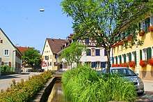
Teningen
Teningen is a municipality in the district of Emmendingen, in the state Baden-Württemberg in Germany. It is situated on the river Elz, 15 km north of Freiburg.
Teningen | |
|---|---|
 Coat of arms | |
Location of Teningen within Emmendingen district   | |
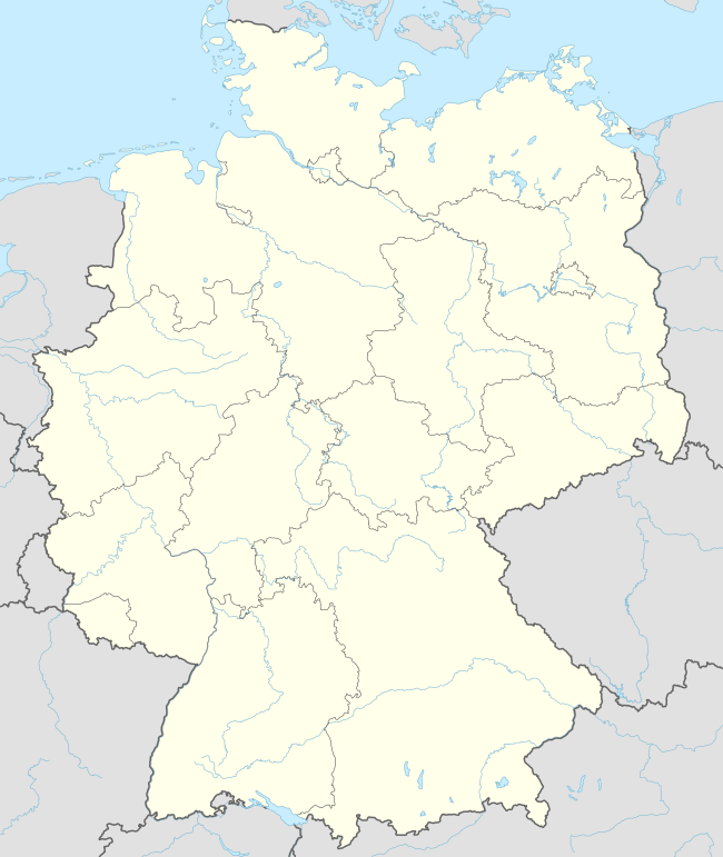 Teningen 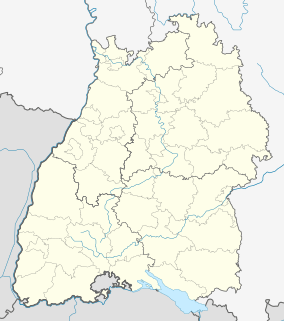 Teningen | |
| Coordinates: 48°7′37″N 7°48′37″E | |
| Country | Germany |
| State | Baden-Württemberg |
| Admin. region | Freiburg |
| District | Emmendingen |
| Subdivisions | 4 |
| Government | |
| • Mayor | Heinz-Rudolf Hagenacker (CDU) |
| Area | |
| • Total | 40.27 km2 (15.55 sq mi) |
| Elevation | 188 m (617 ft) |
| Population (2018-12-31)[1] | |
| • Total | 12,063 |
| • Density | 300/km2 (780/sq mi) |
| Time zone | CET/CEST (UTC+1/+2) |
| Postal codes | 79331 |
| Dialling codes | 07641 und 07663 |
| Vehicle registration | EM |
| Website | www.teningen.de |
Geography
Location
Teningen is set on the edge of the Black Forest mountain range.
Geology
The geological subsoil consists of sandstone and limestone and is covered by loess layers of different thickness. The Elz river created alluvial gravel and sand sediments that had been used as pastures but were adapted for agriculture in many cases.
Municipal subdivisions
The municipality Teningen comprises four districts: The main town Teningen and the formerly independent towns Heimbach, Köndringen and Nimburg.
Climate
The climate in this area is close to a mediterrean microclimate, and there is adequate rainfall year-round. However, more year-round rain occurs than in the Rhine plateau because of the closeness to the Black Forest. The Köppen Climate Classification subtype for this climate is "Cfb" (Marine West Coast Climate/Oceanic climate). However, it is close to being humid subtropical (Cfa) due to the mean temperatures in July and August just under 22 °C. The city is close to the Kaiserstuhl, a range of hills of volcanic origin located a few miles away which is considered to be one of the warmest places of Germany and therefore considered as a viticultural area. </ref: https://www.blackforest-tourism.com/Media/Villages-and-cities-from-A-Z/Ihringen-at-the-Kaiserstuhl>
| Climate data for Teningen - Emmendingen (Mundingen) 2015-2020 | |||||||||||||
|---|---|---|---|---|---|---|---|---|---|---|---|---|---|
| Month | Jan | Feb | Mar | Apr | May | Jun | Jul | Aug | Sep | Oct | Nov | Dec | Year |
| Record high °C (°F) | 15.9 (60.6) |
20.3 (68.5) |
24.0 (75.2) |
29.5 (85.1) |
33.3 (91.9) |
37.1 (98.8) |
37.7 (99.9) |
38.5 (101.3) |
32.3 (90.1) |
28.1 (82.6) |
23.8 (74.8) |
18.0 (64.4) |
38.5 (101.3) |
| Average high °C (°F) | 6.2 (43.2) |
8.1 (46.6) |
12.8 (55.0) |
17.0 (62.6) |
20.7 (69.3) |
25.4 (77.7) |
27.5 (81.5) |
26.4 (79.5) |
22.6 (72.7) |
16.3 (61.3) |
10.7 (51.3) |
7.9 (46.2) |
16.8 (62.2) |
| Daily mean °C (°F) | 2.7 (36.9) |
3.5 (38.3) |
6.9 (44.4) |
10.5 (50.9) |
14.7 (58.5) |
19.2 (66.6) |
21.1 (70.0) |
20.0 (68.0) |
15.5 (59.9) |
10.7 (51.3) |
6.4 (43.5) |
4.1 (39.4) |
11.3 (52.3) |
| Average low °C (°F) | −1.1 (30.0) |
−0.4 (31.3) |
1.3 (34.3) |
3.7 (38.7) |
8.4 (47.1) |
12.9 (55.2) |
13.8 (56.8) |
13.0 (55.4) |
9.2 (48.6) |
5.6 (42.1) |
2.1 (35.8) |
0.3 (32.5) |
5.8 (42.4) |
| Record low °C (°F) | −15.5 (4.1) |
−12.1 (10.2) |
−5.2 (22.6) |
−3.3 (26.1) |
1.7 (35.1) |
5.9 (42.6) |
5.7 (42.3) |
5.7 (42.3) |
0.6 (33.1) |
−2.5 (27.5) |
−6.9 (19.6) |
−6.7 (19.9) |
−6.8 (19.8) |
| Average precipitation mm (inches) | 63 (2.5) |
44 (1.7) |
43 (1.7) |
69 (2.7) |
119 (4.7) |
93 (3.7) |
47 (1.9) |
73 (2.9) |
52 (2.0) |
47 (1.9) |
55 (2.2) |
44 (1.7) |
749 (29.5) |
| Average precipitation days (≥ 0.2 mm) | 14.9 | 13.4 | 16.0 | 13.0 | 15.1 | 12.3 | 15.1 | 14.8 | 11.7 | 15.7 | 16.7 | 15.3 | 173.9 |
| Average rainy days (≥ 0.2 mm) | 13 | 10 | 15 | 14 | 17 | 16 | 12 | 13 | 11 | 14 | 14 | 14 | 163 |
| Average snowy days (≥ 0.2 cm) | 3.4 | 0.8 | 0.4 | 0.2 | 0 | 0 | 0 | 0 | 0 | 0 | 0.4 | 3.0 | 8.2 |
| Mean monthly sunshine hours | 71.7 | 96.3 | 136.3 | 167.5 | 199.5 | 249.6 | 238.9 | 219.9 | 165.9 | 117.3 | 70.6 | 60.3 | 1,793.8 |
| Source 1: Weather-Online[2] | |||||||||||||
| Source 2: Weather-Online[3] | |||||||||||||
Mayors
- Friedrich Engler (SPD): 1945-1946
- Wilhelm Höfflin (parteilos): 1946–1956
- Josef Schmidt (SPD): 1957–1972
- Willy Bolz (independent): 1972–1980
- Hermann Jäger (SPD): 1980–2009
- Heinz-Rudolf Hagenacker (CDU): since 2009
Twin towns


Sons and daughters of the place
- 1603: Johann Conrad Dannhauer, Protestant theologian, professor of eloquence / rhetoric, hermeneutician and poet; † 1666 in Strasbourg
- 1807: Wilhelm Theophor Dittenberger, Protestant theologian; † 1871 in Weimar
- 1899: Otto Krayer, pharmacologist, opponent against national socialist racism, since 1957 honorary citizen of Köndringen; † 1982 in Tucson / Arizona
References
- "Bevölkerung nach Nationalität und Geschlecht am 31. Dezember 2018". Statistisches Landesamt Baden-Württemberg (in German). July 2019.
- "Temperature Emmendingen - Climate Robot". Principal Station Data. Weather-Online. Retrieved 3 January 2020.
- "Klima Emmendingen - Station Emmendingen-Mundingen". Wetterdienst. Retrieved 2 February 2020.
Towns and municipalities in Emmendingen (district) | ||
|---|---|---|
Coat of arms | ||
| Authority control |
|
|---|