Tashkent Region
Tashkent Region (Uzbek: Toshkent viloyati, Тошкент вилояти) is a viloyat (region) of Uzbekistan, located in the northeastern part of the country, between the Syr Darya River and the Tien Shan Mountains. It borders with Kyrgyzstan, Tajikistan, Sirdaryo Region and Namangan Region. It covers an area of 15,300 km². The population is estimated to be around 4,450,000.
Tashkent Region Toshkent viloyati Тошкент вилояти | |
|---|---|
Region | |
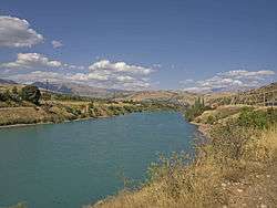 Chirchiq River in Khodzhikent | |
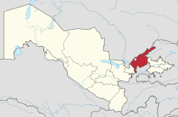 Map of Uzbekistan, location of Tashkent Region highlighted | |
| Coordinates: 41°10′N 69°45′E | |
| Country | Uzbekistan |
| administrative centre | Nurafshon |
| Government | |
| • Hokim | Rustam Kholmatov |
| Area | |
| • Total | 15,300 km2 (5,900 sq mi) |
| Population (2005) | |
| • Total | 4,450,000 |
| • Density | 290/km2 (750/sq mi) |
| Time zone | UTC+5 (East) |
| • Summer (DST) | UTC+5 (not observed) |
| ISO 3166 code | UZ-TO |
| Districts | 15 |
| Cities | 17 |
| Townships | 18 |
| Villages | 146 |
Districts
| District name | District capital | |
|---|---|---|
| 1 | Akkurgan District | Akkurgan |
| 2 | Bekabad District | Zafar |
| 3 | Bostanliq District | Gazalkent |
| 4 | Buka District | Buka |
| 5 | Chinaz District | Chinaz |
| 6 | Qibray District | Qibray |
| 7 | Parkent District | Parkent |
| 8 | Piskent District | Piskent |
| 9 | Quyi Chirchiq District | Dustobod |
| 10 | Orta Chirchiq District | Toytepa |
| 11 | Yangiyol District | Gulbakhor |
| 12 | Yukori Chirchiq District | Yangibozor |
| 13 | Zangiata District | Keles |
Overview
Tashkent Region is divided into 15 administrative districts. From 2017, the administrative centre is Nurafshon. Other cities are Angren, Olmaliq, Okhangaron, Bekabad, Chirchiq, Gazalkent, Keles, Parkent, Yangiabad, and Yangiyo‘l.
The climate is a typically continental climate with mild wet winters and hot dry summers.
Natural resources include copper, brown coal, molybdenum, zinc, gold, silver, rare earths, natural gas, petroleum, sulfur, table salt, limestone, and granite.
Toshkent Region is the most economically developed in the country. Industry includes energy production, mining, metallurgy, fertilizers, chemicals, electronics, textiles, cotton purification, food processing and footwear.
Toshkent Region also has a highly developed agricultural industry, based primarily on irrigation. The main crops are cotton and hemp, but cereals, melons and gourds, fruit and vegetables and citrus fruits are increasing. Livestock is also important.
The region has a well-developed transportation infrastructure, with over 360 km of railways and 3771 km of surfaced roads. Tashkent has a large international airport, which is the main air gateway to the country.
Chatkal National Park, with mountains and forests, is located within Tashkent Region.
References
External links
![]()
Places adjacent to Tashkent Region | ||||||||||
|---|---|---|---|---|---|---|---|---|---|---|
| ||||||||||
Capital: Tashkent | ||
| Districts and seats |
| |
| Other towns | ||
| ||