Talahi Island, Georgia
Talahi Island is a census-designated place (CDP) in Chatham County, Georgia, United States. The population was 1,248 at the 2010 census.[3] It is part of the Savannah Metropolitan Statistical Area.
Talahi Island, Georgia | |
|---|---|
 Talahi Island | |
| Coordinates: 32°1′58″N 80°58′33″W | |
| Country | United States |
| State | Georgia |
| County | Chatham |
| Area | |
| • Total | 1.5 sq mi (3.8 km2) |
| • Land | 1.3 sq mi (3.3 km2) |
| • Water | 0.2 sq mi (0.5 km2) |
| Elevation | 12 ft (4 m) |
| Population (2010) | |
| • Total | 1,248 |
| • Density | 970/sq mi (374.4/km2) |
| Time zone | UTC-5 (Eastern (EST)) |
| • Summer (DST) | UTC-4 (EDT) |
| FIPS code | 13-75239[1] |
| GNIS feature ID | 2583406[2] |
Geography
The Talahi Island CDP is located in eastern Chatham County on the island of the same name, one of several islands lying in the tidal marshes between Savannah and the Atlantic Ocean. It is bordered to the northeast by the Bull River, to the northwest by Turner Creek, and to the south by Wilmington Island. U.S. Route 80 passes through the island community, leading west 8 miles (13 km) into Savannah and east 9 miles (14 km) to the highway's end at Tybee Island on the Atlantic shore.
According to the United States Census Bureau, the Talahi Island CDP has a total area of 1.5 square miles (3.8 km2), of which 1.3 square miles (3.3 km2) is land and 0.19 square miles (0.5 km2), or 12.86%, is water.[3]
References
- "U.S. Census website". United States Census Bureau. Retrieved 2008-01-31.
- "US Board on Geographic Names". United States Geological Survey. 2007-10-25. Retrieved 2008-01-31.
- "Geographic Identifiers: 2010 Demographic Profile Data (G001): Talahi Island CDP, Georgia". U.S. Census Bureau, American Factfinder. Archived from the original on February 12, 2020. Retrieved July 24, 2014.
Municipalities and communities of Chatham County, Georgia, United States | ||
|---|---|---|
| Cities | 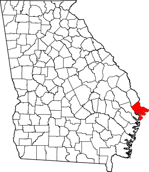 Map of Georgia highlighting Chatham County | |
| Towns | ||
| CDPs | ||
| Unincorporated communities | ||