Taihe County, Jiangxi
Taihe County (simplified Chinese: 泰和县; traditional Chinese: 泰和縣; pinyin: Tàihé Xiàn) is a county of southwest Jiangxi province, People's Republic of China, situated on the west (left) bank of the Gan River. It is under the jurisdiction of the prefecture-level city of Ji'an, 37 kilometres (23 mi) to the north-northeast.
Taihe County 泰和县 Taiho | |
|---|---|
County | |
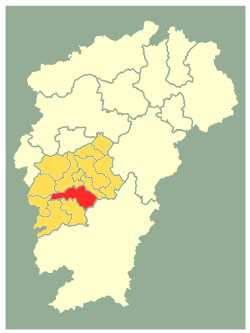 Location in Ji'an City (yellow) and Jiangxi province | |
| Coordinates: 26°47′24″N 114°54′32″E | |
| Country | People's Republic of China |
| Province | Jiangxi |
| Prefecture-level city | Ji'an |
| Area | |
| • Total | 2,666 km2 (1,029 sq mi) |
| Elevation | 57 m (188 ft) |
| Population (2010) | |
| • Total | 512,225 |
| • Density | 190/km2 (500/sq mi) |
| Time zone | UTC+8 (China Standard) |
| Area code(s) | 0796 |
| GDP (RMB) | 4.692 billion |
| Website | http://www.jxth.gov.cn/ |
Its area is almost the size of that of Rhode Island.[1]
Demographics
The population of the district was 505,795 in 1999.[2] The beautiful county consists of 16 towns, 6 villages and 2 cultivation farms. These villages and towns are called Chengjiang(Chinese: 澄江), Shuicha(水槎), Tangzhou(塘洲), Guanchao(冠朝), Shacun(沙村), Mashi(马市; 馬市), Shangmu(上模), Shangyi(上圯), Laoyingpan(老营盘; 老營盤), Zhonglong(中龙; 中龍), Xiaolong(小龙; 小龍), Heshi(禾市), Guanxi(灌溪), Bixi(碧溪), Luoxi(螺溪), Nanxi(南溪), Suxi(苏溪; 蘇溪), Qiaotou(桥头; 橋頭), Yanxi(沿溪), Shishan(石山), Yuanqian(苑前), Wanhe(万合; 萬合), Wushan Farm(武山垦殖场; 武山墾殖場) and Taihe Farm(泰和垦殖场; 泰和墾殖場) respectively.[3]
History
According to the recent archaeological discovery, the history of Taihe County can date back to the west zhou dynasty.
Education
Culture
Its famous landmark is K'uai-ko Pavilion, which Huang Tingjian wrote about.[1]
Famous Local Products
One of the most famous local products of Taihe County is Gallus domesticus, called "Taihe Wuji" in Chinese.
Climate
| Climate data for Taihe (1981−2010) | |||||||||||||
|---|---|---|---|---|---|---|---|---|---|---|---|---|---|
| Month | Jan | Feb | Mar | Apr | May | Jun | Jul | Aug | Sep | Oct | Nov | Dec | Year |
| Record high °C (°F) | 26.5 (79.7) |
31.0 (87.8) |
33.2 (91.8) |
36.2 (97.2) |
36.8 (98.2) |
38.3 (100.9) |
41.4 (106.5) |
41.5 (106.7) |
38.5 (101.3) |
36.9 (98.4) |
33.3 (91.9) |
27.4 (81.3) |
41.5 (106.7) |
| Average high °C (°F) | 10.7 (51.3) |
13.1 (55.6) |
16.9 (62.4) |
23.5 (74.3) |
28.3 (82.9) |
31.2 (88.2) |
34.8 (94.6) |
34.1 (93.4) |
30.2 (86.4) |
25.4 (77.7) |
19.5 (67.1) |
13.8 (56.8) |
23.5 (74.2) |
| Daily mean °C (°F) | 6.9 (44.4) |
9.1 (48.4) |
12.8 (55.0) |
19.0 (66.2) |
23.7 (74.7) |
26.8 (80.2) |
29.8 (85.6) |
29.0 (84.2) |
25.4 (77.7) |
20.4 (68.7) |
14.5 (58.1) |
8.9 (48.0) |
18.9 (65.9) |
| Average low °C (°F) | 4.1 (39.4) |
6.4 (43.5) |
9.8 (49.6) |
15.7 (60.3) |
20.3 (68.5) |
23.7 (74.7) |
26.0 (78.8) |
25.4 (77.7) |
22.1 (71.8) |
16.9 (62.4) |
10.9 (51.6) |
5.3 (41.5) |
15.6 (60.0) |
| Record low °C (°F) | −4.1 (24.6) |
−2.8 (27.0) |
−1.2 (29.8) |
4.0 (39.2) |
11.1 (52.0) |
14.9 (58.8) |
19.0 (66.2) |
20.2 (68.4) |
15.0 (59.0) |
4.0 (39.2) |
0.3 (32.5) |
−6.0 (21.2) |
−6.0 (21.2) |
| Average precipitation mm (inches) | 67.5 (2.66) |
99.6 (3.92) |
153.5 (6.04) |
193.3 (7.61) |
213.5 (8.41) |
223.0 (8.78) |
106.0 (4.17) |
122.4 (4.82) |
89.0 (3.50) |
66.5 (2.62) |
64.1 (2.52) |
39.3 (1.55) |
1,437.7 (56.6) |
| Average relative humidity (%) | 81 | 82 | 83 | 81 | 80 | 80 | 72 | 76 | 78 | 76 | 77 | 77 | 79 |
| Source: China Meteorological Data Service Center[4] | |||||||||||||
Scenery
Notes and references
- Chu, Hung-Lam (1998). "A Ming Society: T'ai-ho County, Kiangsi, in the Fourteenth to Seventeenth Century". 5 (2). China Review International: 401–405. Cite journal requires
|journal=(help) - Cited: p. 401: "In the minds of Chinese literati, T'ai-ho County, covering an area slightly smaller than Rhode Island, in the southwestern part of Kiangsi Province,[...]" - (in English) National Population Statistics Materials by County and City - 1999 Period, in China County & City Population 1999, Harvard China Historical GIS
- (in English) Government of Taihe County, Jiangxi Province, China - 2008 Period, in Taihe China Archived 2011-11-11 at the Wayback Machine
- 中国地面气候标准值月值(1981-2010) (in Chinese). China Meteorological Data Service Center. Retrieved 20 October 2018.
Further reading
- John W. Dardess (1996). A Ming Society: Tʻai-ho County, Kiangsi, Fourteenth to Seventeenth Centuries. University of California Press. ISBN 978-0-520-20425-6.
- Qian Hang (钱杭; Qián Háng; Ch'ien Hang), 传统与转型: 江西泰和农村宗族形态; Chuántǒng yǔ Zhuǎnxíng: Jiāngxī Tàihé Nóngcūn Zōngzú Xíngtài; Ch'uan-t'ung yu chuan-hsing: Chiang-hsi Tai-ho nung-ts'un tsung-tsu hsing-t'ai. 上海社会科学院出版社, 1995 (Shanghai). See profile at Google Books.
External links
- (in Chinese and English) Government site - Google translation
| Authority control |
|
|---|