Stockton Channel
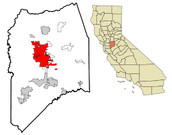
Stockton Channel is in Stockton, California. Stockton Channel runs form the San Joaquin River-Stockton Deepwater Shipping Channel at the Port of Stockton to Downtown Stockton. The Stockton Channel is often called the Stockton Waterfront, and its northeastern arm is known as McLeod Lake. The Channel is about 2.5 miles long and dates back to the 1800s. The Stockton Channel started as the Stockton Slough, a water channel made when the San Joaquin River changed course in the past. McLeod lake is named after Alexander Roderick McLeod a Hudson Bay trappers who came to Stockton to trap beavers in the area.[1][2] [3]The Stockton Marina is on the Stockton Channel. The Interstate 5 in California crosses the Channel at its midpoint. United States Army Corps of Engineers does once a year maintenance on the Stockton Channel, which requires dredging to remove silt. [4] The Mormon Slough branches off the Stockton Channel. The Stockton Channel is contained by levees. The Miners Levee is on the north side and the Tuleburg Levee on the south side. The Stockton Channel is a small part of the Sacramento–San Joaquin River Delta. The Stockton Channel over flowed its banks in the great flood of 1955. [5][6]The Smith Channel runs parallel to the north of the Stockton Channel. [7][8][9][10][11][12] There was a dam on the Mormon Slough to stop flooding and slit build up in the Stockton Channel. The Dam was removed on 24 October 2016. [13] At the downtown end of the Stockton Channel, there was in the past a creek called Miner Channel. Miner Channel ran between Miner Street and Channel Street. Miner Street sometimes flood, so it was piped and filled in. In 2000 archaeologists did an excavation of the past site of Miner Channel and uncovered artifacts from 1890s to the 1930s. The excavation was done before the new Cineplex complex was built.[14]
| Stockton Channel - McLeod lake | |
|---|---|
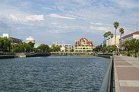 Stockton Channel at Downtown Stockton's waterfront, June 2013 | |
 | |
| Location | |
| Country | United States |
| State | California |
| Physical characteristics | |
| Source | |
| • location | San Joaquin River |
| • elevation | 13 ft (4.0 m) |
| Mouth | |
• location | |
• coordinates | 37.953°N 121.32°W |
| Length | 2.5 mi (4.0 km) |
| Width | |
| • minimum | 200 ft (61 m) |
| • maximum | 380 ft (120 m) |
| Depth | |
| • minimum | 9 ft (2.7 m) |
| • maximum | 35 ft (11 m) |
| Basin features | |
| River system | Sacramento–San Joaquin Delta |
| Bridges | Interstate 5 |
| Inland ports |
|


On the Stockton Channel
Major properties on the Stockton Channel - Stockton Waterfront are:
- San Joaquin River
- The east part of the Port of Stockton
- Penny Newman Grain Company
- Stockton Cement Terminal
- Stockton Downtown Marina
- Joan Darrah Promenade
- 5 Star Marina
- Ebony Boat Club
- I-5 Bridge
- Morelli Park and Morelli Park Boat Launch
- Children's Museum of Stockton
- Stockton Waterfront Events Center
- Banner Island Ballpark
- Weber Point at the east end of the Stockton Channel
- Weber Point Event Center [15][16]
- McLeod Park at the east end of the Stockton Channel
- McLeod Lake Plaza
- Dean DeCarli Waterfront Plaza
- Stockton Arena, home venue of the Stockton Heat
- Stockton Ports HQ
- Delta Yacht Club
- University Plaza Waterfront Hotel
- Weber Institute of Applied Sciences & Technology
- Hunter Square Plaza
- Stockton Memorial Civic Auditorium
Historical landmarks on Stockton Channel
There are a number of historical landmarks on Stockton Channel:
- Miner Levee Site (1927), north side of Stockton Channel between Harrison and Lincoln streets. The site was added to the city register by resolution number 33,837 on January 31, 1977.
- The Hotel Stockton (1910), 133 E Weber Ave, Stockton Weber and El Dorado streets. Constructed in a Mission/Spanish Revival style by local businessmen Lee A. Phillips, Frank A. West, Samuel Frankenheimer, and Edgar B. Brown (architect), the hotel was constructed on a parcel known as "Weber Hold," at the head of the Stockton Channel. As the first reinforced concrete structure in the Central Valley, the hotel was constructed at a cost of $500,000. When it opened for business on May 25, 1910, it included 252 rooms (200 with private baths) and a roof garden with a fountain and pergola. The hotel underwent an extensive renovation in 1950 at a cost of $200,000, but was the victim of poor timing. The increasing use of automobiles led to more convenient roadside motels with ample parking, and rising costs, led the hotel to close on November 26, 1960. For a number of years, the building was home to numerous county offices, including the Department of Public Assistance, due to the demolition of the old courthouse. However, the county offices vacated in 1992 when they moved into new facilities. Since then, the old hotel has been restored, and officially reopened to the public on March 17, 2005; it features exact replicas of the oak railings and wainscoting, the original fireplace, and restored leaded stained glass panels. The upper floors now contain 156 apartments for low- and fixed-income residents, as well as a 10,000-square-foot (930 m2) rooftop terrace. The building is #81000174 on the National Register of Historic Places and was added on April 1, 1981. The building was added to the city register by resolution number 29,086 on June 1, 1971.[17][18]
- Stockton Memorial Civic Auditorium (1924–25), 525 North Center Street. The city of Stockton constructed the Civic Auditorium as a venue for large community events, prompted by plans to commemorate the Stockton men who had been killed in World War I. The city wanted to create a central plaza fringed by the auditorium, the city hall, and the library, and decided on a site near McLeod Lake. A bond election was held in October 1920 to raise funds for site purchase and construction. Designed by Glenn Allen and the firm of Wright & Satterlee, construction began in 1924, was completed in 1925, and dedicated on Veteran's Day. The finished structure featured exterior brick walls with cement plaster finish (imitating Indiana limestone), interior brick walls covered with reinforced concrete or metal lath and plaster, roof and balcony of reinforced concrete, floors of white maple over a concrete sub-floor, and a roof of "Armso" iron over felt. It contains a 45' x 96' stage, twelve dressing rooms, nine committee rooms, a press room, and two dressing rooms for the lecture room stage. The building can accommodate 5,000 people, and was added to the city register by resolution number 90-0198 on March 15, 1990. Allen and Young are also known for the Henry Apartments (1913), Goold and John's Tudor Flats (1924) at 938-944 North Sutter Street, First Church of Christ Scientist (1928), and the Jewish Community Center (1928).[19][20]
Past properties on the Stockton Channel
Past major properties on the Stockton Channel:
- Stockton Ordnance Depot
- Pollock-Stockton Shipbuilding Company
- Pacific Tannery
- Jacob Wagner Tannery
- Stockton harbor
- Lindsay Point, by Thomas Lindsay
- 1850 House built by Captain Charles Maria Weber, founder and pioneer (at Weber Point)
- Old Masonic Temple on El Dorado Street
References
- biographi.ca, Alexander Roderick McLeod
- Remembering Stockton history, J. Frederick Loeber (1840-1906)
- The San Joaquin: A River Betrayed, By Gene Rose, page 22
- Feinstein, senate.gov Bugest , May 22 2009
- recordnet.com, Flooding its happened before
- recordnet.com, 1955 flood a disaster
- Engineering Record, Building Record and Sanitary Engineer, Volume 61, page 782, by Edward J. Mehren, Henry Coddington Meyer, John M. Goodell, June 1910
- Stockton Marina
- City of Stockton, History, Miner Channel Historic Block A New Site Discovered
- KCRA, Upgrades coming to I-5 bridge in Stockton, Jun 1, 2018
- City of Stockton, History
- Port of Stockton, about
- Stockton East Water District , 2016 Dam Removal Schedule
- Stockton City, Miner Channel Historic Block, A New Site Discovered
- Weber Point Event Center
- Weber Point Event Center
- City of Stockton - Hotel Stockton Archived 2007-09-30 at the Wayback Machine
- .sanjoaquinhistory.org, San Joaquin History, page 5
- City of Stockton - Stockton Memorial Civic Auditorium Archived 2007-09-30 at the Wayback Machine
- Report of the Chief of Engineers U.S. Army, Part 1, 1923, By United States. Army. Corps of Engineers, page 1669-1672
Places adjacent to Stockton Channel | ||||||||||
|---|---|---|---|---|---|---|---|---|---|---|
| ||||||||||
External links
| Panamax ports | |
|---|---|
| Non-panamax ports | |
| Canals | |
| Alternate West Coast Seaports |
|
| West Coast LNG Terminals | |