Stevns Municipality
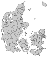
Stevns is a municipality (Danish, kommune) in Region Sjælland on the southeast coast of the island of Zealand (Sjælland) in south Denmark. The municipality covers an area of 250 square kilometres (97 sq mi), and has a population of 22,782 (1 January 2019). The municipality covers most of Stevns Peninsula.
Stevns Municipality Stevns Kommune | |
|---|---|
 Coat of arms | |
 | |
| Country | Denmark |
| Region | Region Zealand |
| Seat | Store Heddinge |
| Government | |
| • Mayor | Annette Mortensen (V) |
| Area | |
| • Total | 249.92 km2 (96.49 sq mi) |
| Population (1 January 2019) | |
| • Total | 22,782 |
| • Density | 91/km2 (240/sq mi) |
| Time zone | UTC+1 (CET) |
| • Summer (DST) | UTC+2 (CEST) |
| Municipal code | 336 |
| Website | www.stevns.dk |
.JPG)
The third largest town and the site of its municipal council is the town of Hårlev.
On 1 January 2007 Stevns municipality, as the result of Kommunalreformen ("The Municipal Reform" of 2007), merged with Vallø municipality to form an enlarged Stevns municipality.
The town of Store Heddinge
The town of Store Heddinge came into existence during the 13th century, and Saint Katharina Church (Sct. Katharina kirke) is also from that time. The town received privileged status as a merchant town in 1441. A Latin preparatory school was founded in the town in 1620, but was closed down in 1739.
Locations
The ten largest locations in the municipality are:
| Strøby Egede | 3,900 |
| Store Heddinge | 3,200 |
| Hårlev | 2,500 |
| Rødvig | 1,600 |
| Valløby | 760 |
| Strøby | 670 |
| Hellested | 610 |
| Klippinge | 520 |
| Magleby | 320 |
| Lyderslev | 320 |
Politics
Municipal council
Stevns' municipal council consists of 19 members, elected every four years.
Below are the municipal councils elected since the Municipal Reform of 2007.
| Election | Party | Total seats |
Turnout | Elected mayor | |||||||||
|---|---|---|---|---|---|---|---|---|---|---|---|---|---|
| A | B | C | F | L | N | O | V | Ø | |||||
| 2005 | 9 | 2 | 1 | 2 | 13 | 27 | 74.6% | Poul Arne Nielsen (V) | |||||
| 2009 | 6 | 1 | 2 | 2 | 1 | 7 | 19 | 71.0% | |||||
| 2013 | 5 | 1 | 1 | 1 | 2 | 8 | 1 | 75.2% | Mogens H. Nielsen (V) | ||||
| 2017 | 6 | 1 | 2 | 2 | 2 | 4 | 2 | 72.7% | Anette Mortensen (V) | ||||
| Data from Kmdvalg.dk 2005, 2009, 2013 and 2017 | |||||||||||||
Attractions
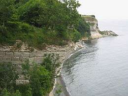
The area is known for its white chalk cliffs, which are quite rare in Denmark. Stevns Klint (Stevns' Cliffs), a popular tourist attraction, is one of these. The old town church by the small village of Højerup collapsed partially over the cliffs in 1928 due to erosion.
The cliffs at Højerup are also the place where the father-and-son team of scientists Luis and Walter Alvarez measured[1] the highest level of iridium in the Cretaceous–Paleogene boundary layer, which led them to propose their hypothesis that the Cretaceous–Paleogene extinction event was caused by an impact of a large asteroid 66 million years ago.
By 2014 Stevns Klint was listed on UNESCO List of World Heritage Sites in Northern Europe.
In 2008 the Cold War Museum Stevns Fortress opened to the public. It features a large exhibition of military equipment and a 1.5-hour guided tour in the large underground system of the fortress. The underground system of the fortress features 1.6 kilometres (0.99 mi) of tunnels, living quarters, command centers, hospital and even a chapel. And in addition two ammunition depots for its two 15 centimetres (5.9 in) cannons. The tunnels are 18–20 metres (59–66 ft) below surface excavated in the chalk of Stevns. This top secret fortress was built in 1953 and remained operational until 2000.
Stevns is also home to Elverhøj (Elves' Hill), while not much of an attraction, it is famous for the fairy tale The Elf Mound by H.C. Andersen and the Danish national play Elves' Hill, both of which in Danish share the name Elverhøj.
Notable people of the wider Municipality

- Peder Syv (1631–1702) a Danish philologist, folklorist and parish priest at Hellested from 1664 until 1702
- Berte Skeel (1644 in Vallø Castle – 1720) a Danish noble, philanthropist and estate owner, she owned Selsø Manor
- Jens Juel-Vind (1694 in Huellinge - 1726), baron of Juellinge, a Danish chamberlain and landowner.
- Christen Lindencrone (1703-1772) a Danish landowner and supercargo, owned Gjorslev Manor 1743-1772
- Severine Casse (1805 in Lyderslev – 1898) a Danish women's rights activist and an influential member of the Danish Women's Society
- Hans Peter Johan Lyngbye (1834 in Vallø Castle - 1920) a Danish businessman, dealing with timber and salvage
- Gunnar Asgeir Sadolin (1874 in Valløby - 1955) a Danish businessman and manufacturer of dry pigments and Aniline dyes
- Gitte Karlshøj (born 1959 in Lyderslev) a Danish long-distance runner, ran the 3000 metres at the 1992 Summer Olympics
Image gallery
 St. Catherine's Church, Store Heddinge
 Gjorslev Castle
 Boesdal Kalkbrud
References
- Alvarez, Luis W.; Alvarez, Walter; Asaro, Frank; Michel, Helen V. (June 6, 1980). "Extraterrestrial cause for the Cretaceous–Tertiary extinction". Science. 208 (4448): 1095–1108. CiteSeerX 10.1.1.126.8496. doi:10.1126/science.208.4448.1095. PMID 17783054.
- Municipal statistics: NetBorger Kommunefakta, delivered from KMD aka Kommunedata (Municipal Data)
- Municipal mergers and neighbors: Eniro new municipalities map
External links
| Wikimedia Commons has media related to Stevns Kommune. |