Stannington (ward)
Stannington ward is one of the 28 electoral wards in the City of Sheffield, England. It is located in the western part of the borough, including some westernmost suburbs of the city; most of the land is rural. The population of the ward at the 2011 Census was 18,222.[1]
| Stannington | |
|---|---|
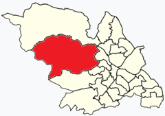 Shown within Sheffield | |
| Population | 18,222 (2011) |
| Metropolitan borough |
|
| Metropolitan county | |
| Region | |
| Country | England |
| Sovereign state | United Kingdom |
| UK Parliament | |
| Councillors | David Baker (Liberal Democrats) Vickie Priestley (Liberal Democrats) Penny Baker (Liberal Democrats) |
It is one of the wards that make up the Sheffield Hallam parliamentary constituency.
Description
The population of this ward in 2011 was 18,222 in 8,030 Households[1] in a land area of 102 km2 (39 sq mi), of which over 90% is greenspace.[2]
Most of the area of the ward is covered by the civil parish of Bradfield.[3]
The ward includes parts of the western fringes of the greater connurbation of Sheffield, including: the Stannington and Middlewood suburbs of Sheffield, and the village suburbs of Loxley and Worrall, all located on the eastern fringes of the ward. The remainder of the eastern half of the ward is mostly agricultural land, including some industry, and several reservoirs (Damflask Reservoir, Dale Dike Reservoir, Strines Reservoir, and Agden Reservoir) and includes the villages of Low Bradfield, High Bradfield, and Dungworth.[3][4]
The western part of the ward is moorland, including Howden and Bradfield moors, and contains no significant settlements.[3][4]
See also
- Moscar Cross, boundary marker and guide stone, and area on the Derbyshire border.
Locations
- Stannington (suburb)53.396479°N 1.536021°W, (grid reference SK309889)
- Loxley 53.4049°N 1.5378°W, (grid reference SK310900)
- Worral 53.424354°N 1.538728°W, (grid reference SK307920)
- Low Bradfield 53.422900°N 1.605400°W,
- High Bradfield 53.428800°N 1.598100°W, (grid reference SK267923)
- Dungworth 53.406522°N 1.578030°W, (grid reference SK281900)
- Middlewood 53.420000°N 1.520000°W
References
- "Key Figures for 2011 Census: Key Statistics – Area: Stannington (Ward)". Neighbourhood Statistics. Office for National Statistics. Retrieved 9 August 2016.
- Area: Stannington (Ward) - Key Figures for Physical Environment, Office for National Statistics
- "Area: Bradfield CP (Parish)", 2001 Census: Key Statistics, Office for National Statistics
- Ordnance Survey, 1:25000. c.2012
External links
- Area: Stannington (Ward), Office for National Statistics
| About Sheffield | |||||
|---|---|---|---|---|---|
| Electoral wards |
| ||||
| Suburbs and estates |
| ||||
| Towns and villages |
| ||||
| Other areas | |||||
| |||||