St. Malo, Manitoba
St. Malo is an unincorporated community recognized as a local urban district[3] located in the Rural Municipality of De Salaberry, approximately 70 km south of The Forks, Winnipeg, Manitoba. Most of the community's residents are bilingual francophone of Métis or Québécois heritage.
St. Malo | |
|---|---|
| Country | Canada |
| Province | Manitoba |
| RM | De Salaberry |
| Established | 1877 |
| Government | |
| • Type | Local urban district (L.U.D.) |
| • RM Reeve | M. Marion |
| • St. Malo Ward Council Members | D. Curé & G. Gosselin |
| • L.U.D. Chair | J. Gosselin |
| • L.U.D. Members | M. Comeault & F. Lambert |
| Area | |
| • Total | 7.34 km2 (2.83 sq mi) |
| Elevation .(St Malo & Bourgeois)[1] | 252 m (827 ft) |
| Population (2016[2]) | |
| • Total | 1,227 |
| • Density | 167/km2 (430/sq mi) |
| Time zone | UTC-6 (CST) |
| • Summer (DST) | UTC-5 (CDT) |
| Area code(s) | 204 |
Early history
Chronology of the early settlement of St. Malo:
- 1877 - Born in Varennes, Quebec, Louis Malo is the first pioneer to settle in St. Malo.[4][5][6][7][8]
- 1878 - Opening of the Pembina Branch rail line from St. Boniface to Dominion City through nearby Dufrost station. The new rail route resulted in the phasing-out of the generations-old Crow Wing ox trail through St. Malo; Dufrost began part of St. Malo parish.[9]
- 1884 - Surveying of the St. Malo Settlement of lots along the Rat River (a tributary of the Red River) from the southern edge of the village of St. Malo to La Rochelle.[4][10]
- 1892 - Opening of register for the St. Malo parish of the Manitoban archdiocese of St. Boniface.[11][12] St. Malo Post Office established February 1, 1892.[13]
Geography
St. Malo lies in the eastern edge of the remarkably flat Red River flood plain, which was once the lake shore of Lake Agassiz at the transition between southeastern Manitoba's upland woodlands to the east and the flat prairie grasslands to the west.[14][15]
Description
St. Malo is a shopping and services centre for the surrounding rural area; it is also recognized for its tourist attractions and farming.
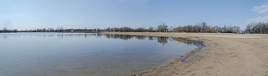
Popular activities in St. Malo during the winter months include snowmobiling, cross-country skiing, hockey, as well as ice-fishing and car racing on the lake. In February 2008, the Friends of the Park ("Les Amis du Parc") organized its first annual Festival of Friends ("Festival des Amis").
École Saint-Malo School is the community's elementary and middle school and is part of the Red River Valley School Division. The school offers both French Immersion and English programs.
Notable people
- Travis Hamonic, professional hockey player
See also
Friendship communities
.svg.png)

Bibliography
- Census Profile, 2016 Census (online). "St. Malo, Local urban district".CS1 maint: ref=harv (link)
- Canada. Dept. of the Interior (1890). "Annual Report of the Department of the Interior for the Fiscal Year 1890".CS1 maint: ref=harv (link)
- L&A Canada (online). "Library and Archives Canada, Post Offices and Postmasters".CS1 maint: ref=harv (link)
- Parks Canada (2008). "Manitoba History: Commemorating the First Railway in Western Canada". Manitoba Historical Society.CS1 maint: ref=harv (link)
- The De Salaberry-St Pierre Heritage Advisory Committee (online). "Landmarks: Significant Heritage Buildings of De Salaberry and St. Pierre" (PDF).CS1 maint: ref=harv (link)
- Ledohowski (pdf 1), E.M. (2003). "The Heritage Landscape of the Crow Wing Study Region of Southeastern Manitoba - Introduction" (PDF).CS1 maint: ref=harv (link)
- Ledohowski (pdf 3), E.M. (2003). "The Heritage Landscape of the Crow Wing Study Region of Southeastern Manitoba - Settlement Groups" (PDF).CS1 maint: ref=harv (link)
- Malo, Jean-Pierre; edited by Olivier, Réjean (2015). Les Hayet (Ayet) dit Malo de la rive-nord: forts et fertiles!. Collection Oeuvres bibliophiliques de Lanaudière (in French) (Private ed.). ISBN 978-2-924448-52-6.CS1 maint: extra text: authors list (link) CS1 maint: ref=harv (link) 68 pages, L&A Canada link
- Manitoba LUDR (online). "Local Urban Districts Regulation". Government of Manitoba.CS1 maint: ref=harv (link)
- PRDH (online). "List of the pioneers, Jean-Baptiste Ayet-Malo". Programme de recherche en démographie historique (Research Program in Historical Demography), Montreal University.CS1 maint: ref=harv (link)
- Manitoba Historical Society (online). "Historic Sites of Manitoba: St. Malo Grotto (RM of DeSalaberry)".CS1 maint: ref=harv (link)
- Rivers West (online). "Routes of the Red, Shores of Lake Agassiz" (PDF). Red River Corridor Inc.CS1 maint: ref=harv (link)
- SHSB (1940). Saint-Malo: paroisse manitobaine. Saint-Boniface, Man.: Société historique de Saint-Boniface / Peel Library, University of Alberta.CS1 maint: ref=harv (link)
- Livre du centenaire de la paroisse Saint-Malo (1994). Saint-Malo, Dufrost, La Rochelle: À l'ombre de nos clochers.CS1 maint: ref=harv (link)
- Therrien, Joanne (2007). Saint-Malo : la beauté de la nature / St. Malo : nature's beauty. Winnipeg: Vidacom. ISBN 978-2-923653-03-7.
- Worldwide Elevation Map Finder (online). "Saint Malo, MB R0A 1T0, Canada".CS1 maint: ref=harv (link)
Endnotes
- Worldwide Elevation Map Finder (online), accessed April 7, 2017
- Census Profile, 2016 Census (online), accessed April 7, 2017
- Manitoba LUDR (online), accessed April 24, 2016
- Ledohowski (pdf 3) 2003, §5.3.15, p. 46
- Louis Malo is a descendant of Jean Hayet dit Saint-Malo (~1639 Saint-Malo, Brittany - 1721 Varennes, New France). We can thus suppose that the place-name St. Malo in Manitoba derives from the patronymic evolution which ensues from, on one hand, the surname 'Hayet dit Saint-Malo', whose 1st ancestor to settle in ancient Quebec was a native of Saint-Malo, the port city in Brittany, became the 6th generation descendant Louis Malo, and, on the other hand, the place where this pioneer Louis Malo settled in Manitoba to re-surface, so to speak, by multiple association, as the place-name St. Malo. Brittany's Saint-Malo originally derives for the Welsh medieval monk Malo (or Maclou), who was bishop of Saint-Malo and one of Brittany's seven founding saints.
- PRDH (online), accessed April 28, 2017
- Malo & edited by Olivier 2015, pp. 11,13,15
- See Manitoba Land Titles Office abstract for lot 90.
- Parks Canada 2008, This first railway line built in Canadian West, officially opened on December 3, 1878, brought prosperity to the region.
- Canada. Dept. of the Interior 1890, p. 91
- Livre du centenaire de la paroisse Saint-Malo 1994, p. 15
- SHSB 1940, p. 29
- L&A Canada (online), accessed April 7, 2017
- Rivers West (online), Some of the flattest land in the world is located in the Red River Valley.
- Ledohowski (pdf 1) 2003, §1.4, p. 4
External links
Adjacent communities
Places adjacent to St. Malo, Manitoba | |
|---|---|
| Cities |  | ||
|---|---|---|---|
| Towns | |||
| Villages | |||
| Rural municipalities |
| ||
| First Nations | |||
| Indian reserves | |||
| Unincorporated communities | |||