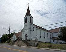
St. Bonifacius, Minnesota
St. Bonifacius is a city in Hennepin County, Minnesota. It is centered on Minnesota State Highway 7 and County Road 92, and located 25 miles west of Minneapolis. It is part of the Waconia School District. The population was 2,283 at the 2010 census.[5] It is one square mile and completely surrounded by the city of Minnetrista.
Saint Bonifacius | |
|---|---|
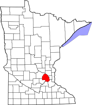
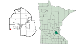 Location of Saint Bonifacius within Hennepin County, Minnesota | |
| Country | United States |
| State | Minnesota |
| County | Hennepin |
| Government | |
| • Mayor | Shawn Routsinoja [1] |
| Area | |
| • Total | 1.04 sq mi (2.70 km2) |
| • Land | 1.04 sq mi (2.69 km2) |
| • Water | 0.00 sq mi (0.00 km2) |
| Population | |
| • Total | 2,283 |
| • Estimate (2019)[4] | 2,374 |
| • Density | 2,282.69/sq mi (881.58/km2) |
| Time zone | UTC-6 (Central (CST)) |
| • Summer (DST) | UTC-5 (CDT) |
| FIPS code | 27-56770 |
| Website | www |
St. Bonifacius is home to Crown College, a college of the Christian and Missionary Alliance.
Geography
According to the United States Census Bureau, the city has a total area of 1.07 square miles (2.77 km2), of which 1.06 square miles (2.75 km2) is land and 0.01 square miles (0.03 km2) is water.[6] It is completely surrounded by the city of Minnetrista.
Demographics
| Historical population | |||
|---|---|---|---|
| Census | Pop. | %± | |
| 1910 | 275 | — | |
| 1920 | 332 | 20.7% | |
| 1930 | 336 | 1.2% | |
| 1940 | 363 | 8.0% | |
| 1950 | 438 | 20.7% | |
| 1960 | 576 | 31.5% | |
| 1970 | 685 | 18.9% | |
| 1980 | 857 | 25.1% | |
| 1990 | 1,180 | 37.7% | |
| 2000 | 1,873 | 58.7% | |
| 2010 | 2,283 | 21.9% | |
| Est. 2019 | 2,374 | [4] | 4.0% |
| U.S. Decennial Census | |||
2010 census
As of the census[3] of 2010, there were 2,283 people, 863 households, and 624 families living in the city. The population density was 2,153.8 inhabitants per square mile (831.6/km2). There were 912 housing units at an average density of 860.4 per square mile (332.2/km2). The racial makeup of the city was 94.2% White, 1.9% African American, 0.1% Native American, 1.8% Asian, 0.1% Pacific Islander, 0.5% from other races, and 1.4% from two or more races. Hispanic or Latino of any race were 3.2% of the population.
There were 863 households, of which 41.4% had children under the age of 18 living with them, 63.2% were married couples living together, 7.3% had a female householder with no husband present, 1.9% had a male householder with no wife present, and 27.7% were non-families. 20.7% of all households were made up of individuals, and 5.3% had someone living alone who was 65 years of age or older. The average household size was 2.65 and the average family size was 3.12.
The median age in the city was 36.2 years. 28.9% of residents were under the age of 18; 5.2% were between the ages of 18 and 24; 32.1% were from 25 to 44; 25.4% were from 45 to 64; and 8.5% were 65 years of age or older. The gender makeup of the city was 50.9% male and 49.1% female.
2000 census
As of the census[7] of 2000, there were 1,873 people, 681 households, and 546 families living in the city. The population density was 1,756.5 people per square mile (675.9/km2). There were 695 housing units at an average density of 651.8 per square mile (250.8/km2). The racial makeup of the city was 97.01% White, 0.16% African American, 0.11% Native American, 0.91% Asian, 0.59% from other races, and 1.23% from two or more races. Hispanic or Latino of any race were 1.76% of the population.
There were 681 households, out of which 45.1% had children under the age of 18 living with them, 69.8% were married couples living together, 7.0% had a female householder with no husband present, and 19.8% were non-families. 15.0% of all households were made up of individuals, and 3.7% had someone living alone who was 65 years of age or older. The average household size was 2.75 and the average family size was 3.07.
In the city, the population was spread out, with 29.5% under the age of 18, 6.4% from 18 to 24, 41.1% from 25 to 44, 16.7% from 45 to 64, and 6.5% who were 65 years of age or older. The median age was 32 years. For every 100 females, there were 108.1 males. For every 100 females age 18 and over, there were 107.1 males.
The median income for a household in the city was $65,446, and the median income for a family was $69,938. Males had a median income of $43,173 versus $31,354 for females. The per capita income for the city was $24,933. About 2.8% of families and 3.2% of the population were below the poverty line, including 4.8% of those under age 18 and 2.4% of those age 65 or over.
Education
Waconia Public Schools operates the area public schools,[8] including Waconia High School.
Notable people
- Milt Bruhn (1912–1991), American football player and coach
References
- http://www.ci.st-bonifacius.mn.us/
- "2019 U.S. Gazetteer Files". United States Census Bureau. Retrieved July 26, 2020.
- "U.S. Census website". United States Census Bureau. Retrieved 2012-11-13.
- "Population and Housing Unit Estimates". United States Census Bureau. May 24, 2020. Retrieved May 27, 2020.
- "2010 Census Redistricting Data (Public Law 94-171) Summary File". American FactFinder. U.S. Census Bureau, 2010 Census. Retrieved 23 April 2011.
- "US Gazetteer files 2010". United States Census Bureau. Archived from the original on 2011-02-20. Retrieved 2012-11-13.
- "U.S. Census website". United States Census Bureau. Retrieved 2008-01-31.
- "Why Waconia". Waconia Public Schools. Retrieved 2020-03-28.
External links
Municipalities and communities of Hennepin County, Minnesota, United States | ||
|---|---|---|
| Cities |
|  Map of Minnesota highlighting Hennepin County |
| Unorganized territory | ||
| Footnotes | ‡This populated place also has portions in an adjacent county or counties | |