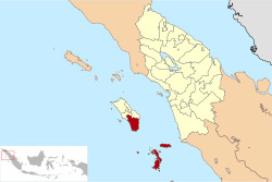
South Nias Regency
Nias Selatan (South Nias) Regency is a regency in North Sumatra province, Indonesia. In 2015, the regency covered an area of 2,487.98 square kilometres and according to the 2010 census had a population of 289,708;[2] the 2015 Census showed a population of 308,281[3] and the latest estimate (for 2019) is 360,683.[4] Its administrative centre is the port of Teluk Dalam. Apart from the southern portion of Nias Island, the regency also includes the smaller Batu Islands (Pulau Pulau Batu) to the south, lying between Nias and Siberut.
South Nias Regency (Kabupaten Nias Selatan) | |
|---|---|
Seal | |
 | |
| Country | Indonesia |
| Province | Sumatera Utara |
| Regency seat | Teluk Dalam |
| Government | |
| • Regent | Hilarius Duha |
| • Vice Regent | Sozanolo Ndruru |
| • Chairman of Council of Representatives | Elisati Halawa (PDI-P) |
| • Vice Chairmen of Council of Representatives | Fa'atulö Sarumaha (Nasdem) and Agustana Ndruru (Golkar) |
| Area | |
| • Total | 2,487.98 km2 (960.61 sq mi) |
| Population (2019)[1] | |
| • Total | 360,683 |
| • Density | 140/km2 (380/sq mi) |
| Time zone | UTC+7 (WIB) |
| Website | niasselatankab.go.id |

Administrative districts
The regency was divided into eighteen districts (kecamatan) at the time of the 2010 Census, However, since 2010 seventeen additional districts have been created from parts of existing districts, notably in the Batu Islands where there are now seven districts compared with the three in 2010, but also on Nias Island itself where there are now twenty-eight districts within the Regency compared with fifteen in 2010. These are all tabulated below with their areas (in km2) and their 2010[5] and 2015[6] Census populations:
| Name | Area in km2 | Population Census 2010[7] | Population Census 2015[8] |
|---|---|---|---|
| Hibala | 225.75 | 9,620 | 4,449 |
| Tanah Masa | 451.43 | (a) | 3,626 |
| Pulau Pulau Batu (Batu Islands) | 105.09 | 16,365 | 6,491 |
| Pulau Pulau Batu Timur (East Batu Islands) | 372.05 | 2,483 | 1,678 |
| Simuk | 20.42 | (b) | 1,217 |
| Pulau Pulau Batu Barat (West Batu Islands) | 21.06 | (b) | 1,511 |
| Pulau Pulau Batu Utara (North Batu Islands) | 6.30 | (b) | 2,447 |
| Total Kepulauan Batu | 1,201.10 | 28,468 | 21,419 |
| Teluk Dalam | 41.30 | 27,801 | 19,129 |
| Fanayama | 82.49 | 19,844 | 18,400 |
| Toma | 41.26 | 8,013 | 10,367 |
| Maniamolo | 75.32 | 13,434 | 9,802 |
| Mazino | 39.49 | 8,274 | 10,931 |
| Luahagundre Maniamolo | 50.39 | (c) | 8,452 |
| Onolalau | 25.37 | (c) | 5,278 |
| Amandraya | 76.76 | 17,099 | 10,478 |
| Aramo | 63.49 | 7,762 | 14,622 |
| Ulususua | 57.18 | (c) | 11,180 |
| Lahusa | 80.36 | 34,915 | 21,854 |
| Sidua'ori | 62.40 | (c) | 7,253 |
| Somambawa | 40.63 | (c) | 12,301 |
| Gomo | 37.56 | 25,078 | 9,626 |
| Susua | 28.23 | 14,966 | 18,457 |
| Mazo | 29.03 | 15,129 | 10,052 |
| Umbunasi | 32.81 | 7,840 | 10,186 |
| Idanotae | 28.31 | (c) | 9,837 |
| Ulu Idanotae | 14.33 | (c) | 6,460 |
| Boronadu | 29.33 | (c) | 8,339 |
| Lolomatua | 21.59 | 25,198 | 7,912 |
| Ulunoyo | 48.99 | (c) | 9,108 |
| Huruna | 49.28 | (c) | 10,330 |
| Lolowa'u | 48.03 | 30,088 | 5,816 |
| Hilimegai | 40.15 | 5,799 | 5,628 |
| O'o'u | 73.16 | (c) | 5,813 |
| Onahazumba | 28.45 | (c) | 4,940 |
| Hilisalawa | 40.19 | (c) | 4,311 |
Notes:
(a) The 2010 population of Tanah Masa District (comprising that part of Tanahmasa Island previously part of Hibala District) is included in the 2010 population of Hibala District.
(b) The 2010 populations of Simuk District (Simuk Island), Pulau Pulau Batu Barat District and Pulau Pulau Batu Utara District are included in the 2010 population of Pulau Pulau Batu District.
(c) The 2010 populations of the thirteen new districts on Nias Island are included in the 2010 populations of the districts from which they were split off.
The four new districts in the Batu Islands are Pulau Pulau Batu Barat (West Batu Islands), Pulau Pulau Batu Utara (North Batu Islands), Simuk (Simuk Island) and Tanah Masa (that part of Tanahmasa Island previously part of Hibala District). The thirteen new districts on Nias Island itself are Hilisalawa'ahe, O'o'u, Onohazumba, Ulususua, Ulunoyo, Huruna, Luahagundre Maniomolo, Onolalu, Boronadu, Sidua'ori, Somambawa, Ulu Idanotae, and Idanotae.
Tourism
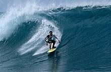
South Nias Regency is paradise for surfers with 4 surfer beaches:
- Sorake Beach (Lagundri Bay) is second best in the world after Hawaii Beach for surfing. It has 5 level of waves which only occurs here.[9] Located in Luahagundre Maniamolo district with wave height maximum 3-4 meters and it depends on the wind.
- Beaches in Pulau Pulau Batu, Pulau Pulau Batu Barat, and Pulau Pulau Batu Utara districts with wave height maximum 8-9 meters, but have only limited infrastructures.[10]
References
- Badan Pusat Statistik, Jakarta, 2018.
- Biro Pusat Statistik, Jakarta, 2011.
- Badan Pusat Statistik, Jakarta, 2018.
- DKCS (Dinas Kependudukan dan Catatan Sipil), Jakarta, 2019.
- Biro Pusat Statistik, Jakarta, 2011.
- Badan Pusat Statistik, Jakarta, 2018.
- Biro Pusat Statistik, Jakarta, 2011.
- Badan Pusat Statistik, Jakarta, 2018.
- "Pantai Sorake, Idaman Peselancar Dunia". December 7, 2011.
- Irwan Arfa (September 18, 2016). "South Nias, Paradise for Surfers".