South Carolina Highway 336
South Carolina Highway 336 (SC 336) is a primary state highway in the U.S. state of South Carolina. It serves to connect Ridgeland with nearby U.S. Route 321 (US 321) and SC 462.
| ||||
|---|---|---|---|---|
| ||||
| Route information | ||||
| Maintained by SCDOT | ||||
| Length | 13.5 mi[1] (21.7 km) | |||
| Existed | 1938–present | |||
| Major junctions | ||||
| West end | ||||
| East end | ||||
| Location | ||||
| Counties | Jasper | |||
| Highway system | ||||
| ||||

Route description

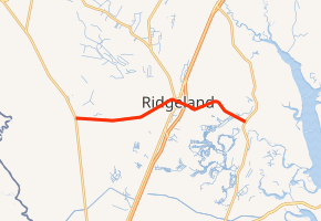
SC 336 is a two-lane rural highway predominantly throughout its route. Starting at US 321 in Tillman, it goes east into downtown Ridgeland, then continuing east to SC 462 in Old House where it ends. Its routing east of Interstate 95 (I-95) takes a series of turns, making the highway's routing a bit disjointing.[1] Travelers wishing to bypass Ridgeland can continue straight on Smiths Crossing (S-27-29), saving a 0.5 miles (0.80 km) and a few minutes, though large trucks are restricted from using that route.
The highway connects to several historic places, including Jasper County Courthouse, Church of the Holy Trinity, Honey Hill-Boyd's Neck Battlefield, White Hall Plantation House Ruins and the Old House Plantation.
History
The highway was established in 1938 as a new primary routing from SC 33 (today's US 321) in Tillman, to US 17/SC 36 (today's US 17/US 278) in Ridgeland.[2] In 1997, it replaced US 278 from Ridgeland to SC 462 in Old House.[3]
Junction list
The entire route is in Jasper County.
| Location | mi[1] | km | Destinations | Notes | |
|---|---|---|---|---|---|
| Tillman | 0.0 | 0.0 | |||
| Ridgeland | 7.8 | 12.6 | |||
| 8.4 | 13.5 | I-95 exit 21 | |||
| Old House | 13.5 | 21.7 | |||
| 1.000 mi = 1.609 km; 1.000 km = 0.621 mi | |||||
References
- Google (November 17, 2013). "South Carolina Highway 336" (Map). Google Maps. Google. Retrieved November 17, 2013.
- General Highway Map, Jasper County, South Carolina (PDF) (Map). Cartography by SCDOT. South Carolina Department of Transportation. 1940. Retrieved November 16, 2013.
- General Highway System - Jasper County (PDF) (Map). South Carolina Department of Transportation. June 2005. Retrieved November 17, 2013.
External links

- Mapmikey's South Carolina Highways Page: SC 330-339