Slow Train
"Slow Train" is a song by the British duo Flanders and Swann, written in July 1963.[1] It laments the closure of railway stations and lines brought about by the Beeching cuts in the 1960s, and also the passing of a way of life.[2]
| "Slow Train" | |
|---|---|
 Writers Flanders and Swann | |
| Song by Flanders and Swann | |
| Written | 1963 |
| Genre | List song; Train song |
| Composer(s) | Donald Swann |
| Lyricist(s) | Michael Flanders |
Lyrics
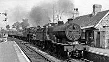
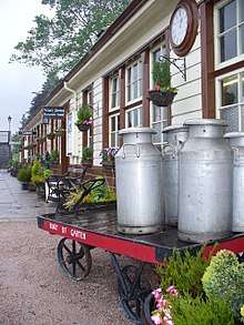

"Slow Train" takes the form of an elegiac list song of railway stations which has been likened to a litany.[3] Its evocation of quiet, rural stations is highly romanticised and uses imagery such as the presence of a station cat or milk churns on a platform to illustrate a "less hurried way of life" that is about to vanish:[2]
No churns, no porter, no cat on a seat,
At Chorlton-cum-Hardy or Chester-le-Street.
The strength of "Slow Train" is considered to lie in its list of "achingly bucolic" names of rural halts. The nostalgically poetic tone of Flanders' lyrics has been likened to Edward Thomas's 1914 poem, "Adlestrop", which wistfully evokes a fleeting scene of Adlestrop railway station in Gloucestershire.[4]
Although most of the stations mentioned in the song were earmarked for closure under the Beeching cuts, a number of the stations were spared closure: Chester-le-Street, Formby, Ambergate and Arram all remain open, and Gorton and Openshaw also survives, now called Gorton. Some lines referred to in the song have since been re-opened, notably Chorlton-cum-Hardy which closed in January 1967, but re-opened in July 2011 as Chorlton tram stop.
Selby and Goole were not threatened by Beeching, though the line from Selby to Goole mentioned in the song was closed to passengers. The other line mentioned, from St Erth to St Ives[note 1] was reprieved, and both stations remain open.
Michael Flanders' delivery of the lyrics seems to imply that Formby Four Crosses and Armley Moor Arram were station names, but in both cases he combined two consecutive names from an alphabetical list of stations. It has been suggested that he took the names of the stations from The Guardian, explaining at least some of the discrepancies between the names in the songs and the names of the stations.[5]
Other versions
In 2004, Canadian classical quartet Quartetto Gelato released a themed album called Quartetto Gelato Travels the Orient Express, celebrating the original journey of Orient Express and featuring music from London to Istanbul. The album begins with a rendition of "Slow Train", with the final lines changed to reflect the route of the Orient Express.
A version of "The Slow Train" by the King's Singers is on electronica duo Lemon Jelly's track "'76 aka The Slow Train", combined with a cover of the Albert Hammond song "I'm a Train" also performed by the King's Singers. A live version by Stackridge was included in its 2009 DVD 4x4.
Michael Williams' book "On the Slow Train" takes its name from the song. It celebrates 12 of the most beautiful and historic journeys in Britain that were saved from the Beeching cuts, including famous routes such as the Settle-Carlisle line and less well-known pleasures, such as the four-hour Preston to Carlisle route along the remote Cumbrian coastline.[6]
English folk singer-songwriter Frank Turner included a version of the song on his 2011 compilation album, The Second Three Years.
List of stations referred to in the lyrics
Where appropriate, the correct name of the station is shown in brackets.
- Ten of the 31 stations were open in 2012, with five others on lines still open.
- Trouble House Halt opened in 1959, shortly before Beeching became BR chairman.
- Re-opening of the line through Cheslyn Hay in 1989 included a new Landywood station, half a mile to the south.
- Kirby Muxloe is regularly proposed for re-opening with the freight-only Ivanhoe line remaining between Leicester and Burton however a scheme re-appraisal by Scott Wilson in 2009 suggested there was little likelihood of the line reopening to passengers.[11]
- Littleton and Badsey, Chittening Platform and Armley Moor are on lines still open. Chittening and Armley are in the Bristol and Leeds urban areas, and are proposed for re-opening.
Notes
- While the Cornish St Ives was the one to which Flanders is referring, St Ives, Cambridgeshire on the Great Eastern Railway between Cambridge and Huntingdon was closed by Beeching.
- Re-opened in July 2011 as Chorlton, on Manchester Metrolink.
- Both Selby and Goole remain open, but the line between them, referred to in the song, closed in 1964.[10]
References
- "The musical slow train". BBC Cambridgeshire. 3 October 2008. Retrieved 6 June 2018.
- Williams, Michael (2011). On the Slow Train: Twelve Great British Railway Journeys. Random House. p. 1. ISBN 9781848092082. Retrieved 5 June 2018.
- Williams, Michael (2011). On the Slow Train Again. Random House. p. 1. ISBN 9781409051244. Retrieved 5 June 2018.
- Bray, Christopher (2014). 1965: The Year Modern Britain was Born. Simon and Schuster. p. 80. ISBN 9780857202796. Retrieved 5 June 2018.
- "Littleton and Badsey Station (Revisited)". 21 January 2003. Retrieved 3 December 2009.
- "Michael Williams: So much pain in our love of the train". The Independent. London. 3 April 2010. Retrieved 14 February 2011.
- Pre-Grouping Atlas, page 15
- Pre-Grouping Atlas, page 16
- Catford, Nick (20 April 2010). "Long Stanton". Disused Stations. Retrieved 16 December 2011.
- Suggitt, Gordon. "Chapter 11: Around Selby". Lost Railways of North & East Yorkshire. Countryside Books. pp. 124–126.
- "Re-opening rail line 'too costly'". Leicester Mercury. 9 September 2009. Archived from the original on 14 October 2009.
Bibliography
- British Railways Pre-grouping Atlas and Gazetteer. Ian Allan. 1988. ISBN 0-7110-0320-3.
- Dewick, Tony. Rail Atlas 1890.
- Jowett, Alan (1989). Jowett's Railway Atlas of Great Britain & Ireland. Patrick Stephens Ltd. ISBN 1-85260-086-1.