Signy Research Station
Signy Research Station (originally Station H)[1] is an Antarctic research base on Signy Island, run by the British Antarctic Survey.
Signy Research Station | |
|---|---|
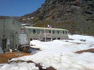 Signy Research Station in 2006 | |
 Flag | |
.svg.png) Rothera Research Station location within the British Antarctic Territory in Antarctica | |
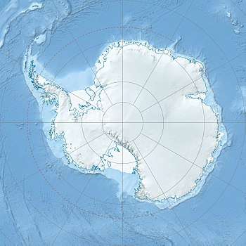 Signy Research Station Location of Signy Research Station in Antarctica | |
| Coordinates: 60°42′29″S 45°35′42″W | |
| Country | |
| British Overseas Territory | British Antarctic Territory |
| Location in Antarctica | Signy Island |
| Administered by | British Antarctic Survey |
| Established | 1947 |
| Elevation | 5 m (16 ft) |
| Population | |
| • Total |
|
| Type | Seasonal |
| Period | Summer |
| Status | Operational |
| Website | www.antarctica.ac.uk |
History
Signy was first occupied in 1947 when a three-man meteorological station was established in Factory Cove above the old whaling station.[2][1] It was the second research base on the South Orkney Islands (after the Argentine Orcadas Base in 1903). In 1955, a new hut, Tønsberg House was built on the site of the whaling station. In 1963, it was turned into a laboratory for biological research. Initially operated year-round, since 1995/6 the station has been open from November to April each year (southern hemisphere summer).
Facilities
Today, the base has four buildings with capacity for 8 people.[2] The main building, Sørlle House (named after the whaling captain Petter Sørlle, who himself named Signy Island), provides living accommodation and laboratories. The other buildings are for storage and provision of power and water services. There are also four small huts around the island.
Research
Marine and terrestrial biology is carried out at Signy, particularly looking at the effects of climate change on the southern ocean ecosystems. Three species of penguin (Adélie, chinstrap and gentoo) are monitored at the base.[2]
To continue an original time series of visual sea ice observations after the station became summer-only, an automated sea ice camera now operates all year around,[3] providing a continuous record of sea ice extent near the station for over 50 years.
Climate
| Climate data for Signy Research Station, 6 m asl (1971–2000 normals) | |||||||||||||
|---|---|---|---|---|---|---|---|---|---|---|---|---|---|
| Month | Jan | Feb | Mar | Apr | May | Jun | Jul | Aug | Sep | Oct | Nov | Dec | Year |
| Record high °C (°F) | 19.8 (67.6) |
16.2 (61.2) |
13.3 (55.9) |
4.6 (40.3) |
4.9 (40.8) |
3.9 (39.0) |
7.4 (45.3) |
3.3 (37.9) |
4.7 (40.5) |
6.6 (43.9) |
6.6 (43.9) |
3.6 (38.5) |
19.8 (67.6) |
| Average high °C (°F) | 6.1 (43.0) |
6.4 (43.5) |
6.3 (43.3) |
0.7 (33.3) |
0.2 (32.4) |
−2.0 (28.4) |
−4.6 (23.7) |
−5.0 (23.0) |
0.9 (33.6) |
1.1 (34.0) |
2.0 (35.6) |
1.6 (34.9) |
1.1 (34.1) |
| Daily mean °C (°F) | 1.2 (34.2) |
3.9 (39.0) |
3.1 (37.6) |
−1.8 (28.8) |
−2.1 (28.2) |
−6.9 (19.6) |
−7.4 (18.7) |
−10.3 (13.5) |
−2.9 (26.8) |
−1.6 (29.1) |
−0.8 (30.6) |
−0.1 (31.8) |
−2.1 (28.2) |
| Average low °C (°F) | −0.7 (30.7) |
1.4 (34.5) |
−0.2 (31.6) |
−4.3 (24.3) |
−4.4 (24.1) |
−11.7 (10.9) |
−10.1 (13.8) |
−15.6 (3.9) |
−6.6 (20.1) |
−4.2 (24.4) |
−3.5 (25.7) |
−1.9 (28.6) |
−5.1 (22.7) |
| Record low °C (°F) | −1.5 (29.3) |
1.0 (33.8) |
−4.4 (24.1) |
−8.8 (16.2) |
−11.8 (10.8) |
−27.8 (−18.0) |
−27.7 (−17.9) |
−25.4 (−13.7) |
−13.9 (7.0) |
−8.7 (16.3) |
−9.0 (15.8) |
−3.8 (25.2) |
−27.8 (−18.0) |
| Average precipitation mm (inches) | 33.7 (1.33) |
— | 72.6 (2.86) |
6.6 (0.26) |
10.3 (0.41) |
2.6 (0.10) |
5.7 (0.22) |
4.7 (0.19) |
140.0 (5.51) |
— | — | 14.1 (0.56) |
— |
| Average precipitation days (≥ 1 mm) | 11.63 | — | 26.57 | — | 5.17 | — | — | 1.82 | 10.00 | — | — | 5.64 | — |
| Source 1: Météo climat stats[4] | |||||||||||||
| Source 2: Météo Climat [5] | |||||||||||||
References
- "History of Signy (Station H) - British Antarctic Survey". Retrieved 2019-05-13.
- "Signy Research Station". British Antarctic Survey. Archived from the original on 18 September 2008. Retrieved 19 February 2011.
- "Signy Sea Ice Camera". British Antarctic Survey. Archived from the original on 12 November 2010. Retrieved 19 February 2011.
- "Moyennes 1981-2010 Antarctique" (in French). Retrieved 11 November 2019.
- "Météo Climat stats for Ile Signy". Météo Climat. Retrieved 11 November 2019.
External links
- Official website British Antarctic Survey
- BAS Signy Research Station
- BAS Signy Research Station Images at BAS
- COMNAP Antarctic Facilities
- COMNAP Antarctic Facilities Map
| Wikimedia Commons has media related to Signy Station. |
| General |
| .svg.png) |
|---|---|---|
| Geographic regions | ||
| Waterways | ||
| Famous explorers | ||