Shadow Lake, Washington
Shadow Lake is a census-designated place (CDP) in King County, Washington, United States. The population was 2,262 at the 2010 census.[2]
Shadow Lake, Washington | |
|---|---|
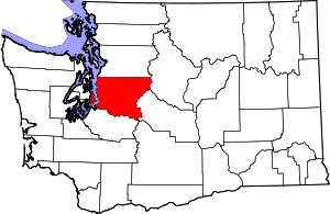
 Shadow Lake Location in Washington and the United States  Shadow Lake Shadow Lake (the United States) | |
| Coordinates: 47°24′6″N 122°4′10″W | |
| Country | United States |
| State | Washington |
| County | King |
| Area | |
| • Total | 5.33 sq mi (13.81 km2) |
| • Land | 5.19 sq mi (13.44 km2) |
| • Water | 0.14 sq mi (0.37 km2) |
| Elevation | 550 ft (170 m) |
| Population (2010) | |
| • Total | 2,262 |
| • Density | 436.0/sq mi (168.3/km2) |
| Time zone | UTC-8 (Pacific (PST)) |
| • Summer (DST) | UTC-7 (PDT) |
| GNIS feature ID | 2585035[1] |
| FIPS code | 53-63545 |
Geography
Shadow Lake is located in southwestern King County at 47°24′06″N 122°04′10″W (47.401561, -122.069418).[3] It is bordered to the southeast by the city of Maple Valley, to the south by the city of Covington, and to the north by the Maple Heights-Lake Desire CDP. SE Petrovitsky Road forms the northeast border of the community. Shadow Lake is 22 miles (35 km) southeast of downtown Seattle and 26 miles (42 km) northeast of Tacoma.
According to the United States Census Bureau, the CDP has a total area of 5.3 square miles (13.8 km2), of which 5.2 square miles (13.4 km2) are land and 0.2 square miles (0.4 km2), or 2.67%, are water.[2] The namesake Shadow Lake water body is in the western part of the CDP.
Tahoma National Cemetery is located at (47.38722, -122.09354) in the southwest part of the CDP, off SE 240th Street.
References
- "Shadow Lake Census Designated Place". Geographic Names Information System. United States Geological Survey.
- "Geographic Identifiers: 2010 Census Summary File 1 (G001), Shadow Lake CDP, Washington". American FactFinder. U.S. Census Bureau. Archived from the original on February 13, 2020. Retrieved June 21, 2019.
- "US Gazetteer files: 2010, 2000, and 1990". United States Census Bureau. 2011-02-12. Retrieved 2011-04-23.
Municipalities and communities of King County, Washington, United States | ||
|---|---|---|
| Cities |
|  King County map |
| Towns | ||
| CDPs |
| |
| Unincorporated communities | ||
| Indian reservation |
| |
| Ghost towns | ||
| Footnotes | ‡This populated place also has portions in an adjacent county or counties | |