Secane, Pennsylvania
Secane is an unincorporated community in Ridley Township and Upper Darby Township, Delaware County, Pennsylvania, United States.[1] At its center is retail shopping and a commuter rail station. Immediately surrounding the center are four large garden apartment complexes surrounded by single-family homes. The neighborhood has a curvilinear/cul-de-sac street pattern typical of post-World War II residential development.[2] It is located in two school districts, Upper Darby and Ridley.
Secane, Pennsylvania | |
|---|---|
 Secane Location within the U.S. state of Pennsylvania  Secane Secane (the United States) | |
| Coordinates: 39°54′50″N 75°18′08″W | |
| Country | United States |
| State | Pennsylvania |
| County | Delaware |
| Townships | Upper Darby, Ridley |
| Time zone | UTC-5 (Eastern (EST)) |
| • Summer (DST) | UTC-4 (EDT) |
| ZIP code | 19018 |
| Area code(s) | 610 and 484 |
History
Secane is named after a 17th-century Algonquin leader.[3] In July 1683, William Penn purchased the lands between Chester Creek and the Schuylkill River from the Unami chiefs Secane and Icquoquehan.[4][5]
Secane was the home of the Tully-Secane Country Club. However, the Archdiocese of Philadelphia converted the golf course into Our Lady of Fatima Church.[6]
Geography
Secane is divided between the municipalities of Ridley Township, and Upper Darby Township, and is often confused with Clifton Heights, since the two communities share the same the ZIP code.
The Muckinipattis Creek initiates in Secane and runs south through the community until it meets with Darby Creek in Tinicum Township.[7]
Education
Ridley School District serves houses in Ridley Township. Upper Darby School District serves houses in Upper Darby Township.
Our Lady of Angels Regional School in Ridley Township, near Morton, is the area Catholic school. It formed in 2012 from a merger of Our Lady of Fatima in Secane and Ridley Township and Our Lady of Perpetual Help in Ridley Township.[8]
Demographics
Secane has a population of almost 24000 and was farmland before it was developed into a residential area in the 20th century.
Transportation
Three main roads run through the town, Providence Road, South Avenue and Franklin Avenue, which leads to Kedron Avenue (Route 420).
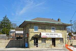
Secane station is a stop on the SEPTA Regional Rail Media/Elwyn Line, which runs west from Philadelphia to Elwyn.[9] The station was previously a stop on the Pennsylvania Railroad and known as Spring Hill.[10]
Notable people
- Pat Croce, former Philadelphia 76ers owner[11]
- Joe Sestak, retired U.S. Navy officer and congressman
References
- "Geographic Names Information System". geonames.usgs.gov/. Retrieved 3 November 2017.
- "Making Secane a Walkable Community" (PDF). www.dvrpc.org. Retrieved 3 November 2017.
- Bright, William (2004). Native American Placenames in the United States. Norman: University of Oklahoma Press. p. 428. ISBN 0-8061-3576-X. Retrieved 3 November 2017.
- Hanna, Charles Augustus (1911). The Wilderness Trail. New York: G.P. Putnams's Sons. p. 97. Retrieved 4 November 2017.
secane.
- Myers, Albert Cook (1970). William Penn's Own Account of the Lenni Lenape or Delaware Indians. Moorestown, NJ: Middle Atlantic Press. p. 25. ISBN 0-912608-13-7. Retrieved 4 November 2017.
- Silverman, Jeff. "Here today, gone tomorrow - The Philadelphia Area's Lost Golf Courses" (PDF). www.trenhamgolfhistory.org. Retrieved 4 November 2017.
- "Feature Detail Report for Muckinipattis Creek". www.geonames.usgs.gov. Retrieved 4 November 2017.
- "2012 Catholic grade school consolidations/closings". Catholicphilly.com. 2012-07-15. Retrieved 2020-04-22.
- "Secane Station". www.septa.org. Retrieved 3 November 2017.
- Springfield Township, Delaware County. Charleston, SC: Arcadia Publishing. 2004. ISBN 9781439629017. Retrieved 4 November 2017.
- Lyon, Bill (2000). I Feel Great and You Will Too!. New York: Simon & Schuster. p. 46. ISBN 0-7432-2213-X. Retrieved 3 November 2017.
Founded 1736 | ||
| Communities |
|   |
| Education | ||
| Historic Sites |
| |
| Infrastructure | ||
| Regional Rail Stations |
| |
| Trolley/Subway Station |
| |
Municipalities and communities of Delaware County, Pennsylvania, United States | ||
|---|---|---|
| City | 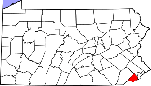 | |
| Boroughs | ||
| Townships | ||
| CDPs | ||
| Unincorporated communities |
| |
| Ghost town | ||
| Footnotes | ‡This populated place also has portions in an adjacent county or counties | |