Santa Monica, Surigao del Norte
Santa Monica, officially the Municipality of Santa Monica (Surigaonon: Lungsod nan Santa Monica; Tagalog: Bayan ng Santa Monica), is a 5th class municipality in the province of Surigao del Norte, Philippines. According to the 2015 census, it has a population of 8,808 people.[3]
Santa Monica | |
|---|---|
| Municipality of Santa Monica | |
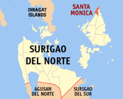 Map of Surigao del Norte with Santa Monica highlighted | |
OpenStreetMap 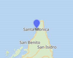
| |
.svg.png) Santa Monica Location within the Philippines | |
| Coordinates: 10°01′12″N 126°02′17″E | |
| Country | |
| Region | Caraga (Region XIII) |
| Province | Surigao del Norte |
| District | 1st District |
| Barangays | 11 (see Barangays) |
| Government | |
| • Type | Sangguniang Bayan |
| • Mayor | Fernando N. Dolar |
| • Vice Mayor | Arwela A. Dolar |
| • Congressman | Francisco Jose F. Matugas II |
| • Electorate | 7,996 voters (2019) |
| Area | |
| • Total | 39.19 km2 (15.13 sq mi) |
| Population (2015 census)[3] | |
| • Total | 8,808 |
| • Density | 220/km2 (580/sq mi) |
| • Households | 1,974 |
| Economy | |
| • Income class | 5th municipal income class |
| • Poverty incidence | 33.05% (2015)[4] |
| • Revenue (₱) | 44,142,068.60 (2016) |
| Time zone | UTC+8 (PST) |
| ZIP code | 8422 |
| PSGC | |
| IDD : area code | +63 (0)86 |
| Climate type | tropical rainforest climate |
| Native languages | Surigaonon Agusan language Cebuano Tagalog |
It is also known as Sapao. Santa Monica is one of the two northernmost towns of Siargao Island. The other is the municipality of Burgos.
Barangays
Santa Monica is politically subdivided into 11 barangays.
Demographics
| Year | Pop. | ±% p.a. |
|---|---|---|
| 1903 | 1,462 | — |
| 1960 | 6,522 | +2.66% |
| 1970 | 5,438 | −1.80% |
| 1975 | 5,993 | +1.97% |
| 1980 | 6,272 | +0.91% |
| 1990 | 7,167 | +1.34% |
| 1995 | 7,219 | +0.14% |
| 2000 | 7,757 | +1.55% |
| 2007 | 7,916 | +0.28% |
| 2010 | 8,715 | +3.56% |
| 2015 | 8,808 | +0.20% |
| Source: Philippine Statistics Authority[3][5][6][7] | ||
Climate
| Climate data for Santa Monica, Surigao del Norte | |||||||||||||
|---|---|---|---|---|---|---|---|---|---|---|---|---|---|
| Month | Jan | Feb | Mar | Apr | May | Jun | Jul | Aug | Sep | Oct | Nov | Dec | Year |
| Average high °C (°F) | 27 (81) |
27 (81) |
28 (82) |
29 (84) |
30 (86) |
29 (84) |
30 (86) |
30 (86) |
30 (86) |
29 (84) |
29 (84) |
28 (82) |
29 (84) |
| Average low °C (°F) | 23 (73) |
23 (73) |
23 (73) |
24 (75) |
24 (75) |
24 (75) |
24 (75) |
24 (75) |
24 (75) |
24 (75) |
24 (75) |
23 (73) |
24 (74) |
| Average precipitation mm (inches) | 161 (6.3) |
132 (5.2) |
112 (4.4) |
87 (3.4) |
136 (5.4) |
169 (6.7) |
146 (5.7) |
148 (5.8) |
132 (5.2) |
156 (6.1) |
176 (6.9) |
170 (6.7) |
1,725 (67.8) |
| Average rainy days | 21.0 | 16.8 | 18.5 | 18.2 | 24.9 | 27.7 | 28.4 | 27.0 | 26.1 | 27.6 | 24.6 | 22.0 | 282.8 |
| Source: Meteoblue [8] | |||||||||||||
References
- "Municipality". Quezon City, Philippines: Department of the Interior and Local Government. Retrieved 31 May 2013.
- "Province: Surigao del Norte". PSGC Interactive. Quezon City, Philippines: Philippine Statistics Authority. Retrieved 12 November 2016.
- Census of Population (2015). "Caraga". Total Population by Province, City, Municipality and Barangay. PSA. Retrieved 20 June 2016.
- "PSA releases the 2015 Municipal and City Level Poverty Estimates". Quezon City, Philippines. Retrieved 12 October 2019.
- Census of Population and Housing (2010). "Caraga". Total Population by Province, City, Municipality and Barangay. NSO. Retrieved 29 June 2016.
- Censuses of Population (1903–2007). "Caraga". Table 1. Population Enumerated in Various Censuses by Province/Highly Urbanized City: 1903 to 2007. NSO.
- "Province of Surigao del Norte". Municipality Population Data. Local Water Utilities Administration Research Division. Retrieved 17 December 2016.
- "Santa Monica: Average Temperatures and Rainfall". Meteoblue. Retrieved 20 November 2019.
External links
- Santa Monica Profile at PhilAtlas.com
- Philippine Standard Geographic Code
- Philippine Census Information
- Local Governance Performance Management System
Places adjacent to Santa Monica, Surigao del Norte | ||||||||||
|---|---|---|---|---|---|---|---|---|---|---|
| ||||||||||
Surigao City (capital) | |
| Municipalities | |
| Component city | |
This article is issued from Wikipedia. The text is licensed under Creative Commons - Attribution - Sharealike. Additional terms may apply for the media files.