Sainte-Catherine-de-Fierbois
Sainte-Catherine-de-Fierbois is a commune in the Indre-et-Loire department in central France.
Sainte-Catherine-de-Fierbois | |
|---|---|
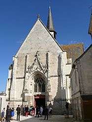 The church of Sainte-Catherine, in Sainte-Catherine-de-Fierbois | |
.svg.png) Coat of arms | |
Location of Sainte-Catherine-de-Fierbois 
| |
 Sainte-Catherine-de-Fierbois  Sainte-Catherine-de-Fierbois | |
| Coordinates: 47°09′30″N 0°39′16″E | |
| Country | France |
| Region | Centre-Val de Loire |
| Department | Indre-et-Loire |
| Arrondissement | Tours |
| Canton | Sainte-Maure-de-Touraine |
| Government | |
| • Mayor (2008–2014) | Popelier Vincent |
| Area 1 | 15.49 km2 (5.98 sq mi) |
| Population (2017-01-01)[1] | 761 |
| • Density | 49/km2 (130/sq mi) |
| Time zone | UTC+01:00 (CET) |
| • Summer (DST) | UTC+02:00 (CEST) |
| INSEE/Postal code | 37212 /37800 |
| Elevation | 92–129 m (302–423 ft) |
| 1 French Land Register data, which excludes lakes, ponds, glaciers > 1 km2 (0.386 sq mi or 247 acres) and river estuaries. | |
Population
| Year | Pop. | ±% |
|---|---|---|
| 1793 | 507 | — |
| 1800 | 509 | +0.4% |
| 1806 | 543 | +6.7% |
| 1821 | 582 | +7.2% |
| 1831 | 556 | −4.5% |
| 1836 | 618 | +11.2% |
| 1841 | 610 | −1.3% |
| 1846 | 640 | +4.9% |
| 1851 | 694 | +8.4% |
| 1856 | 699 | +0.7% |
| 1861 | 667 | −4.6% |
| 1866 | 635 | −4.8% |
| 1872 | 596 | −6.1% |
| 1876 | 562 | −5.7% |
| 1881 | 570 | +1.4% |
| 1886 | 570 | +0.0% |
| 1891 | 574 | +0.7% |
| 1896 | 570 | −0.7% |
| 1901 | 618 | +8.4% |
| 1906 | 620 | +0.3% |
| 1911 | 657 | +6.0% |
| 1921 | 551 | −16.1% |
| 1926 | 542 | −1.6% |
| 1931 | 514 | −5.2% |
| 1936 | 510 | −0.8% |
| 1946 | 511 | +0.2% |
| 1954 | 506 | −1.0% |
| 1962 | 436 | −13.8% |
| 1968 | 499 | +14.4% |
| 1975 | 529 | +6.0% |
| 1982 | 484 | −8.5% |
| 1990 | 539 | +11.4% |
| 1999 | 611 | +13.4% |
| 2006 | 648 | +6.1% |
| 2009 | 657 | +1.4% |
References
- "Populations légales 2017". INSEE. Retrieved 6 January 2020.
| Wikimedia Commons has media related to Sainte-Catherine-de-Fierbois. |
| Authority control |
|
|---|
This article is issued from Wikipedia. The text is licensed under Creative Commons - Attribution - Sharealike. Additional terms may apply for the media files.