Saint-Laurent, Haute-Garonne
Saint-Laurent, also referred to as Saint-Laurent-sur-Save, is a commune in the Haute-Garonne department in southwestern France.
Saint-Laurent | |
|---|---|
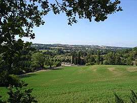 A general view of Saint-Laurent | |
_projet_v2.svg.png) Coat of arms | |
Location of Saint-Laurent 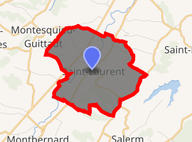
| |
 Saint-Laurent  Saint-Laurent | |
| Coordinates: 43°19′36″N 0°47′59″E | |
| Country | France |
| Region | Occitanie |
| Department | Haute-Garonne |
| Arrondissement | Saint-Gaudens |
| Canton | Cazères |
| Intercommunality | Portes du Comminges |
| Government | |
| • Mayor (2008–2014) | André Clerc |
| Area 1 | 9.39 km2 (3.63 sq mi) |
| Population (2017-01-01)[1] | 181 |
| • Density | 19/km2 (50/sq mi) |
| Time zone | UTC+01:00 (CET) |
| • Summer (DST) | UTC+02:00 (CEST) |
| INSEE/Postal code | 31494 /31230 |
| Elevation | 211–341 m (692–1,119 ft) |
| 1 French Land Register data, which excludes lakes, ponds, glaciers > 1 km2 (0.386 sq mi or 247 acres) and river estuaries. | |
Population
| Year | Pop. | ±% |
|---|---|---|
| 1793 | 518 | — |
| 1800 | 490 | −5.4% |
| 1806 | 603 | +23.1% |
| 1821 | 576 | −4.5% |
| 1831 | 626 | +8.7% |
| 1836 | 655 | +4.6% |
| 1841 | 642 | −2.0% |
| 1846 | 657 | +2.3% |
| 1851 | 625 | −4.9% |
| 1856 | 584 | −6.6% |
| 1861 | 601 | +2.9% |
| 1866 | 570 | −5.2% |
| 1872 | 543 | −4.7% |
| 1876 | 547 | +0.7% |
| 1881 | 522 | −4.6% |
| 1886 | 511 | −2.1% |
| 1891 | 505 | −1.2% |
| 1896 | 448 | −11.3% |
| 1901 | 447 | −0.2% |
| 1906 | 415 | −7.2% |
| 1911 | 424 | +2.2% |
| 1921 | 330 | −22.2% |
| 1926 | 322 | −2.4% |
| 1931 | 320 | −0.6% |
| 1936 | 302 | −5.6% |
| 1946 | 284 | −6.0% |
| 1954 | 249 | −12.3% |
| 1962 | 228 | −8.4% |
| 1968 | 205 | −10.1% |
| 1975 | 177 | −13.7% |
| 1982 | 136 | −23.2% |
| 1990 | 141 | +3.7% |
| 1999 | 157 | +11.3% |
| 2008 | 161 | +2.5% |
External links
| Wikimedia Commons has media related to Saint-Laurent (Haute-Garonne). |
| Authority control |
|---|
This article is issued from Wikipedia. The text is licensed under Creative Commons - Attribution - Sharealike. Additional terms may apply for the media files.