Ruppach-Goldhausen
Ruppach-Goldhausen is an Ortsgemeinde – a community belonging to a Verbandsgemeinde – in the Westerwaldkreis in Rhineland-Palatinate, Germany.
Ruppach-Goldhausen | |
|---|---|
 Coat of arms | |
Location of Ruppach-Goldhausen within Westerwaldkreis district 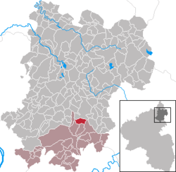 | |
 Ruppach-Goldhausen 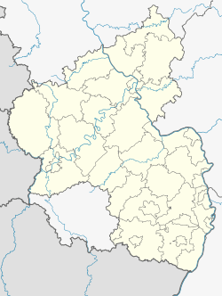 Ruppach-Goldhausen | |
| Coordinates: 50°27′48″N 7°52′49″E | |
| Country | Germany |
| State | Rhineland-Palatinate |
| District | Westerwaldkreis |
| Municipal assoc. | Montabaur |
| Government | |
| • Mayor | Klaus Henkes |
| Area | |
| • Total | 4.41 km2 (1.70 sq mi) |
| Elevation | 270 m (890 ft) |
| Population (2018-12-31)[1] | |
| • Total | 1,253 |
| • Density | 280/km2 (740/sq mi) |
| Time zone | CET/CEST (UTC+1/+2) |
| Postal codes | 56412 |
| Dialling codes | 02602 |
| Vehicle registration | WW |
| Website | www.vg-montabaur.de |
Geography
Location
The community lies in the Westerwald north of Montabaur on the edge of the Nassau Nature Park. Through the community flows the Ahrbach. The community belongs to the Verbandsgemeinde of Montabaur, a kind of collective municipality. Its seat is in the like-named town.
History
In 1289, Goldhausen had its first documentary mention as Golthusen.
Amalgamations
The two communities of Ruppach and Goldhausen merged in 1969 in the course of administrative reform.
Politics
Community council
The council is made up of 16 council members who were elected in a majority vote in a municipal election on 7 June 2009.
Coat of arms
The upper part of the community's arms represent the union of the coats of arms borne by the Lords of Reifenberg and the nobles of Nassau-Spurkenburg. Serving as the model for the arms’ design was the former court seal of Ruppach from 1596. The step-shaped lower part of the arms symbolizes clay quarrying and the wavy fess stands for the Ahrbach.
Economy and infrastructure
Transport
The nearest Autobahn interchange is Montabaur on the A 3 (Cologne–Frankfurt), some 3 km away. The nearest InterCityExpress stops are Montabaur station on the Cologne-Frankfurt high-speed rail line and Koblenz on the Rechte Rheinstrecke. Goldhausen has a station on the Lower Westerwald Railway Unterwesterwaldbahn from Limburg to Siershahn.
References
- "Bevölkerungsstand 2018 - Gemeindeebene". Statistisches Landesamt Rheinland-Pfalz (in German). 2019.
External links
| Authority control |
|
|---|