Rumdoodle Peak
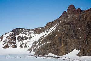
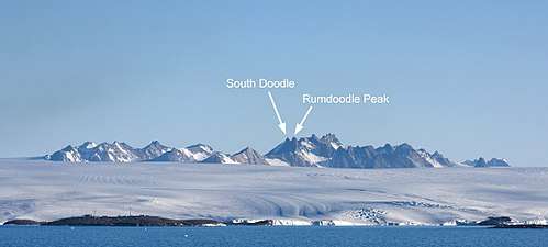
Rumdoodle Peak, elevation 875 m ASL, is a small but prominent mountain in the north-western part of the North Masson Range in Antarctica, near Mawson Station.
| Rumdoodle Peak | |
|---|---|
 Rumdoodle Peak with the small green hut visible at the base | |
| Highest point | |
| Elevation | 875 m (2,871 ft) |
| Coordinates | 67°46′17.1″S 62°49′48.7″E |
| Geography | |
| Location | Mac. Robertson Land Antarctica |
| Parent range | North Masson Range |
Rumdoodle Skiway | |||||||||||
|---|---|---|---|---|---|---|---|---|---|---|---|
| Summary | |||||||||||
| Airport type | Private | ||||||||||
| Location | Mawson Station | ||||||||||
| Time zone | (+5) | ||||||||||
| Elevation AMSL | 1,605 ft / 489 m | ||||||||||
| Coordinates | 67°44′58″S 62°45′56″E | ||||||||||
| Map | |||||||||||
 Rumdoodle Skiway Location of airfield in Antarctica | |||||||||||
| Runways | |||||||||||
| |||||||||||
It was named, around 1960, after the previously fictitious peak featured in the book The Ascent of Rum Doodle.
There is a small hut at the base (altitude 498m ASL), sleeping 5 people, and two permanently frozen lakes alongside, named Rumdoodle Lake and Lassitude Lake.
See also
- Airports in Antarctica
References
- "Rumdoodle Skiway". Airport Nav Finder. Retrieved October 17, 2018.
External links

The North Masson range viewed from offshore, with Mawson Station visible in the foreground
This article is issued from Wikipedia. The text is licensed under Creative Commons - Attribution - Sharealike. Additional terms may apply for the media files.
.svg.png)