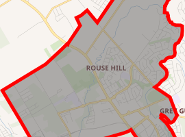
Rouse Hill, New South Wales
Rouse Hill is a suburb of Sydney, in the state of New South Wales, Australia. Rouse Hill is located in the Hills District, 43 kilometres north-west of the Sydney central business district and 19 kilometres north-west of the Parramatta central business district. It is in the local government areas of The Hills Shire and City of Blacktown. Rouse Hill Town Centre is at the heart of the suburb, which contains a busy Town Square.
| Rouse Hill Sydney, New South Wales | |||||||||||||||
|---|---|---|---|---|---|---|---|---|---|---|---|---|---|---|---|
_Main_Street_Shopping_Centre.JPG) Main Street, Rouse Hill Town Centre shopping centre, 2010 | |||||||||||||||
| |||||||||||||||
| Population | 7,965 (2016 census)[1] | ||||||||||||||
| Established | 1802 | ||||||||||||||
| Postcode(s) | 2155 | ||||||||||||||
| Location |
| ||||||||||||||
| LGA(s) |
| ||||||||||||||
| State electorate(s) | Castle Hill, Riverstone | ||||||||||||||
| Federal Division(s) | Greenway, Mitchell | ||||||||||||||
| |||||||||||||||
History
Rouse Hill encompasses what was originally known as the Village of Aberdour along with the area originally known as Vinegar Hill following the convict rebellion of 1804. Rouse Hill was serviced by the first ferry service in the colony, the Rose Hill Packet. Vinegar Hill Post Office opened on 1 October 1857 and was renamed Rouse Hill on 13 April 1858.[2][3] The new name was chosen after the estate of Richard Rouse (1774-1852), a prominent free settler who arrived in the colony in 1801. His first grant here was in 1802 and his second grant was in 1816. Governor Lachlan Macquarie suggested the estate be called Rouse Hill.[4]
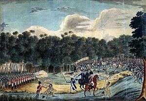
Rouse Hill is noteworthy in Australian history as the site of the main battle during an Irish rebellion, known as the Castle Hill rebellion or the second Battle of Vinegar Hill. On 4 March 1804, Irish convicts including political prisoners transported for participating in the Irish Rebellion of 1798, broke out of the Government Farm at Castle Hill, aiming to seize control of the area and to capture Parramatta. The uprising was crushed by the military authorities at Rouse Hill the following day with much loss of life. Many of the participants in the rebellion were summarily executed. The exact site of the Battle is uncertain but a monument with a plaque commemorating the event can be seen within Castlebrook Lawn Cemetery on Windsor Road in Kellyville Ridge.[5]
Heritage listings
Mungerie_House_031.jpg)
Rouse Hill has a number of heritage-listed sites, including:
- Hunting Lodge, Rouse Hill[6]
- Royal Oak Inn, Rouse Hill[7]
- Mungerie House, Rouse Hill[8]
Rouse Hill House
.jpg)
Richard Rouse built his Australian Georgian home, Rouse Hill House, from 1813-18. Service wings and an arcaded courtyard were added c. 1863. The simple, geometric layout of the garden is probably the oldest surviving in Australia. The house, its immediate surviving estate and outbuildings including stables designed by John Horbury Hunt, is now a house museum cared for by Sydney Living Museums,[9] and is listed on the New South Wales State Heritage Register,[10] and the former Register of the National Estate.[11] Much of the family memorabilia has been preserved, including dolls, clothes and writings of the two girls, Nina (1875-1968) and Kathleen Rouse (1878-1932). These form a unique and fascinating record of late-Victorian Australian childhood,[12] and inspired Ursula Dubosarsky's prize-winning novel "Abyssinia".[13]
Commercial area
Rouse Hill Town Centre built on the old golf course is the town centre, owned and managed by The GPT Group, is located at the intersection of White Hart Drive and Windsor Roads. The first stage opened in September 2007 with the launch of the town centre on 6 March 2008. The first stage comprises Woolworths and Coles supermarkets, a food terrace, and 80 specialty stores . The second stage comprises Big W, Target, Reading Cinemas, an additional 130 specialty stores, a Community Centre, Library, Medical Centre, commercial and residential accommodation and the Secret Garden. The development has been integrated with the North-West T-way and Rouse Hill railway station opened in 2019.
Rouse Hill Village Centre which opened in 1999, is a small shopping centre located on Windsor Road. This complex features a major discount supermarket chain selling packaged groceries and perishables, as well as specialty shops and restaurants. The Terrace is another small shopping centre which was opened on Panmure Street in 2004.
Churches
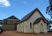
- Christ Church, an Anglican church located on Windsor Road, was built in 1863 for the United Church of England and Ireland (Warren et al. 2006). It was a church, school and the centre of most community events. In 2008, a Ministry and Education Centre opened alongside the restored Christ Church and the old hall built in 1908.[14] In 1875, the school was relocated from the church and established as Rouse Hill Public School on the corner of Windsor Road and Annangrove Road, and then relocated once again in 2003 to its present site.
Education
Transport
Rouse Hill is bisected by Windsor Road, which is now a major 4-lane road running from North Parramatta north-west to Windsor. Most residents of Rouse Hill are reliant on private cars for transport, with a high number of households having two or more cars.
Hillsbus provides services to Sydney CBD, North Sydney, Parramatta, Macquarie Park, and Castle Hill. Busways provides services to Blacktown, Riverstone and Castle Hill. Hillsbus also provides weekday services from Rouse Hill to Windsor. In September 2007, the North-West T-way opened, providing a bus rapid transit service to Parramatta railway station.
The Sydney Metro Northwest provides high frequency rail services to Chatswood. Two stations are located inside Rouse Hill: Rouse Hill and Tallawong, the line's terminus.
Demographics
At the 2016 census, the suburb of Rouse Hill recorded a population of 7,965 people. Of these:[1]
- Age distribution: Residents had a distinct bias towards young families compared to the country overall. The median age was 34 years, compared to the national median of 38 years. Children aged under 15 years made up 26.2% of the population (national average is 18.7%) and people aged 65 years and over made up 7.6% of the population (national average is 15.8%).
- Ethnic diversity: 68.8% were born in Australia, which is higher than the national average of 66.7%; the next most common countries of birth were Philippines 3.6%, England 3.3%, China 2.4%, India 2.2% and South Africa 1.9%. 74.1% of people only spoke English at home. Other languages spoken at home included Mandarin 3.2%, Tagalog 2.2%, Arabic 1.6% and Hindi 1.4%.
- Religion: The most common responses for religion were Catholic 32.5%, No Religion 18.5% and Anglican 18.3%.
- Finances: The median household weekly income was $2,401, compared to the national median of $1,438. This difference is also reflected in real estate, with the median mortgage payment being $2,600 per month, compared to the national median of $1,755.
- Transport: On the day of the Census, 11.9% of employed people traveled to work on public transport and 73.4% by car (either as driver or as passenger).
- Housing: 59.5% of occupied private dwellings were separate houses, 33.7% were semi-detached. The average household size was 3.4 people.
References
- Australian Bureau of Statistics (27 June 2017). "Rouse Hill (State Suburb)". 2016 Census QuickStats. Retrieved 2 November 2017.

- Premier Postal History. "Post Office List". Retrieved 1 June 2012.
- Warren, J.; Wilson, P.; Pullen, N. (2006). Rouse Hill Village: a step back in time. The Hills District Historical Society Inc. ISBN 0-9577602-3-X
- "Rouse Hill". Geographical Names Register (GNR) of NSW. Geographical Names Board of New South Wales. Retrieved 4 January 2007.
- "Vinegar Hill". Blacktown City Council. Archived from the original on 22 July 2008. Retrieved 2 July 2008.
- "Hunting Lodge (former)". New South Wales State Heritage Register. Office of Environment and Heritage. H00632. Retrieved 18 May 2018.
- "Royal Oak Inn (former)". New South Wales State Heritage Register. Office of Environment and Heritage. H00698. Retrieved 18 May 2018.
- "Mungerie House". New South Wales Heritage Database. Office of Environment and Heritage. Retrieved 10 October 2019.
- "Rouse Hill House & Farm". Sydney Living Museums. Office of Environment and Heritage, Government of New South Wales. Archived from the original on 4 October 2017. Retrieved 6 October 2017.
- "Rouse Hill House and Farm". New South Wales State Heritage Register. Office of Environment and Heritage. Retrieved 6 October 2017.
- The Heritage of Australia, Macmillan Company, 1981, p.2/12
- http://www.hht.net.au/discover/highlights/articles/kathleen_rouses_dolls_clothes_dressed-up_for_the_camera Archived 24 March 2012 at the Wayback Machine Retrieved 11 July 2012
- http://www.penguin.com.au/products/9780143300519/abyssinia Archived 3 October 2010 at the Wayback Machine retrieved 11 July 2012
- Percy, Natasha (28 April 2008). "People know we're here!". SydneyAnglicans.net. Archived from the original on 5 July 2008. Retrieved 2 July 2008.
- "Ironbark Ridge Public School". NSW Department of Education. Archived from the original on 29 July 2018. Retrieved 2 July 2008.
- "Our Lady of the Angels Primary School". Our Lady of the Angels Primary. Archived from the original on 13 March 2019. Retrieved 1 August 2012.
- "Rouse Hill Anglican College". Rouse Hill Anglican College. Archived from the original on 5 March 2016. Retrieved 2 July 2008.
- "Rouse Hill High School". NSW Department of Education. Archived from the original on 11 November 2012. Retrieved 1 August 2012.
- "Rouse Hill Public School". NSW Department of Education. Archived from the original on 17 March 2018. Retrieved 2 July 2008.
External links
| Wikimedia Commons has media related to Rouse Hill, New South Wales. |
- Terri McCormack (2008). "Rouse Hill Estate". Dictionary of Sydney. Retrieved 29 September 2015. [CC-By-SA]