River Hamble
The River Hamble is a river in Hampshire, England. It rises near Bishop's Waltham and flows for some 7.5 miles (12 km) through Botley, Bursledon, and Swanwick before entering Southampton Water near Hamble-le-Rice and Warsash.
| River Hamble | |
|---|---|
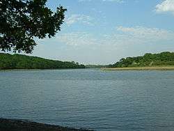 The River Hamble looking upstream towards Botley from Fosters Copse. Dock Copse can be seen on the left bank. Bloomfield Copse is on the right bank. | |
| Location | |
| Country | England |
| Physical characteristics | |
| Source | |
| • location | Bishops Waltham, Hampshire. |
| Mouth | |
• location | Southampton Water |
| Length | 26 km (16 mi) |
The Hamble is tidal for approximately half its length and is navigable in its lower reaches, which have facilitated shipbuilding activities since medieval times. Leisure craft are still built there today.
One of these builders was Luke & co, later Luke Bros, a reputed yard at Hamble from around 1890 to 1945.
The river, and its shipbuilding yards have also been used for military purposes, particularly during World War II.
Its lower reaches are popular for boating, being known throughout the sailing world as The Heart of British Yachting.
Bishops Waltham to Botley (non-tidal)
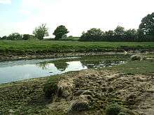
From its source near Bishop's Waltham, the river flows in a generally southerly direction picking up several small tributary streams before reaching Botley, the site of an ancient watermill.
Botley to Bursledon (tidal) - historic sites
Below Botley, the river becomes tidal and navigable. It gains strength from adjoining streams, draining the surrounding areas of Hedge End, Curdridge, Shedfield, and Burridge.[1]
This section has been extensively used for medieval shipbuilding, using timber grown locally in the neighbouring woods. Nearby Kings Copse, formerly Kings Forest,[2] indicates the former importance of this area.
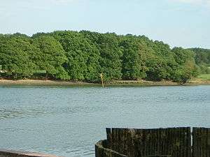
The river's west bank can be accessed from Manor Farm Country Park, where it is possible to walk through Dock Copse[1] and Fosters Copse.[1] At extreme low tide, it is just possible to see the remains of the wreck of Henry V's 15th century warship Grace Dieu. This section of the river was also home to HMS Cricket during World War II.
Some 2 miles (3 km) south of Botley, the river passes between the villages of Bursledon and Lower Swanwick and is crossed by the M27 motorway, the Portsmouth to Southampton railway line, and the A27 road on three substantial bridges.
Bursledon to Hamble (tidal) - modern playground
A further 2 miles (3 km) south of Bursledon, the river flows between the villages of Hamble-le-Rice and Warsash before entering Southampton Water.[3]
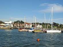
A passenger ferry crosses the river between Hamble-le-Rice and Warsash, forming an important link in the Solent Way and E9 European Coastal Path. The river is also the location for several large marinas, the largest being the Port Hamble Marina and boat yards, situated on both banks as far upstream as Bursledon.[3]
In the 1970s and 80s the large number of yachts in this area resulted in significant pollution from tributyltin used in anti fowling paints.[4] By 1988 the area had the highest known level of tributyltin pollution in the UK.[4] With the banning of tributyltin for vessels under 25 meters the levels of tributyltin began to decline towards levels considered harmless.[4]
See also
- Rivers of the United Kingdom
References
- Ordnance Survey
- Joyce Blyth. The changing face of Hedge End
- Ordnance Survey (2005). OS Explorer Map 119 - Meon Valley, Portsmouth, Gosport & Fareham. ISBN 0-319-23596-3.
- Tubbs, Colin (1999). The Ecology, Conservation and History of the Solent. Packard Publishing. pp. 109–110. ISBN 1853411167.
External links
| Wikimedia Commons has media related to River Hamble. |
- Walks in the Hamble Valley
- Map sources for River Hamble for the source of the River Hamble.
- Map sources for River Hamble for the mouth of the River Hamble.
- The River Hamble Harbour Authority
- Port Hamble Marina
Settlements in the Borough of Eastleigh | ||
|---|---|---|
 | ||
| Main rivers |
|  |
|---|---|---|
| Canals and Navigations | ||
| Ordinary watercourses | ||
| Lakes, ponds and wetlands | ||
| Coast | ||
Categories: Rivers, Canals | ||