Rann of Kutch
The Rann of Kutch is a large area of salt marshes that span the border between Pakistan and India. It is located mostly in Gujarat (primarily the Kutch district), India and in some parts of Sindh, Pakistan. It is divided into the Great Rann and Little Rann.
Rann of Kutch કચ્છનું રણ | |
|---|---|
Natural region | |
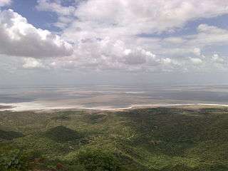 Landscape in the Rann of Kutch | |
 Rann of Kutch seasonal salt marsh ecoregion | |
| Country | India & Pakistan |

Geography
The Rann of Kutch is located in the Thar Desert. It is a biogeographic area in the Indian state of Gujarat, specifically Kutch district, for which it is named. Some parts cross into the Pakistani province of Sindh. The word Rann means "salt marsh", which alternates with medak's, elevated pieces of land where vegetation grows. Kori Creek and Sir Creek are located in the area, which form parts of the Indus River Delta.
The region is seasonally marshy. The marsh covers around 26,000 square kilometres (10,000 square miles) and is positioned between the Gulf of Kutch and the mouth of the Indus River in southern Pakistan. Many rivers located in Rajasthan and Gujarat flow into the Rann of Kutch. These are: Luni, Bhuki, Bharud, Nara, Kharod, Banas, Saraswati, Rupen, Bambhan and Machchhu.[1]
Ecology

The Rann of Kutch is the only large flooded grasslands zone in the Indo-Malayan region.[2] The area has desert on one side and the sea on the other enables various ecosystems, including mangroves and desert vegetation.[3] Its grassland and deserts are home to forms of wildlife that have adapted to its often harsh conditions. These include endemic and endangered animal and plant species.[4]
History
The History of the Rann of Kutch began with early neolithic settlements. It was later inhabited by the Indus Valley Civilization as well as the Maurya and Gupta empires of India.
Indus Valley Period
The people of the Indus civilization appear to have settled in the Rann of Kutch around 3500 BCE.[5] The Indus city of Dholavira, the largest Indus site in India, is located in the Rann of Kutch. This city was built on the Tropic of Cancer, possibly indicating that Dholavira's inhabitants were skilled in astronomy.[6]

The Rann of Kutch also contained the industrial site of Khirasara, where a warehouse was found.[7]
Many Indologists such as A. S. Gaur and Mani Murali hold the view that the Rann of Kutch was, rather than the salt marsh that it is today, a navigable archipelago at the time of the Indus Civilization. The Indus Civilization was known to have an extensive martime trade system, so it has been proposed by Gaur et. al. that there were perhaps ports in the Rann of Kutch.[8]
Imperial Indian Period
The Rann of Kutch was a part of both the Maurya[9] and Gupta[10] empires of India.
Colonial and Modern Periods
The Rann of Kutch came under the control of the British Raj, who imposed a ban on salt harvesting. This ban was protested and overturned by Indian activist Mahatma Gandi.[11] More recently, the residents of the Rann of Kutch began holding the Rann Utsav festival, a 3-month long carnival, which marks the peak tourist season.[12]
.jpg)
See also
- Arid Forest Research Institute (AFRI),animals, birds, lion{{}}
References
- "Rivers of Gujarat in Kutch region". guj-nwrws.gujarat.gov.in, Government of Gujarat. Retrieved 13 March 2018.
- WWF - Rann of Kutch Flooded Grasslands Archived 2014-07-22 at the Wayback Machine
- Negi, Sharad Singh (1996). Biosphere reserves in India: landuse, biodiversity and conservation. Indus Publishing. p. 221. ISBN 9788173870439.
- Sharma, R.P. (10 November 2011). The Indian forester, Volume 127, Issues 7-12. University of Minnesota.
- Sengupta, Torsa. "Did the Harappan settlement of Dholavira (India) collapse during the onset of Meghalayan stage drought?". Wiley Online Library. Retrieved 15 July 2020.
- Gopinath, P. "Ruins on the Tropic of Cancer". The Hindu. Retrieved 15 July 2020.
- Subramanian, T. "Excavations reveal Khirsara a major industrial hub of Harappan era". The Hindu. Retrieved 15 July 2020.
- Gaur, A (September 2013). "Was the Rann of Kachchh (Kutch) navigable during the Harappan times (Mid-Holocene)? An archaeological perspective". Retrieved 15 July 2020. Cite journal requires
|journal=(help) - "The Mauryan Empire of Ancient India". Time Maps.
- "Gupta Empire". Ancient History Encyclopedia. Retrieved 15 July 2020.
- Dalton; Gandhi, Mahatma. Selected Political Writings.
- Eden, Noronha. "Immerse yourself in Gujarat's Rann Utsav". Femina In. Retrieved 15 July 2020.
External links
- Southern Asia: Western India into Pakistan - Ecoregions
- Global Species : Ecoregion : Rann of Kutch seasonal salt marsh
| National parks |
|
|---|---|
| Wildlife sanctuaries | |
| Game reserves |
|
| Protected wetlands |
|
| Natural monuments |
|
| Protected forests | |
| Biosphere reserves |
|