Rampart–St. Claude Streetcar Line
The Rampart–St. Claude Streetcar line is a historic streetcar line in New Orleans, Louisiana. It is operated by the New Orleans Regional Transit Authority (RTA). It is the newest streetcar line in the system, as it opened on October 2, 2016, with the total length of the line being 1.6 mi (2.6 km).[1] The line is officially designated Route 49 and is denoted with a gold color on most RTA publications.
| Rampart–St. Claude Streetcar line | ||||||||||||||||||||||||||||||||||||||||||||||||||||||||||||||||||||||||||||||||||||||||||
|---|---|---|---|---|---|---|---|---|---|---|---|---|---|---|---|---|---|---|---|---|---|---|---|---|---|---|---|---|---|---|---|---|---|---|---|---|---|---|---|---|---|---|---|---|---|---|---|---|---|---|---|---|---|---|---|---|---|---|---|---|---|---|---|---|---|---|---|---|---|---|---|---|---|---|---|---|---|---|---|---|---|---|---|---|---|---|---|---|---|---|
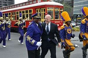 Mayor Mitch Landrieu with the St. Augustine Purple Knights Marching Band at opening celebrations for the new Loyola Avenue streetcar line on January 28, 2013. | ||||||||||||||||||||||||||||||||||||||||||||||||||||||||||||||||||||||||||||||||||||||||||
| Overview | ||||||||||||||||||||||||||||||||||||||||||||||||||||||||||||||||||||||||||||||||||||||||||
| Type | Heritage streetcar | |||||||||||||||||||||||||||||||||||||||||||||||||||||||||||||||||||||||||||||||||||||||||
| System | New Orleans Regional Transit Authority | |||||||||||||||||||||||||||||||||||||||||||||||||||||||||||||||||||||||||||||||||||||||||
| Status | Operational | |||||||||||||||||||||||||||||||||||||||||||||||||||||||||||||||||||||||||||||||||||||||||
| Locale | New Orleans, Louisiana | |||||||||||||||||||||||||||||||||||||||||||||||||||||||||||||||||||||||||||||||||||||||||
| Termini | UPT Elysian Fields | |||||||||||||||||||||||||||||||||||||||||||||||||||||||||||||||||||||||||||||||||||||||||
| Services | Route 49 | |||||||||||||||||||||||||||||||||||||||||||||||||||||||||||||||||||||||||||||||||||||||||
| Operation | ||||||||||||||||||||||||||||||||||||||||||||||||||||||||||||||||||||||||||||||||||||||||||
| Opened | January 28, 2013 (as Loyola-UPT line) October 2, 2016 (current line configuration) | |||||||||||||||||||||||||||||||||||||||||||||||||||||||||||||||||||||||||||||||||||||||||
| Owner | New Orleans Regional Transit Authority | |||||||||||||||||||||||||||||||||||||||||||||||||||||||||||||||||||||||||||||||||||||||||
| Operator(s) | New Orleans Regional Transit Authority | |||||||||||||||||||||||||||||||||||||||||||||||||||||||||||||||||||||||||||||||||||||||||
| Character | Runs in traffic lanes next to the neutral ground | |||||||||||||||||||||||||||||||||||||||||||||||||||||||||||||||||||||||||||||||||||||||||
| Technical | ||||||||||||||||||||||||||||||||||||||||||||||||||||||||||||||||||||||||||||||||||||||||||
| Line length | 1.6 mi (2.6 km) (total) | |||||||||||||||||||||||||||||||||||||||||||||||||||||||||||||||||||||||||||||||||||||||||
| Track gauge | 5 ft 2 1⁄2 in (1,588 mm) | |||||||||||||||||||||||||||||||||||||||||||||||||||||||||||||||||||||||||||||||||||||||||
| Electrification | 600 V DC trolley wire | |||||||||||||||||||||||||||||||||||||||||||||||||||||||||||||||||||||||||||||||||||||||||
| ||||||||||||||||||||||||||||||||||||||||||||||||||||||||||||||||||||||||||||||||||||||||||
Before the line was rerouted to its current route, it was originally called the Loyola-UPT Streetcar line, which opened on January 28, 2013.[2] Construction started in August 2011, and the line was opened in time for New Orleans' hosting of Super Bowl XLVII.[3][4] It was reconfigured to the current Rampart–St. Claude line as part of the Rampart Streetcar construction project that began in April 2015.
Route description
The Rampart–St. Claude Streetcar line begins at the New Orleans Union Passenger Terminal (UPT) where it connects with RTA bus routes, Amtrak, and Greyhound Lines. From there, it runs for 0.8 mi (1.3 km) on Loyola Avenue in the New Orleans Central Business District to Canal Street. With the exception of only two blocks, this portion of the line does not operate on neutral ground, but rather on the inside traffic lanes. It is also unique in New Orleans in that the streetcar stops are built to light rail system standards as opposed to typical streetcar stops that utilize a simple concrete platform sometimes with a bench and/or a canopy. The route continues on Canal Street for one block before turning onto North Rampart Street, primarily with trackage operating in mixed street traffic. It continues through the French Quarter and Tremé neighborhoods, then continues onto St. Claude Avenue to its terminus at Elysian Fields Avenue. The line operates the same type of Von Dullen cars as the Canal Street line. It features solar powered passenger shelters along Loyola Avenue.[5]
The former Loyola-UPT line went down Canal to Harrah's at the Mississippi River, and on weekends, it continued further down the Riverfront tracks to the French Market terminal at Esplanade Avenue.[6][7]
Although RTA literature consistently refers to this line as Rampart–St. Claude, the route signs displayed on the streetcars often show the name Loyola-UPT.
Operation
The Rampart–St. Claude line normally operates between approximately 6 a.m. and midnight, with a frequency of every 20 minutes throughout service times.
However, on October 12, 2019, a building under construction at the corner of Canal Street and N. Rampart Street collapsed, blocking the line (see Hard Rock Hotel Collapse). Currently, the portion of the line between Canal and Elysian Fields cannot be served by rail. The Loyola-UPT portion of the line, along Loyola Avenue, is served by Canal-Cemeteries streetcars 24 hours a day.
Stop listing

From Marigny to UPT
| Stop | Neighborhood(s) | Other streetcar lines | Notes |
|---|---|---|---|
| By way of St. Claude Avenue | |||
| Elysian Fields Avenue | Marigny, Seventh Ward | Northern terminus of line. Serves Frenchmen Entertainment District. | |
| Pauger Street | Marigny, Seventh Ward | ||
| By way of McShane Place (two blocks), then North Rampart Street | |||
| Esplanade Avenue | French Quarter, Marigny, Seventh Ward, Tremé | ||
| Ursulines Street | French Quarter, Tremé | ||
| St. Ann Street | French Quarter, Tremé | Serves Louis Armstrong Park (including Congo Square, Mahalia Jackson Theater for the Performing Arts, Municipal Auditorium and New Orleans Jazz National Historical Park). | |
| Conti Street | French Quarter, Iberville | ||
| Canal and Rampart Streets | Downtown, Central Business District, French Quarter | Major transfer point to Canal Streetcar Line and many RTA buses serving downtown Serves Saenger Theatre. | |
| By way of Elk Place from Canal to Tulane, then Loyola Avenue to UPT | |||
| Tulane Avenue | Downtown, Central Business District, Biomedical District | Serves LSU Health Sciences Center New Orleans, New Orleans Public Library, and Tulane Hospital. Loyola Avenue transitions from Elk Place. | |
| Poydras Street | Downtown, Central Business District | Serves Champions Square, City Hall, Civil District Court, Duncan Plaza, Mercedes-Benz Superdome, and Smoothie King Center. | |
| Hyatt Regency New Orleans Hotel (inbound only) | Downtown, Central Business Street | Serves Hyatt Regency New Orleans Hotel. Stop located near Girod Street in the Bloch Cancer Survivors Plaza. Linked by walkway leading from South Rampart and Lafayette Streets. | |
| Julia Street | Downtown, Central Business District | ||
| Union Passenger Terminal (UPT) | Downtown, Central Business District | Connects with RTA buses (no direct connection at UPT), Amtrak, and Greyhound Lines. | |
References
- http://www.nola.com/politics/index.ssf/2016/09/all_aboard_north_rampart_st_cl.html
- "Streetcars in New Orleans". NewOrleansOnline.com. The Official Tourism Site of the City of New Orleans. 2013. Retrieved 16 July 2013.
- "Loyola Avenue streetcar line construction ramps up". NOLA.com. NOLA Media Group. 16 August 2011. Retrieved 10 April 2014.
- Mark Strassmann (Reporter) (1 February 2013). The streetcar makes a comeback in New Orleans (News Report). New Orleans: CBS News. Retrieved 10 April 2014.
- LaHood, Ray (28 January 2013). "Loyola Streetcar a winner for New Orleans". Fast Lane. United States Department of Transportation. Retrieved 10 April 2014.
- Buchanan, Susan (22 January 2013). "Loyola streetcar starts to roll". The Louisiana Weekly. Retrieved 10 April 2014.
- Maldonado, Charles (28 January 2013). "Photos: Loyola Streetcar grand opening ceremony and inaugural ride". BestofNewOrleans.com. Gambit. Retrieved 10 April 2014.