Radzyń Podlaski County
Radzyń Podlaski County (Polish: powiat radzyński) is a unit of territorial administration and local government (powiat) in Lublin Voivodeship, eastern Poland. It was established on January 1, 1999, as a result of the Polish local government reforms passed in 1998. Its administrative seat and only town is Radzyń Podlaski, which lies 60 kilometres (37 mi) north of the regional capital Lublin.
Radzyń Podlaski County Powiat radzyński | |
|---|---|
 Flag  Coat of arms | |
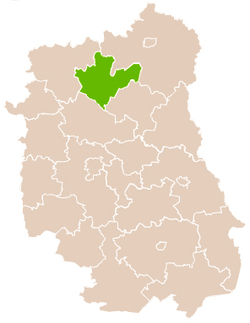 Location within the voivodeship | |
| Coordinates (Radzyń Podlaski): 51°46′58″N 22°37′27″E | |
| Country | |
| Voivodeship | Lublin |
| Seat | Radzyń Podlaski |
| Gminas | |
| Area | |
| • Total | 965.21 km2 (372.67 sq mi) |
| Population (2006) | |
| • Total | 61,445 |
| • Density | 64/km2 (160/sq mi) |
| • Urban | 16,133 |
| • Rural | 45,312 |
| Car plates | LRA |
| Website | http://www.powiatradzynski.pl/ |
The county covers an area of 965.21 square kilometres (372.7 sq mi). As of 2006, its total population is 61,445, including a population of 16,133 Radzyń Podlaski and a rural population of 45,312.
Neighbouring counties
Radzyń Podlaski County is bordered by Biała Podlaska County to the north-east, Parczew County to the south-east, Lubartów County to the south and Łuków County to the north-west.
Administrative division
The county is subdivided into eight gminas (one urban and seven rural). These are listed in the following table, in descending order of population.
| Gmina | Type | Area (km²) |
Population (2006) |
Seat |
| Radzyń Podlaski | urban | 19.3 | 16,133 | |
| Gmina Kąkolewnica | rural | 147.7 | 8,459 | Kąkolewnica |
| Gmina Radzyń Podlaski | rural | 155.2 | 8,028 | Radzyń Podlaski * |
| Gmina Wohyń | rural | 178.2 | 7,221 | Wohyń |
| Gmina Borki | rural | 111.8 | 6,166 | Borki |
| Gmina Ulan-Majorat | rural | 107.8 | 6,062 | Ulan-Majorat |
| Gmina Komarówka Podlaska | rural | 137.6 | 4,728 | Komarówka Podlaska |
| Gmina Czemierniki | rural | 107.7 | 4,648 | Czemierniki |
| * seat not part of the gmina | ||||
References
| Seat |
| |
|---|---|---|
| Rural gminas | ||
| City counties |
|  |
|---|---|---|
| Land counties | ||