Qatana
Qatana (Arabic: قطنا) is a city in southern Syria, administratively part of the Qatana District of Rif Dimashq Governorate. Qatana has an altitude of 879 meters. According to the Syria Central Bureau of Statistics, the city had a population of 33,996 in the 2004 census. It is the administrative center of the Qatana Subdistrict, which contained 20 localities with a collective population of 147,451 in 2004.[1]
Qatana قطنا | |
|---|---|
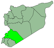
 Qatana Location in Syria | |
| Coordinates: 33°25′54″N 36°5′33″E | |
| Country | |
| Governorate | Rif Dimashq |
| District | Qatana |
| Subdistrict | Qatana |
| Elevation | 879 m (2,884 ft) |
| Population (2004 census)[1] | |
| • Total | 33,996 |
History
In the early 13th-century, during Ayyubid rule, Yaqut al-Hamawi noted Katana as "one of the villages of Damascus".[2]
In 1838, it was noted as a predominantly Sunni Muslim village.[3]
Prior to the Syrian Civil War, during which there have been armed confrontations in Qatana, the city had a mixed population of Sunni Muslims (65%), Christians (20%) and Alawites (15%). The Alawites were relatively recent arrivals, who emigrated to the city during the 1970s.[4] In December 2012, it was reported that 28 government checkpoints control this multi-ethnic regime stronghold.[5] On 15 October 2013, there was shelling emanating from Turba checkpoint and the Baath School area.
Climate
Qatana has a cold semi-arid climate (Köppen climate classification: BSk). Rainfall is higher in winter than in summer. The average annual temperature in Qatana is 16.1 °C (61.0 °F). About 296 mm (11.65 in) of precipitation falls annually.
| Climate data for Qatana | |||||||||||||
|---|---|---|---|---|---|---|---|---|---|---|---|---|---|
| Month | Jan | Feb | Mar | Apr | May | Jun | Jul | Aug | Sep | Oct | Nov | Dec | Year |
| Average high °C (°F) | 10.9 (51.6) |
12.6 (54.7) |
16.1 (61.0) |
20.9 (69.6) |
26.5 (79.7) |
30.9 (87.6) |
32.8 (91.0) |
33.5 (92.3) |
30.2 (86.4) |
25.8 (78.4) |
19.0 (66.2) |
13.3 (55.9) |
22.7 (72.9) |
| Average low °C (°F) | 2.0 (35.6) |
2.6 (36.7) |
4.8 (40.6) |
8.0 (46.4) |
11.6 (52.9) |
14.9 (58.8) |
16.5 (61.7) |
16.8 (62.2) |
14.4 (57.9) |
11.4 (52.5) |
7.2 (45.0) |
3.9 (39.0) |
9.5 (49.1) |
| Average precipitation mm (inches) | 73 (2.9) |
55 (2.2) |
33 (1.3) |
16 (0.6) |
11 (0.4) |
0 (0) |
0 (0) |
0 (0) |
0 (0) |
11 (0.4) |
35 (1.4) |
62 (2.4) |
296 (11.7) |
| Source: Climate-Data.org,Climate data | |||||||||||||
References
- General Census of Population and Housing 2004. Syria Central Bureau of Statistics (CBS). Rif Dimashq Governorate. (in Arabic)
- Le Strange, 1890, p. 483
- Smith, in Robinson and Smith, 1841, vol 3, 2nd appendix, p. 148
- Starr, Stephen (2012-07-04). "Syrian divisions in full force". Asia Times Online.
- "أبو علي - عضو قيادة الثورة في قطنا". SyriaTomorrow. 26 December 2012. Retrieved 26 December 2012.
Bibliography
- Le Strange, G. (1890). Palestine Under the Moslems: A Description of Syria and the Holy Land from A.D. 650 to 1500. London: Committee of the Palestine Exploration Fund. OCLC 1004386.
- Robinson, E.; Smith, E. (1841). Biblical Researches in Palestine, Mount Sinai and Arabia Petraea: A Journal of Travels in the year 1838. 3. Boston: Crocker & Brewster.