Prądnik Czerwony
Prądnik Czerwony is one of 18 districts of Kraków; known as Dzielnica III (District 3), located in the northern part of the city. The name Prądnik Czerwony comes from a village of same name (first mentioned in 1105) that is now a part of the district.[1]
Prądnik Czerwony | |
|---|---|
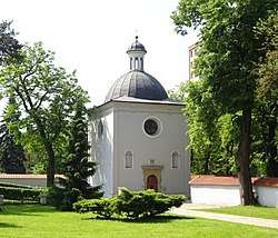 Historic Chapel of St. John the Baptist | |
 Location of Prądnik Czerwony within Kraków | |
| Coordinates: 50°4′59.63″N 19°58′7.84″E | |
| Country | |
| Voivodeship | Lesser Poland |
| County/City | Kraków |
| Government | |
| • President | Aniela Dirks |
| Area | |
| • Total | 6.44 km2 (2.49 sq mi) |
| Population (2014) | |
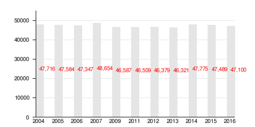
| • Total | 47,775 |
| • Density | 7,400/km2 (19,000/sq mi) |
| Time zone | UTC+1 (CET) |
| • Summer (DST) | UTC+2 (CEST) |
| Area code(s) | +48 12 |
| Website | http://www.dzielnica3.krakow.pl |
According to the Central Statistical Office data, the district's area is 6.44 square kilometres (2.49 square miles) and 47 775 people inhabit Prądnik Czerwony.[2]
Subdivisions of Prądnik Czerwony
Prądnik Czerwony is divided into smaller subdivisions (osiedles). Here's a list of them.[1]
- Olsza
- Olsza II
- Prądnik Czerwony
- Rakowice
- Śliczna
- Ugorek
- Warszawskie
- Wieczysta
- Akacjowa
Population
References
- Staff writer (2017), History of Prądnik Czerwony. Drop-down menu: "O Dzielnicy." Official website, Rada i Zarząd Dzielnicy III, Prądnik Czerwony (in Polish).
- "Information about Prądnik Czerwony district". Biuletyn Informacji Publicznej. Retrieved 30 August 2017.
This article is issued from Wikipedia. The text is licensed under Creative Commons - Attribution - Sharealike. Additional terms may apply for the media files.