Postal codes in Trinidad and Tobago
In 2012, the government of Trinidad and Tobago approved the introduction of postal codes starting later that same year. In addition to the postal code implementation the country has embarked on a nationwide address improvement initiative adopting the Universal Postal Union (UPU) S-42 international standard of addressing. The UPU is an arm of the United Nations and is the coordinating body of postal services worldwide. The intent of this exercise is to correct poor addressing in Trinidad & Tobago and assign to each address a six-digit postal code. This change will result in the following:
- • All buildings will carry a building/civic number
- • Numbering will be sequential and logical
- • Less reliance on mile markers, lot numbers, lamp post numbers and "corner of" in addressing.
It is currently launched in the boroughs of Chaguanas, Point Fortin and Arima; Sangre Grande, Penal–Debe, Mayaro-Rio Claro, San Fernando and Princes Town regional corporations; and Tobago.
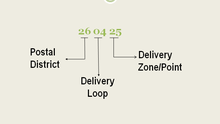
As announced in 2012, each code would be a six-digit number, with the first two digits indicating one of 72 postal districts (64 in Trinidad, eight in Tobago).[1] Although it was piloted in Point Fortin in 2013[2] and later tested in four other Trinidad communities, as well as the island of Tobago, government officials said in 2016 that the required mapping was not yet complete, and the legislative framework for the changes had never been implemented.[3]
Example
According to Trinidad and Tobago Newsday, an envelope using the postcode may be properly addressed thus:[1]
- Mr James Doe
- 71 Beechwood Road
- Goodside Gardens
- DIEGO MARTIN 150110
- TRINIDAD AND TOBAGO
- _______________________
- Mr Jane Doe
- 22 Poinsettia Crescent
- Westmoorings
- CARENAGE 110702
- TRINIDAD AND TOBAGO
In the example above, the digits "15" refer to the delivery office in Diego Martin; "01" to a certain delivery route served by that office; and "10" to a certain building or zone along that delivery route.[4]
History
Trinidad and Tobago Postal Corporation officially launched the system March 28, 2012, promising that residents and businesses would receive a postcard informing them of their new postal code "before the end of the year".[1] In May 2016, the estimated completion date was given as "within a year or two."[3]
In May 2011, TTPost said it planned to develop a postal code system in part because it is more efficient to sort mail using automated sorting machines, and in part because many areas in Trinidad and Tobago use vague or imprecise descriptive addresses based on "word of mouth and the use of landmarks". TTPost also said it also hoped develop a universal standard for addressing.[5]
“Many of our business and residential addresses regularly include features such as lamp pole numbers, street addresses without a building number, lot numbers and mile markers and the phrase ‘corner of’ as means of identification," said Trinidad and Tobago Public Utilities Minister Nizam Baksh in 2013. “Such elements may be easily understood by those living in a community, but they not only make mail delivery tedious, but can also slow down the response of fire service and ambulance personnel who are responding to an emergency in the area."[2]
Postal workers' representatives noted that along with increased efficiency in mail sorting, the system is expected to accompany a loss in mail sorter jobs. Advocates of the postal code system touted several side benefits. Classifying every address in a geographical postal code could aid in statistical analysis of crime and health care, for example.[1]
List of Postal Districts
District Code and Name (First two (2) digits of the postal code)


- 30 Arima
- 35 Arouca
- 84 Barrackpore
- 24 Belmont
- 44 Biche
- 27 Blundell
- 54 California
- 91 Canaan / Bon Accord
- 53 Carapichaima
- 11 Carenage
- 51 Caroni
- 96 Castara
- 66 Cedros
- 50 Chaguanas
- 98 Charlotteville
- 56 Claxton Bay
- 55 Couva
- 43 Cumuto
- 52 Cunupia
- 31 Curepe
- 68 Debe
- 15 Diego Martin
- 28 El Socorro
- 69 Fyzabad
- 57 Gasparillo
- 21 Gonzales
- 42 Guaico
- 64 Guapo
- 63 La Brea
- 37 La Horquetta
- 65 La Romain
- 26 Laventille
- 92 Les Coteaux / Golden Lane
- 14 Lower Santa Cruz
- 36 Maloney
- 46 Manzanilla
- 61 Marabella
- 12 Maraval
- 22 Marcano Quarry
- 81 Mayaro
- 93 Moriah
- 87 Moruga
- 23 Morvant
- 83 New Grant
- 19 Newtown
- 67 Palo Seco
- 71 Penal
- 70 Point Fortin
- 10 Port Of Spain
- 85 Princes Town
- 86 Rio Claro
- 95 Roxborough
- 60 San Fernando
- 25 San Juan
- 45 Sangre Grande
- 73 Santa Flora
- 90 Scarborough
- 29 Sealots
- 72 Siparia
- 62 South Oropouche
- 97 Speyside
- 16 St. Anns
- 18 St. James
- 58 Tabaquite
- 82 Tableland
- 34 Tacarigua
- 33 Tunapuna
- 13 Upper Santa Cruz
- 41 Valencia
- 32 Valsayn
- 59 Williamsville
- 17 Woodbrook
References
- Bagoo, Andre (March 29, 2012). "Postal Code Coming Soon". Trinidad and Tobago Newsday. Retrieved March 29, 2012.
- Wilson, Sascha (January 11, 2013). "Point Fortin First in T&T to Adopt New Postal Code". Trinidad and Tobago Guardian. Retrieved November 18, 2016.
- Ramdass, Anna (May 15, 2016). "TTPost Still Working on Zip Code System". Trinidad Express. Retrieved November 18, 2016.
- Trinidad and Tobago Postal Corporation (March 28, 2012). "Trinidad & Tobago Postal Code System (TT-PCS)". TTPost.net. Retrieved March 29, 2012.
- Baal, Reshma (May 13, 2011). "TT to Have Postal Code Addressing System". Trinidad and Tobago Newsday. Retrieved March 29, 2012.
Postal codes in the Americas | ||
|---|---|---|
| ||
| Sovereign states |
| .svg.png) |
| ||