Porcupine, Queensland
Porcupine is a locality in the Shire of Finders, Queensland, Australia.[2] In the 2016 census, Porcupine had a population of 49 people.[1]
| Porcupine Queensland | |||||||||||||||
|---|---|---|---|---|---|---|---|---|---|---|---|---|---|---|---|
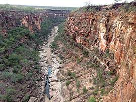 Porcupine Creek flowing through Porcupine Gorge, 2015 | |||||||||||||||
 Porcupine | |||||||||||||||
| Coordinates | 20.1187°S 144.2989°E | ||||||||||||||
| Population | 49 (2016 census)[1] | ||||||||||||||
| • Density | 0.00550/km2 (0.01425/sq mi) | ||||||||||||||
| Postcode(s) | 4821 | ||||||||||||||
| Area | 8,904.7 km2 (3,438.1 sq mi) | ||||||||||||||
| LGA(s) | Shire of Flinders | ||||||||||||||
| State electorate(s) | Traeger | ||||||||||||||
| Federal Division(s) | Kennedy | ||||||||||||||
| |||||||||||||||
Geography
The drainage divide created by the Great Dividing Range runs from north to south near the eastern boundary of the locality. As a consequence, the terrain in the locality is mountainous with peaks (from north to south) including Mount King 900 metres (3,000 ft), Mount Mistake 910 metres (2,990 ft), Mount Dick 900 metres (3,000 ft), Mount Cracknell 886 metres (2,907 ft), Mount Bradshaw 850 metres (2,790 ft), Mount James 968 metres (3,176 ft), Mount Emu 976 metres (3,202 ft), Mount Pleasant 814 metres (2,671 ft), Mount Oxley 810 metres (2,660 ft), Mount Sturgeon 795 metres (2,608 ft), Bald Hill 689 metres (2,260 ft), Mount Pleasant (again) 762 metres (2,500 ft), Mount Wongalee 515 metres (1,690 ft), and Mount Canterbury 466 metres (1,529 ft).[3]
Numerous creeks rise in this area flowing into valleys west towards inland Queensland where they eventually become tributaries of the Flinders River which flows through the Gulf Country to the Gulf of Carpentaria. In contrast, the South Gregory River rises to the east of the divide and flows eventually into the Burdekin River which enters the Coral Sea at Upstart Bay, east of Ayr.[3]
The Kennedy Developmental Road runs from north to south through the locality.[3]
Some small areas of the locality are part of a number of national parks including Porcupine Gorge National Park (which protects the Porcupine Gorge created by Porcupine Creek, entirely within the southern part of the locality), White Mountains National Park (extending south-east into Torrens Creek) and Blackbraes National Park (extending north into Lyndhurst).[3]
History
.jpg)
The locality was named and bounded on 23 February 2001.[2] The name is believed to derive from the appearance of the spiky leaves of the spinifex bushes in the area. In particular the Triodia scariosa is commonly known in Australia as ' porcupine grass '.[4]
Education
There are no schools in Porcupine, but neighbouring Hughenden has both primary and secondary schools.[3]
References
- Australian Bureau of Statistics (27 June 2017). "Porcupine (SSC)". 2016 Census QuickStats. Retrieved 20 October 2018.

- "Porcupine - locality in Flinders Shire (entry 42486)". Queensland Place Names. Queensland Government. Retrieved 12 December 2018.
- "Queensland Globe". State of Queensland. Retrieved 12 December 2018.
- "Origin of Place Names in Hughenden and District" (PDF). Archived from the original (PDF) on 12 July 2011. Retrieved 12 December 2018.
External links
![]()