Pelsall
Pelsall is a large village [2] situated in the Walsall Borough, West Midlands, England. Pelsall is quite central with the larger towns of Bloxwich and Brownhills being only two miles apart from the centre and it is also on the border of Cannock Chase near Norton Canes. Pelsall is also 7 miles from the nearby city of Lichfield and a similar distance to Wolverhampton. Walsall is around 3 miles away.
| Pelsall | |
|---|---|
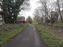
 Pelsall Village | |
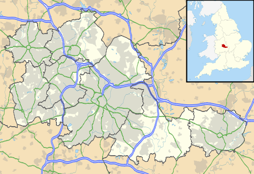 Pelsall Location within the West Midlands | |
| Population | 11,505 (2011 Ward)[1] |
| OS grid reference | SK020037 |
| Metropolitan borough | |
| Metropolitan county | |
| Region | |
| Country | England |
| Sovereign state | United Kingdom |
| Post town | WALSALL |
| Postcode district | WS3 |
| Dialling code | 01922 |
| Police | West Midlands |
| Fire | West Midlands |
| Ambulance | West Midlands |
| UK Parliament | |
History
Pelsall was first mentioned in a charter of 994, when it was among various lands given to the monastery at Heantune (Wolverhampton) by Wulfrun, a Mercian noblewoman. At this time it was called Peolshalh, meaning 'a nook' or 'land between two streams belonging to Peol'. The Domesday entry of 1086 describes Pelsall as being waste, still belonging to the church.
A chapel of ease was built in about 1311. The medieval population was small and a return of 1563 lists only 14 householders. The original centre the area is now known as Old Town. In 1760 the remaining open fields were enclosed, but some holdings survived into the next century in Hall Field, High Ley, The Riddings Field and Final Field. The tithe map of about 1840 records some evidence of the medieval strip farming system.
In the second quarter of the 19th century, clusters of houses were built on the fringes of the extensive common land and at the Newlands. The greatest concentration was in what is now the village centre. This area gradually developed; a Methodist Chapel and school were opened in about 1836, in the modern day Station Road and a new St Michael's Church was built in 1844 – the old one in Paradise Lane had been considered too small for the growing population. Towards the end of the 19th century, shops became established in Norton Road and High Street. The population in 1801 was 477 and by 1901 had grown to 3,626.
Pelsall had become a mining village; in places deposits of coal were found only a few yards from the surface and by about 1800 the shallow and deep seams were 'much worked'. The cutting of the canal in about 1794 opened up the area for industrialisation, with entrepreneurs and landowners quickly exploiting the mineral wealth. Nailmaking, traditionally a cottage industry, was also carried out locally; in the census of 1841 thirty men stated this as their occupation.
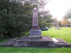
On 14 November 1872, 22 miners died when the Pelsall Hall Colliery was flooded.[3][4] 21 of the 22 miners were buried underneath a polished granite obelisk in the churchyard of St Michael and All Angels Church.[5]
An ironworks[6] was established on the North Common which grew into a sizeable concern under the ownership of Messrs. Davis and Bloomer. This, together with Yorks Foundry and that of Ernest Wilkes and Co. at Mouse Hill, gave Pelsall a share of the heavy iron trade during the 19th century. Ernest Wilkes and Co. survived until 1977, but the others ceased trading in the 1890s and the pits became unworkable, mainly due to continual flooding problems.
Several working farms survived in the local area until after the Second World War. Since then much land has been used for housing development but the ancient common remains.
Governance
Pelsall is part of the Aldridge-Brownhills Parliamentary constituency. At the 2010 general election, the seat was held by Richard Shepherd (Conservative) with a majority of 15,266 over Labour's Ashiq Hussain. The seat has been held by the Conservative Party since 3 May 1979.[7]
Pelsall Ward has 3 council seats. The 3 current councillors, all Conservative, are Garry Perry former Mayor of Walsall re-elected in 2012; Marco Longhi elected in 2011; and Oliver Bennett elected in 2010.
Suburbs

Districts of pPlsall include: Pelsall Wood, Ryders Hayes, High Heath and Heath End.
Ethnicity and religion

Pelsall has three churches in its village. Pelsall is predominately White British but has a large Asian group at 1.2% of the local population with the other 2.8% being made up of minority ethnics. Making the whole ward of Pelsall, 96% White and 4% non-white minorities.[8] Christianity is the largest religion in the borough at 75% of the population followed by no religion at 18%.
Places of worship
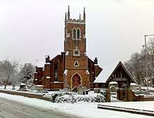


The parish church of Pelsall is St Michael and All Angels Church. Other places of worship are Pelsall Evangelical Church and Pelsall Methodist Church.
Landmarks
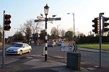
The Fingerpost, at the junction of B4154 Norton Road and A4124 Lichfield Road is an unusual and possibly unique design and was substantially restored in the 1980s by Bert Kellitt for the local Civic Society. Pelsall Social Club is at the junction of these roads. Its local nickname, The Scratter, is derived from the name of the original establishment The Scratching Pen.
Since the late 1990s, Pelsall has had a Millennium Stone, marking the 994–1994 millennium of the village.
Pelsall is quite 'green' with a large turf central common around which previously had several public houses : Only The Railway and The Queens (formerly The Block & Chopper) survive today, with The Old House at Home further up, towards the Fingerpost. Previous Public houses surrounding the Common included, The Bush (currently under consideration as a site for an aldi supermarket) , and The Red Cow, both of which are now closed. In July each year, the Common is the site on which Pelsall Carnival is centred. The carnival features decorated floats and bric-a-brac stalls. It has run continuously since 1972 with the exception of 2020.[9]
The main shopping area serving the town is bordered by Norton Road and High Street and includes a range of shops, including a butcher, plus a variety of food outlets for eat in or take away. On the northern edge of the village centre there is The Old House at Home public house, while The Fingerpost pub (formerly The Royal Oak) is situated just north of the Fingerpost road junction at Yorks Bridge, near to Pelsall Junction on the Wyrley and Essington Canal, and Nest Common and North Common, on the border with South Staffordshire.
In 1997 the Donna Cooper Memorial Garden was created in the village in memory of thirteen-year-old Donna Cooper, who died after being knocked over by a stolen car outside her home in Pelsall Lane, Rushall on 6 January 1993. The driver and his accomplice were both on bail at the time, after being arrested in connection with a hit-and-run incident in which two men had been injured weeks before Cooper's death.[10] The garden was commissioned by Walsall Metropolitan Borough Council, who also maintain it. It was designed by Anuradha Patel. The entrance consists of an arched gateway that contains an owl motif, taken from a design drawn by Cooper shortly before her death. The garden is 200 metres (656 ft) long and 25 metres (82 ft) wide.[5]
Pelsall has lost several pubs in recent years, including The Free Trade in Wood Lane, which, though the building remains, has been closed for several years, and The Swan on Wolverhampton Road, which in 2007 was converted to an Indian restaurant. The red cow public house and its car park have been converted into flats, the old bush stands derelict after several arson attacks and is now subject to a proposal by aldi to build a supermarket and care home on the site.
Transport

Pelsall once had a comprehensive bus network which included bus 89, which connected it to Wolverhampton, Bloxwich, Wednesfield and New Cross Hospital. This allowed passengers to interchange at both Bloxwich station on the Chase Line and at Wolverhampton station for further travel to Shropshire, Staffordshire and Manchester. The bus was axed in 28 April 2019 bus timetable change by National Express West Midlands. It was cut back to Bloxwich instead of Walsall and to Wolverhampton. This means passengers have to change at Bloxwich for further travel although bus service is half hourly.
There is a rapid connection to the nearby towns of Brownhills, Cannock and Walsall but the nearest rail connection as Brownhills also lost its station in 1965 are Walsall, Landywood, Cannock, Penkridge and Shenstone as well as Lichfield. There is also a six journey off peak service to Kingstanding via Aldridge and Pheasy. Also a direct Brownhills to Bloxwich service but this only runs from 8am-4pm on Monday till Saturday.
Pelsall previously had a railway station on the South Staffordshire Line that ran east of the village, this closed in 1960s to passengers and to freight in 1980s. Only the main road bridges survive as evidence. The line and station have been mooted for reopening since the early 2000s but due to low demand. These have kept the line and station from being reopened although a study carried out in 2009 by the Department for Transport have suggested a new station at Pelsall and Brownhills. In 2000 the track bed from Walsall to Pelsall was made into part of the SUSTRANS National Cycle Route 5. The line through Pelsall has been identified as a disused rail corridor and this means that it is a long term ambition to reopen the line in the near future. Either for trains or tram trains.[11]
Education
Pelsall is currently home to three primary schools: St Michael's C of E Primary,[12] Pelsall Village School[13] and Ryders Hayes School[14][15] (now an Academy), and First Friends Day Nursery located at Pelsall Education Development Centre.[16]
Pelsall was previously served by Pelsall Comprehensive School, although technically over the border in neighbouring Rushall. It opened in the autumn of 1963 as an 11–15 secondary modern school before adopting 13–18 comprehensive status in September 1972. The transfer age was reduced to 11 in September 1986 under Walsall's reorganisation of education in the former Aldridge-Brownhills area but falling pupil numbers led to its closure in July 1994.[17]
The old Pelsall Comprehensive buildings are now home to Rushall JMI School, Education Walsall offices and a teacher training centre.
Sport
Pelsall's main football team was Pelsall Villa who played in the Midland Football League until 2018 when they were disbanded. They formed in 1961. Pelsall Villa's ground in Walsall Road neighbours Pelsall Cricket Club and the Old Bush pub. (both currently subject to a proposal to build a small aldi and care home on the now derelict site and provide needed care for the elderly and employment via aldi)
References
- "Pelsall Ward (as of 2011)". Neighbourhood Statistics. Office for National Statistics. Retrieved 19 December 2015.
- https://go.walsall.gov.uk/pelsall_in_history. Missing or empty
|title=(help) - "Pelsall Hall 1872". www.ccmhs.co.uk. Retrieved 7 June 2017.
- "pelsall-history.co.uk". www.pelsall-history.co.uk. Retrieved 7 June 2017.
- George Thomas Noszlopy; Fiona Waterhouse (2005). Public Sculpture of Staffordshire and the Black Country. Liverpool University Press. ISBN 0-85323-999-1.
- "pelsall-history.co.uk". www.pelsall-history.co.uk. Retrieved 7 June 2017.
- "Politics". The Guardian. London. Archived from the original on 20 August 2008.
- (PDF) https://www.walsallintelligence.org.uk/wp-content/uploads/sites/6/2019/02/09-Ward-Walks-2018-PELSALL.pdf. Retrieved 17 August 2019. Missing or empty
|title=(help) - "pelsall-history.co.uk". www.pelsall-history.co.uk. Retrieved 7 June 2017.
- "Seven-year sentence for joyrider who killed girl: Judge attacks 'folly' of giving repeated bail to youths who ignore conditions". The Independent. London. 8 October 1993.
- https://www.tfwm.org.uk/media/2525/annex-1-corridors.pdf
- "Inspection report". www.ofsted.gov.uk. 5 November 2010. Retrieved 7 June 2017.
- "Inspection report". www.ofsted.gov.uk. 5 November 2010. Retrieved 7 June 2017.
- http://www.ofsted.gov.uk/inspection-reports/find-inspection-report/provider/ELS/104205
- "Inspection report". www.ofsted.gov.uk. 5 November 2010. Retrieved 7 June 2017.
- "Inspection report". www.ofsted.gov.uk. 5 November 2010. Retrieved 7 June 2017.
- "Pelsall Community School, Rushall, Walsall: Schools in Walsall". schooletc.co.uk. Retrieved 7 June 2017.
External links
| Wikimedia Commons has media related to Pelsall. |
- Common People – local news blog
- Pelsall Pride Partnership
- Pelsall Online
- Pelsall Community Association
- Pelsall History Centre's site
- Information relating to the Pelsall Hall Colliery disaster of 1872
- The story of the 32nd (Aldridge) Battalion, South Staffordshire Home Guard, 1940–1944
| Authority control |
|
|---|