Païta
Païta (French pronunciation: [pajta]) is a commune in the suburbs of Nouméa in the South Province of New Caledonia, an overseas territory of France in the Pacific Ocean. New Caledonia's international airport, La Tontouta International Airport, is located there.
Païta | |
|---|---|
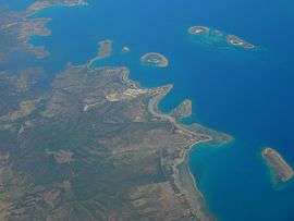 An aerial view of Païta | |
 Location of the commune (in red) within New Caledonia | |
Location of Païta 
| |
| Coordinates: 22°08′01″S 166°21′02″E | |
| Country | France |
| Sui generis collectivity | New Caledonia |
| Province | South Province |
| Government | |
| • Mayor | Harold Martin |
| Area 1 | 699.7 km2 (270.2 sq mi) |
| Population (2019 census) | 24,563 |
| • Density | 35/km2 (91/sq mi) |
| Ethnic distribution | |
| • 2014 census | Europeans 23.84% Wallisians and Futunans 20.46% Kanaks 20.1% Mixed 13.2% Other 22.4% |
| Time zone | UTC+11:00 |
| INSEE/Postal code | 98821 /98890 |
| Elevation | 0–1,618 m (0–5,308 ft) (avg. 30 m or 98 ft) |
| 1 New Caledonia Land Register (DITTT) data, which exclude lakes and ponds larger than 1 km² (0.386 sq mi or 247 acres) as well as the estuaries of rivers. | |
Sights


The Catholic church in the centre of Paita was built in 1875. The modern Cultural Centre in the High Street is used for various exhibitions and cultural performances. The Town Hall (Mairie) is close by.
About one mile from the town centre to the north, is the former railway station of the Nouméa-Païta railway where a small locomotive which was used until 1940 can be seen.[1]
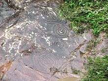
In the southeast of Paita petroglyphs possibly dating from the 13th or 14th century B.C. can be seen on a rock at a small river. Some of the petroglyphs look similar to the sun or to flowers. From the road the place can be reached by cement stairs behind a wooden pavilion.[2]
References
- Piere Grundmann: Nouvelle Calédonie, p. 110. Paris 2012
- Pierre Grundmann: Nouvelle Calédonie, p. 242. Paris 2012
External links
| Wikimedia Commons has media related to Païta. |
| Provinces | |
|---|---|
| Communes | |
| Authority control |
|
|---|