Otematata
Otematata is a town in the Waitaki District of Canterbury in New Zealand's South Island. It is defined as a "populated area less than a town"[2] and the 2001 New Zealand census gave the "usually resident population count" as 243.[3] By the 2006 census it had declined to 189 inhabitants. This was considerably higher in the 1960s during the construction of the Benmore and Aviemore dams.
Otematata | |
|---|---|
Town | |
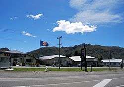 New Zealand State Highway 83 passing through Otematata | |
 Otematata | |
| Coordinates: 44°36′25″S 170°11′28″E | |
| Country | New Zealand |
| Region | Canterbury |
| Territorial authority | Waitaki District |
| Population (2006)[1] | |
| • Total | 189 |
| Time zone | UTC+12 (New Zealand Standard Time) |
| • Summer (DST) | UTC+13 (New Zealand Daylight Time) |
| Postcode | 9412 |
| Local iwi | Ngāi Tahu |
Surrounded by rugged peaks and beautiful lakes of the Waitaki Valley, the earliest inhabitants of the area were Māori on hunting expeditions or travelling through the valley to reach the inland areas and mountain passes. Otematata in Māori means "place of good flint".[4]
The Otematata township was built in 1958 as a base for the construction of the Aviemore and Benmore Dams. ECNZ (Electricity Corporation of New Zealand) used it as a base until the early 1990s. Prior to that there were a few 'high country' sheep stations, Rostiever Run owned by the Munro family and Otematata Station owned by the Cameron family.
ECNZ's successors' presence is now minimal as the dams are operated by remote control, and Otematata is becoming a village of holiday homes. It is a popular holiday destination with a hotel, restaurant, camping ground, backpackers, and other basic services. The townships population swells to over 5000 people in the Christmas and New Year holiday season as holiday makers from around New Zealand come to enjoy the lakes. Water skiing is a popular pastime in the Waitaki Valley.
Like many inland areas, Otematata has weather that ranges from very cold in winter to very hot in summer. In the past five years, temperatures have ranged from 35.7 °C to −6.7 °C, with annual rainfall ranging from 282mm to 431mm.[5]
 The Otematata Holiday Park and Lodge.
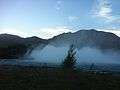 The Benmore Dam spillway in full force.
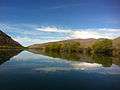 A spring day on Lake Aviemore.
References
- "QuickStats About Otematata". 2006 Census. Statistics New Zealand. Retrieved 6 December 2011.
- "Place name detail: Otematata". New Zealand Gazetteer. Land Information New Zealand. Retrieved 29 May 2007.
- Statistics New Zealand, Otematata Community Profile, accessed 29 May 2007.
- "Maori Place Names – What do they mean?". Art and Tels diary of New Zealand.
- "Otematata's weather monitoring station".
| Wikimedia Commons has media related to Otematata. |