Ohio State Route 94
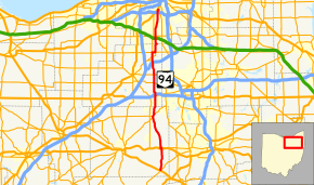
State Route 94 (SR 94) is a north–south state highway in the U.S. state of Ohio. It stretches 54 miles (87 km) from U.S. Route 250 and SR 241 in the village of Mount Eaton to U.S. Route 42 in Cleveland.
| ||||
|---|---|---|---|---|
 | ||||
| Route information | ||||
| Maintained by ODOT | ||||
| Length | 54.50 mi[1] (87.71 km) | |||
| Existed | 1924–present | |||
| Major junctions | ||||
| South end | ||||
| ||||
| North end | ||||
| Location | ||||
| Counties | Wayne, Medina, Cuyahoga | |||
| Highway system | ||||
| ||||

History
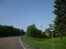
SR 94 south of Wadsworth
- 1924: State Route 94 was formed. It originally ran from Riceland, a village south of Orrville, to what was then State Route 36[2] (now State Route 585) north of Orrville.
- 1926: Extended north to Cleveland and its current northern terminus along a formerly unnumbered road.
- 1935: Extended again, this time southward to U.S. Route 250.
- 1938: Extended past U.S. Route 250 to the town of Fredericksburg.
- 1963: The route is truncated from Fredericksburg to U.S. Route 30 at Riceland. The former route is now Wayne County Route 94A (Carr Road).
- 1969: State Route 57 is extended along the existing route of State Route 94 from Riceland to State Route 585[2] (formerly State Route 5). State Route 94 is rerouted from Wadsworth to its current southern terminus at Mount Eaton.[3]
Major junctions
| County | Location | mi[1] | km | Destinations | Notes |
|---|---|---|---|---|---|
| Wayne | Mount Eaton | 0.00 | 0.00 | ||
| Dalton | 7.13 | 11.47 | |||
| 7.39 | 11.89 | Southern end of US 30 Alt. concurrency | |||
| 7.59 | 12.21 | Northern end of US 30 Alt. concurrency | |||
| Chippewa Township | 18.21 | 29.31 | Southern end of SR 585 concurrency; eastern terminus of SR 604 | ||
| 19.07 | 30.69 | Northern end of SR 585 concurrency | |||
| Medina | Wadsworth | 24.78 | 39.88 | Western terminus of SR 261 | |
| 25.48– 25.56 | 41.01– 41.13 | Exit 9 (I-76) | |||
| Sharon Township | 29.42– 29.46 | 47.35– 47.41 | Traffic circle | ||
| Sharon–Granger township line | 32.03 | 51.55 | |||
| Granger Township | 35.95– 36.09 | 57.86– 58.08 | Exit 3 (I-271) | ||
| Granger–Hinckley township line | 36.70 | 59.06 | Southern end of SR 3 concurrency | ||
| Hinckley Township | 37.73 | 60.72 | |||
| 39.23 | 63.13 | Northern end of SR 3 concurrency, Southern end of SR 303 concurrency | |||
| 40.10 | 64.53 | Northern terminus of SR 606 | |||
| 40.22 | 64.73 | Northern end of SR 303 concurrency | |||
| Cuyahoga | North Royalton | 45.73 | 73.60 | ||
| Parma–Cleveland city line | 53.09 | 85.44 | |||
| Cleveland | 53.24– 53.31 | 85.68– 85.79 | Exit 16 (I-480) | ||
| 54.50 | 87.71 | ||||
1.000 mi = 1.609 km; 1.000 km = 0.621 mi
| |||||
References
- "DESTAPE". Ohio Department of Transportation. July 16, 2013. Retrieved September 12, 2014.
- Simpson, John. "Route 585". The Unofficial Ohio State Highways Web Site. Archived from the original on March 9, 2008. Retrieved 2008-03-30.
- Simpson, John. "Route 94". The Unofficial Ohio State Highways Web Site. Archived from the original on March 7, 2008. Retrieved 2008-03-30.
This article is issued from Wikipedia. The text is licensed under Creative Commons - Attribution - Sharealike. Additional terms may apply for the media files.