Oak Park, Sacramento, California
Oak Park is a neighborhood in Sacramento, California. The McGeorge School of Law, University of the Pacific Sacramento Campus, Sacramento High School, and Christian Brothers High School are located in this neighborhood.
Oak Park | |
|---|---|
Neighborhood of Sacramento | |
 Broadway Triangle District in Oak Park | |
 Oak Park Location within Sacramento | |
| Coordinates: 38.544045°N 121.463116°W | |
| Country | United States |
| State | California |
| County | Sacramento |
| City | Sacramento |
| Zip Codes | 95817 and 95820 |
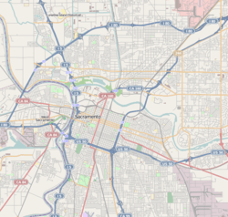
Oak Park is informally bounded by U.S. Route 50 to the north, Stockton Boulevard to the east, the South Sacramento (99) Freeway to the west and Fruitridge Road to the south.[1] It is situated within the city limits and provides easy access to Downtown Sacramento. Numbered streets intersect with numbered avenues, with Broadway and Martin Luther King Jr. Boulevard (formerly known as Sacramento Boulevard) comprising the main thoroughfares.
History
The early 1900s saw Oak Park as a culturally thriving and economically vibrant, destination neighborhood,[2][3] due in part to its strong sense of community and its ties with and proximity to the Historic site of the California State Fair grounds. The 1960s Interstate freeway expansion program physically divided many historic Sacramento neighborhoods like Oak Park creating isolated areas of poverty or relative prosperity. Oak Park's sense of community started to decline in the early 1960s as a result of the freeway expansion, declining property values and families moving out to the suburb communities now made easily accessible by the freeway expansion programs. During the 1980s / 90's further deterioration of the living standards were exacerbated by frequent occurrences of petty theft, street crime, drug activities, and gang-related violence. Recently, the early 2000s saw a slew of real estate speculators and building contractors buying up low-priced homes in some parts of Oak Park that were either abandoned or sold off as unmanageable, and turning them around and reselling them as reasonably priced starter homes, often with financial government assistance. At the same time many new high-paying jobs moved into the area in connection with the expansion of the University of California Davis Medical Center located to the north of Oak Park, the revitalization of Broadway and Stockton Boulevard, and the expansion of the McGeorge Law School campus.
Oak Park's downtown
In addition to being Sacramento's first suburb, Oak Park also developed a second "downtown" retail and entertainment district, distinct from Sacramento's downtown, running along 35th Street between Sacramento Blvd (Martin Luther King) to the north and 5th Ave and the park to the South. The street was home to the Piggly-Wiggly, Park Meat Market, and Arata Bros markets; Steen's Corner Saloon; Azevedo's Women's Apparel; Janek and Scurfield canvass goods, Citizens Bank of Oak Park; the Ben Franklin variety store; and many others. The street's arts and entertainment could be found at the Victor Theater (Guild Theater), the California Theater, the Belmonte Gallery or the outdoor theater and pavilion at the park. 35th Street area also played host to the annual July 4th parade.[3]
Oak park's streetcars
Four of Sacramento's seven downtown streetcar lines terminated in Oak Park. The original line, the Central Street Railway, was founded in 1890 by real estate investor Edwin K. Alsip in hopes of motivating people to move to Oak Park and Highland Park. The horse-drawn streetcars were replaced by cable cars, and shortly after, electric trolley cars. Originating at Second and H streets, it followed J Street to 28th St, then south to Sacramento Boulevard (now called Broadway), where it turned east into the new suburbs of Oak Park. The eastern terminus was a public park, then known as Oak Park (now McClatchy Park), on 35th Street and Fifth Avenue. Sacramento Electric, Gas & Railway Company (later Pacific Gas and Electric Company) would acquire this route and expand to include Route 6 which ran to the Oak Park terminus via Fifth Avenue. Meanwhile, a short Route 5 would run east from the Oak Park terminus and end at the Historic site of the California State Fair grounds on Stockton Boulevard.[4][5]
The Central California Traction Company also ran an interurban rail line from Downtown Sacramento to Stockton. The line headed through Oak Park along Sacramento Boulevard, then Second Avenue, and finally turned south at Stockton Boulevard, running down the eastern edge of Oak Park towards Stockton.
Joyland
In 1895, Oak Park (McClatchy Park) featured acres of shady oak trees, a zoo, carousel, and ballpark. When Sacramento Electric, Gas & Railway Company acquired the Oak Park terminus in 1903, they added a wooden roller coaster, a roller skating rink, an outdoor theater, and a scenic miniature railway. Joyland was born when the park was renovated to include an amusement park, electric lights, and swimming pool. In addition to local amusement, Joyland was intended to showcase the abilities of electric power and increase ridership on the new electric streetcars.[3]
Joyland caught fire in 1920 and never reopened. In 1927, Valentine McClatchy purchased the land and gave it to the city to become a city park, named in honor of his father James McClatchy, the founder of the Sacramento Bee.[6]
Recent past
As of 2008, Oak Park faced a variety of challenges sustaining the beginnings of its comeback due in part to an increase in foreclosures and an area-wide decline in property values. Community groups like the Oak Park Neighborhood Association, the South Oak Park Community Association (SOPCA) established in 2014, Community policing efforts, the demand for affordable housing close to the University of California Davis Medical Center and the overall impact that the real estate market will play in the future.
Notable residents
- Lotar A. Lampe Sr. Served the community 1993–2011. Extremely involved in community service projects and programs. Oak Park resident from 1974 to 2011. Worked with the Sacramento P.D. in community service, volunteered with Probation to supervise probationers that were doing community service hours, and volunteered whenever possible in events that beautified improved and led to change in Oak Park. He was the president of the Oak Ridge/Christian Brothers Drug Free Zone, and the president of the 35th Street Neighborhood Association. He also volunteered many hours at both the Oak Park Community Center and Father Keith B. Kenny Elementary School, while also raising his two teenage granddaughters.
- Kevin Johnson, former Mayor of Sacramento, and former NBA star
- Deborah Ortiz, former California State Legislator representing districts that included Oak Park.
- Diego Corrales, former boxing champion (deceased)
- Cynthia Robinson, Rock and Roll Hall of Fame inductee, trumpeter and vocalist in Sly and the Family Stone.
- Chino Moreno, vocalist of alternative rock group Deftones.
- Mozzy, Rapper.
- Callie Carney, Co-founder, CEO, President, Director of Women's Civic Improvement Center, Greater Sacramento Urban League, City Council Member.
References
- "Oak Park Neighborhood Association (OPNA)". cityofsacramento.org. City of Sacramento. Retrieved June 14, 2014.
- OldManFoster. "A Brief History of Oak Park". Midtown Monthly. Retrieved June 4, 2012.
- "City of Sacramento – Center for Sacramento History – Walking Tours" (PDF). City of Sacramento. Retrieved June 4, 2012.
- Rodda, Richard. "Sacramento's Streetcars" (PDF). schs.sacramentohistory.info. Sacramento City Historical Society. Archived from the original (PDF) on February 23, 2015. Retrieved June 14, 2014.
- Burg, William (August 29, 2007). "Sacramento's Streetcar Suburbs, Part 2". sacramentohistory.blogspot.com. The Sacramento Old City Association. Retrieved June 14, 2014.
- "McClatchy Park and Joyland". cdm15248.contentdm.oclc.org. The Sacramento Room Digitization Project. Retrieved June 14, 2014.