Nordre Land
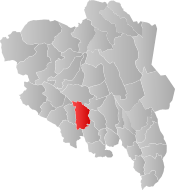
Nordre Land is a municipality in Innlandet (formerly Oppland) [3] county, Norway. It is part of the traditional region of Land. The administrative centre of the municipality is the village of Dokka.
Nordre Land kommune | |
|---|---|
 Dokka in Nordre Land | |
 Coat of arms 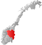 Innlandet within Norway | |
 Nordre Land within Innlandet | |
| Coordinates: 60°55′55″N 10°1′2″E | |
| Country | Norway |
| County | Innlandet |
| District | Land, Norway |
| Administrative centre | Dokka |
| Government | |
| • Mayor (2015) | Ola Tore Dokken (SP) |
| Area | |
| • Total | 955 km2 (369 sq mi) |
| • Land | 921 km2 (356 sq mi) |
| Area rank | 112 in Norway |
| Population (2004) | |
| • Total | 6,916 |
| • Rank | 143 in Norway |
| • Density | 8/km2 (20/sq mi) |
| • Change (10 years) | -0.7% |
| Demonym(s) | Nordrelending[1] |
| Time zone | UTC+01:00 (CET) |
| • Summer (DST) | UTC+02:00 (CEST) |
| ISO 3166 code | NO-3448 |
| Official language form | Bokmål[2] |
| Website | www |
The old municipality of Land was divided into Nordre Land and Søndre Land in 1847. The area of Torpa was separated from Nordre Land on 1 January 1914 to become a separate municipality, but it was merged back into Nordre Land on 1 January 1962.
General information
Name
The Old Norse form of the name was just Land which means "land". The meaning of the name Nordre Land is "(the) northern (part of) Land". The parish and municipality of Land was divided in 1847.[4]
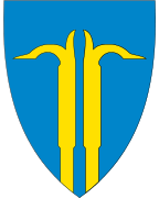
Coat-of-arms
The coat-of-arms is from modern times. They were granted in 1987. The arms show two gold-colored hooks for log driving (or "brøtningshaker") on a blue background. They were designed by Dag Magne Staurheim. The municipality of Nordre Land has rich traditions within the field of log driving, to which the vast number of log dams within the area bear witness. Tools were required for the log driving, and the local blacksmiths made pike poles. Every blacksmith created his own shape or design for the poles, and one of the most famous pike poles in Nordre Land was the design made by the blacksmith Kristian Halden. In addition to pike poles he made knives. The poles and knives were named "Hæillhakar" and "Hæillakniver" by the locals. It is the "Halden Pole" which has been the model for the municipal arms of Nordre Land.[5]
| Ancestry | Number |
|---|---|
| 116 | |
| 53 | |
| 41 | |
| 36 | |
| 29 | |
| 25 | |
| 22 |
Geography
Nordre Land is bordered on the north by the municipalities of Nord-Aurdal and Gausdal, on the northeast by Lillehammer, on the east by Gjøvik, on the south by Søndre Land, on the southwest by Sør-Aurdal, and on the west by Etnedal.
The river Etna flows from Etnedal and through western parts of the municipality down into the Randsfjorden. Lake Akksjøen is also in this area.
Attractions
- The rock carvings at Møllerstufossen are more than 6,000 years old. There are 11 carvings of moose, and also two that are more difficult to interpret. Sometime in the Stone Age this must have been an important place.
- The Lands Museum is located in Dokka. About thirty buildings are reassembled in the area. In the main building from the Thomle farm there are rococo paintings on the walls by Peder Aadnes dating from about 1750.
 Rock carvings at Møllerstufossen
 Main house Halmrast, Lands Museum
 Østsinni church in Dokka
Notable residents
- Anna Georgine Rogstad (1845–1938), was the first woman elected to the Storting.
References
- "Navn på steder og personer: Innbyggjarnamn" (in Norwegian). Språkrådet.
- "Forskrift om målvedtak i kommunar og fylkeskommunar" (in Norwegian). Lovdata.no.
- moderniseringsdepartementet, Kommunal- og (7 July 2017). "Regionreform". Regjeringen.no. Archived from the original on 23 March 2018. Retrieved 28 April 2018.
- Rygh, Oluf (1900). Norske gaardnavne: Kristians amt (Anden halvdel) (in Norwegian) (4 ed.). Kristiania, Norge: W. C. Fabritius & sønners bogtrikkeri. pp. 179 & 196.
- "Kommunevåpen for Nordre Land". Nordre Land kommune. Archived from the original on 2011-07-24. Retrieved 2009-01-04.
- "Immigrants and Norwegian-born to immigrant parents, by immigration category, country background and percentages of the population". ssb.no. Archived from the original on 2 July 2015. Retrieved 29 June 2015.
External links
| Wikimedia Commons has media related to Nordre Land. |
| Look up Nordre Land in Wiktionary, the free dictionary. |
- Municipal fact sheet from Statistics Norway

 |  | ||||||||||||||||||||||||||||||||||||
|