National Register of Historic Places listings in Pasco County, Florida
This is a list of the National Register of Historic Places listings in Pasco County, Florida.
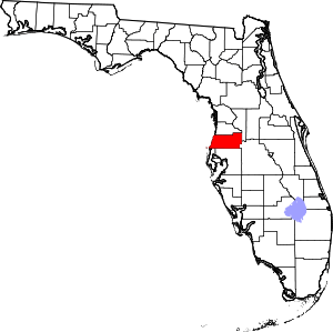
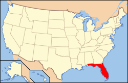
Location of Pasco County in Florida
This is intended to be a complete list of the properties and districts on the National Register of Historic Places in Pasco County, Florida, United States. The locations of National Register properties and districts for which the latitude and longitude coordinates are included below, may be seen in a map.[1]
There are 10 properties and districts listed on the National Register in the county.
- This National Park Service list is complete through NPS recent listings posted August 14, 2020.[2]
| Alachua - Baker - Bay - Bradford - Brevard - Broward - Calhoun - Charlotte - Citrus - Clay - Collier - Columbia - DeSoto - Dixie - Duval - Escambia - Flagler - Franklin - Gadsden - Gilchrist - Glades - Gulf - Hamilton - Hardee - Hendry - Hernando - Highlands - Hillsborough (Tampa) - Holmes - Indian River - Jackson - Jefferson - Lafayette - Lake - Lee - Leon - Levy - Liberty - Madison - Manatee - Marion - Martin - Miami-Dade (Miami) - Monroe - Nassau - Okaloosa - Okeechobee - Orange - Osceola - Palm Beach - Pasco - Pinellas - Polk - Putnam - St. Johns - St. Lucie - Santa Rosa - Sarasota - Seminole - Sumter - Suwannee - Taylor - Union - Volusia - Wakulla - Walton - Washington |
Current listings
| [3] | Name on the Register[4] | Image | Date listed[5] | Location | City or town | Description |
|---|---|---|---|---|---|---|
| 1 | Charles B. Anderson House |  Charles B. Anderson House |
April 26, 1996 (#96000467) |
5744 Moog Road 28°12′31″N 82°43′09″W |
Holiday | NRHP# 96000467 |
| 2 | Samuel Baker House |  Samuel Baker House |
February 14, 1997 (#97000052) |
5744 Moog Road 28°12′31″N 82°43′11″W |
Elfers | NRHP# 97000052 |
| 3 | Church Street Historic District |  Church Street Historic District |
August 21, 1997 (#97000910) |
Along Church Street between 9th and 17th Streets 28°21′47″N 82°11′42″W |
Dade City | NRHP# 97000910 |
| 4 | Dade City Atlantic Coast Line Railroad Depot | 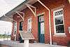 Dade City Atlantic Coast Line Railroad Depot |
July 15, 1994 (#94000706) |
Eastern side of Lakeland Road at its junction with East Meridian Avenue 28°21′51″N 82°11′04″W |
Dade City | NRHP# 94000706 |
| 5 | Dade City Woman's Club | 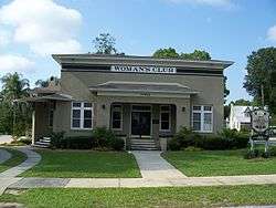 Dade City Woman's Club |
October 13, 2003 (#03001014) |
37922 Palm Avenue 28°21′29″N 82°11′23″W |
Dade City | NRHP# 03001014, Part of the Clubhouses of Florida's Woman's Clubs MPS |
| 6 | Hacienda Hotel | 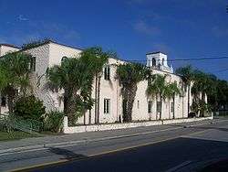 Hacienda Hotel |
October 24, 1996 (#96001185) |
5621 Main Street 28°15′01″N 82°42′48″W |
New Port Richey | NRHP# 96001185 |
| 7 | Capt. Harold B. Jeffries House |  Capt. Harold B. Jeffries House |
November 29, 1995 (#95001370) |
38537 5th Avenue 28°14′04″N 82°10′47″W |
Zephyrhills | NRHP# 95001370 |
| 8 | Pasco County Courthouse |  Pasco County Courthouse |
September 20, 2006 (#06000843) |
37918 Meridian Avenue 28°21′50″N 82°11′20″W |
Dade City | NRHP# 06000843 |
| 9 | St. Leo Abbey Historic District |  St. Leo Abbey Historic District |
January 7, 1998 (#97001637) |
33701 State Road 52 28°20′14″N 82°15′36″W |
St. Leo | NRHP# 97001637 |
| 10 | Zephyrhills Downtown Historic District | 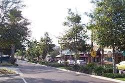 Zephyrhills Downtown Historic District |
September 27, 2001 (#01001058) |
Roughly bounded by South Avenue, 9th Avenue, 7th Street, and 11th Street 28°14′04″N 82°10′46″W |
Zephyrhills | NRHP# 01001058 |
See also
| Wikimedia Commons has media related to National Register of Historic Places in Pasco County, Florida. |
References
- The latitude and longitude information provided in this table was derived originally from the National Register Information System, which has been found to be fairly accurate for about 99% of listings. Some locations in this table may have been corrected to current GPS standards.
- "National Register of Historic Places: Weekly List Actions". National Park Service, United States Department of the Interior. Retrieved on August 14, 2020.
- Numbers represent an ordering by significant words. Various colorings, defined here, differentiate National Historic Landmarks and historic districts from other NRHP buildings, structures, sites or objects.
- "National Register Information System". National Register of Historic Places. National Park Service. March 13, 2009.
- The eight-digit number below each date is the number assigned to each location in the National Register Information System database, which can be viewed by clicking the number.
Municipalities and communities of Pasco County, Florida, United States | ||
|---|---|---|
| Cities | | |
| Town | ||
| CDPs |
| |
| Unincorporated communities | ||
| Ghost towns | ||
| Footnotes | ‡This populated place also has portions in an adjacent county or counties | |
This article is issued from Wikipedia. The text is licensed under Creative Commons - Attribution - Sharealike. Additional terms may apply for the media files.