National Register of Historic Places listings in Marshall County, Mississippi
This is a list of the National Register of Historic Places listings in Marshall County, Mississippi.
Location of Marshall County in Mississippi
This is intended to be a complete list of the properties and districts on the National Register of Historic Places in Marshall County, Mississippi, United States. Latitude and longitude coordinates are provided for many National Register properties and districts; these locations may be seen together in a map.[1]
There are 20 properties and districts listed on the National Register in the county. Another property was once listed but has been removed.
- This National Park Service list is complete through NPS recent listings posted August 14, 2020.[2]
Current listings
| [3] | Name on the Register[4] | Image | Date listed[5] | Location | City or town | Description |
|---|---|---|---|---|---|---|
| 1 | Dr. Isham G. Bailey House | 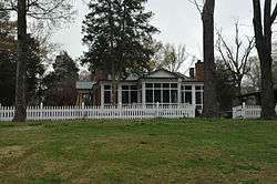 Dr. Isham G. Bailey House |
August 30, 2001 (#01000919) |
1577 Early Grove Rd. 34°59′11″N 89°22′41″W |
Lamar | |
| 2 | Byhalia Historic District |  Byhalia Historic District |
March 7, 1996 (#96000256) |
Roughly along Church, Chulahoma (Mississippi Highway 309) and Senter Sts. 34°52′10″N 89°41′27″W |
Byhalia | Contributing properties include Thistledome. |
| 3 | Byhalia United Methodist Church | April 9, 1984 (#84002276) |
College Ave. 34°52′12″N 89°41′31″W |
Byhalia | ||
| 4 | Chalmers Institute | June 28, 1982 (#82003107) |
W. Chulahoma Ave. 34°46′01″N 89°27′25″W |
Holly Springs | ||
| 5 | Civil War Earthworks at Tallahatchie Crossing | Civil War Earthworks at Tallahatchie Crossing |
August 14, 1973 (#73001021) |
Off Mississippi Highway 7 34°33′25″N 89°29′16″W |
Abbeville | Eight mounds that were parapets used for Union cannons |
| 6 | Confederate Armory Site | April 11, 1972 (#72000699) |
North of Holly Springs 34°46′44″N 89°26′05″W |
Holly Springs | Location in NRIS has the incorrect longitude[6] | |
| 7 | Depot-Compress Historic District |  Depot-Compress Historic District |
April 20, 1983 (#83000959) |
Bounded by the railroad tracks, Chesterman St., and College and Van Dorn Aves. 34°46′05″N 89°26′07″W |
Holly Springs | |
| 8 | East Holly Springs Historic District |  East Holly Springs Historic District |
April 20, 1983 (#83000960) |
Bounded by Compress, Chesterman, Randolph, and Spring Sts. and Salem and Van Dorn Aves. 34°46′11″N 89°26′27″W |
Holly Springs | Includes Cedarhurst a Gothic Revival style residence identified also identified as the Sherwood Bonner house |
| 9 | Hillcrest Cemetery |  Hillcrest Cemetery |
June 28, 1982 (#82003108) |
Center St. 34°45′46″N 89°26′47″W |
Holly Springs | |
| 10 | Holly Springs Courthouse Square Historic District | 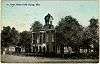 Holly Springs Courthouse Square Historic District |
January 20, 1980 (#80004550) |
U.S. Route 78 34°46′05″N 89°26′52″W |
Holly Springs | |
| 11 | McCoy Administration Building | March 19, 1998 (#98000254) |
150 E. Rust Ave. 34°46′34″N 89°26′49″W |
Holly Springs | ||
| 12 | Mississippi Industrial College Historic District | 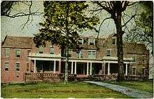 Mississippi Industrial College Historic District |
January 20, 1980 (#80002290) |
Memphis St. 34°46′32″N 89°26′57″W |
Holly Springs | |
| 13 | Myers-Hicks Place |  Myers-Hicks Place |
March 7, 1983 (#83000961) |
Mississippi Highway 309 34°49′47″N 89°41′19″W |
Byhalia | |
| 14 | North Memphis Street Historic District | April 20, 1983 (#83000962) |
Bounded by N. Memphis St., Falconer, Salem, and Park Aves., and the Anderson Chapel 34°46′13″N 89°26′55″W |
Holly Springs | ||
| 15 | Oakview | June 28, 1982 (#82003110) |
Rust Ave. on the Rust College campus 34°46′32″N 89°26′46″W |
Holly Springs | ||
| 16 | Old Water and Electric Light Plant |  Old Water and Electric Light Plant |
June 28, 1982 (#82003111) |
140 E. Falconer Ave. 34°46′09″N 89°26′50″W |
Holly Springs | |
| 17 | Robert Raiford Home and Farm | August 28, 1998 (#98001110) |
829 Cayce Rd. 34°52′10″N 89°37′37″W |
Victoria | ||
| 18 | Southwest Holly Springs Historic District |  Southwest Holly Springs Historic District |
April 20, 1983 (#83000963) |
Bounded by S. Center, S. Memphis, and Craft Sts., Marbury Ct., and Chulahoma, Gholson, Elder and Mason Aves. 34°45′51″N 89°27′04″W |
Holly Springs | |
| 19 | Summer Trees | January 19, 1979 (#79001331) |
Northeast of Red Banks on Mayhome Rd. 34°52′05″N 89°32′54″W |
Red Banks | ||
| 20 | Wall Doxey State Park | 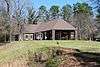 Wall Doxey State Park |
December 1, 1997 (#97001437) |
Between Mississippi Highway 7 and Spring Lake 34°39′51″N 89°27′40″W |
Holly Springs |
Former listing
| [3] | Name on the Register | Image | Date listed | Date removed | Location | City or town | Summary |
|---|---|---|---|---|---|---|---|
| 1 | Malone House | June 28, 1982 (#82003109) | May 25, 1988 | 197 W. College Ave. |
Holly Springs | Demolished in 1988[7] |
See also
| Wikimedia Commons has media related to National Register of Historic Places in Marshall County, Mississippi. |
References
- The latitude and longitude information provided in this table was derived originally from the National Register Information System, which has been found to be fairly accurate for about 99% of listings. Some locations in this table may have been corrected to current GPS standards.
- "National Register of Historic Places: Weekly List Actions". National Park Service, United States Department of the Interior. Retrieved on August 14, 2020.
- Numbers represent an ordering by significant words. Various colorings, defined here, differentiate National Historic Landmarks and historic districts from other NRHP buildings, structures, sites or objects.
- "National Register Information System". National Register of Historic Places. National Park Service. March 13, 2009.
- The eight-digit number below each date is the number assigned to each location in the National Register Information System database, which can be viewed by clicking the number.
- The location drawn on the nomination's topo map matches the township, range, and section in the text, and the hand draw line for latitude is correct, but the longitude is not correct - the hand drawn line for 23 minutes is west of the printed map marker for 25 minutes. The longitude here has been corrected based on the center of the rectangle on the topo map drawing.
- MDAH
| Topics | |
|---|---|
| Lists by state |
|
| Lists by insular areas | |
| Lists by associated state | |
| Other areas | |
| Related | |
| |
Municipalities and communities of Marshall County, Mississippi, United States | ||
|---|---|---|
| City | Map of Mississippi highlighting Marshall County | |
| Towns | ||
| Unincorporated communities |
| |
This article is issued from Wikipedia. The text is licensed under Creative Commons - Attribution - Sharealike. Additional terms may apply for the media files.