National Register of Historic Places listings in Jones County, Iowa
This is a list of the National Register of Historic Places listings in Jones County, Iowa.

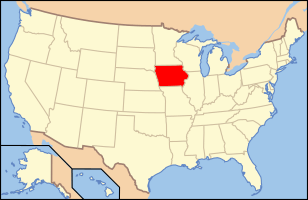
Location of Jones County in Iowa
This is intended to be a complete list of the properties and districts on the National Register of Historic Places in Jones County, Iowa, United States. Latitude and longitude coordinates are provided for many National Register properties and districts; these locations may be seen together in a map.[1]
There are 29 properties and districts listed on the National Register in the county.
- This National Park Service list is complete through NPS recent listings posted August 14, 2020.[2]
| [3] | Name on the Register[4] | Image | Date listed[5] | Location | City or town | Description |
|---|---|---|---|---|---|---|
| 1 | Anamosa Main Street Historic District | 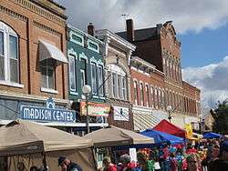 Anamosa Main Street Historic District |
January 29, 2009 (#08001381) |
200 and 300 blocks of W. Main St., 100 block of E. Main St., 100 blocks of N. and S. Ford St., and 100 block of N. Garnavillo St. 42°06′30″N 91°17′13″W |
Anamosa | |
| 2 | Anamosa Public Library | 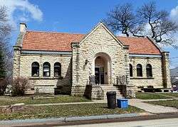 Anamosa Public Library |
May 23, 1983 (#83000380) |
100 E. 1st St. 42°06′24″N 91°17′07″W |
Anamosa | |
| 3 | Antioch School | 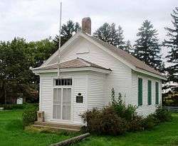 Antioch School |
January 16, 2001 (#00001654) |
Iowa Highway 64, 4 miles (6.4 km) east of Anamosa 42°05′07″N 91°12′50″W |
Anamosa | |
| 4 | Edmund and Mary Ann Walworth Booth House | 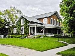 Edmund and Mary Ann Walworth Booth House |
March 13, 2013 (#13000067) |
125 S. Ford St. 42°06′28″N 91°17′08″W |
Anamosa | |
| 5 | Business Part of Olin Historic District | 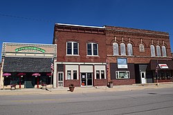 Business Part of Olin Historic District |
November 12, 2014 (#14000907) |
Both sides of 300 blk. of E. Jackson and portion of E. 2nd Sts. 41°59′53″N 91°08′30″W |
Olin | |
| 6 | Dr. Martin H. Caulkins House and Office | 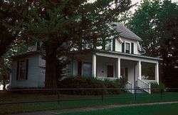 Dr. Martin H. Caulkins House and Office |
March 5, 1982 (#82002625) |
Washington and Main Sts. 42°03′30″N 91°00′16″W |
Wyoming | |
| 7 | Corbett's/Eby's Mill Bridge | 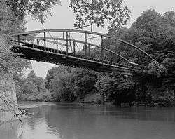 Corbett's/Eby's Mill Bridge |
April 11, 1985 (#85000722) |
Spans the Maquoketa River 42°11′59″N 91°03′32″W |
Scotch Grove Township | |
| 8 | Ely's Stone Bridge | 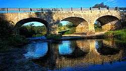 Ely's Stone Bridge |
March 7, 1979 (#79000908) |
Northwest of Monticello at Hardscrabble Rd. 42°15′24″N 91°13′31″W |
Monticello | |
| 9 | Farm Creek Historic District | March 15, 2016 (#16000083) |
Address restricted[6] |
Cascade vicinity | ||
| 10 | Farm No. 1, Iowa Men's Reformatory | 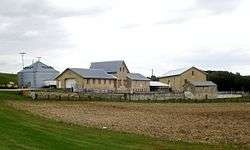 Farm No. 1, Iowa Men's Reformatory |
December 18, 1992 (#92001664) |
County Trunk Highway E28 west of Buffalo Creek 42°06′33″N 91°18′08″W |
Anamosa | |
| 11 | S.S. Farwell House | 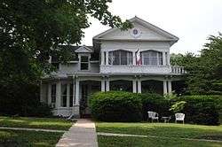 S.S. Farwell House |
April 27, 1979 (#79000909) |
301 N. Chestnut St. 42°14′31″N 91°11′39″W |
Monticello | |
| 12 | Fremont Mill Bridge | 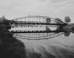 Fremont Mill Bridge |
May 15, 1998 (#98000537) |
Pedestrian path over a small pond in Central Park 42°06′39″N 91°08′22″W |
Anamosa | |
| 13 | John A. Green Estate | 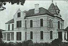 John A. Green Estate |
August 31, 1978 (#78001232) |
West of Anamosa off U.S. Route 151 42°06′40″N 91°21′05″W |
Anamosa | |
| 14 | Hale Bridge | 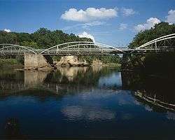 Hale Bridge |
May 15, 1998 (#98000539) |
100th St. over the Wapsipinicon River above Oxford Junction 42°00′16″N 91°03′54″W |
Anamosa | |
| 15 | Iowa Men's Reformatory Cemetery | 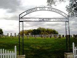 Iowa Men's Reformatory Cemetery |
December 18, 1992 (#92001665) |
County Trunk Highway E28 west of Buffalo Creek 42°06′43″N 91°18′32″W |
Anamosa | |
| 16 | Iowa Men's Reformatory Historic District | 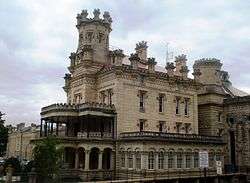 Iowa Men's Reformatory Historic District |
December 18, 1992 (#92001667) |
N. High St. 42°06′41″N 91°17′27″W |
Anamosa | |
| 17 | Jones County Court House |  Jones County Court House |
August 28, 2003 (#03000822) |
500 W. Main St. 42°06′34″N 91°17′24″W |
Anamosa | |
| 18 | Kenny Farmstead Archeological District | March 15, 2016 (#16000082) |
Address restricted[6] |
Cascade vicinity | ||
| 19 | Lower Road Bridge | 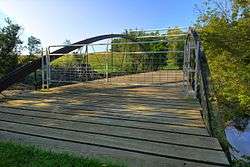 Lower Road Bridge |
May 15, 1998 (#98000536) |
Buffalo Rd. over a branch of the Wapsipinicon River 42°06′53″N 91°18′21″W |
Anamosa | |
| 20 | Moore's Ford Bridge | May 15, 1998 (#98000538) |
25th Ave. over White Water Creek 42°16′47″N 90°55′40″W |
Monticello | ||
| 21 | Odd Fellows Hall | 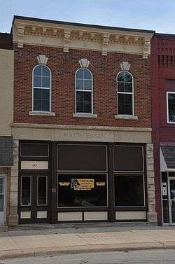 Odd Fellows Hall |
June 27, 1985 (#85001377) |
203 W. 1st St. 42°14′16″N 91°11′27″W |
Monticello | |
| 22 | Rick's Brewery | 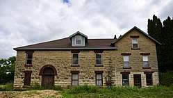 Rick's Brewery |
March 12, 1999 (#99000312) |
12412 Buffalo Rd. 42°06′48″N 91°18′00″W |
Anamosa | |
| 23 | St. Joseph's Roman Catholic Church | 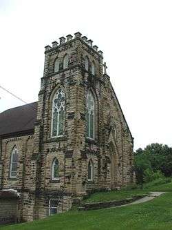 St. Joseph's Roman Catholic Church |
August 24, 2005 (#05000904) |
12472 County Road X28 42°07′06″N 91°21′39″W |
Stone City | |
| 24 | St. Luke's Methodist Church | 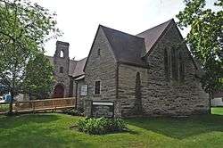 St. Luke's Methodist Church |
January 17, 2002 (#01001461) |
211 N. Sycamore 42°14′26″N 91°11′18″W |
Monticello | |
| 25 | Scotch Grove Historic District | 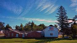 Scotch Grove Historic District |
February 5, 2014 (#13001137) |
Junction of Iowa Highway 38, 116th Avenue, and County Road E17 42°10′21″N 91°06′26″W |
Scotch Grove | |
| 26 | Col. William T. and Elizabeth C. Shaw House | 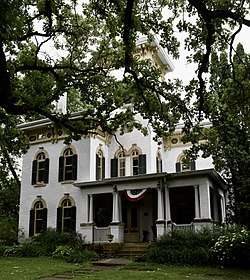 Col. William T. and Elizabeth C. Shaw House |
November 27, 1992 (#92001636) |
509 S. Oak St. 42°06′07″N 91°16′18″W |
Anamosa | |
| 27 | State Quarry, Iowa Men's Reformatory | December 18, 1992 (#92001666) |
Unnamed road along the eastern side of Buffalo Creek northwest of Anamosa 42°07′23″N 91°19′08″W |
Anamosa | ||
| 28 | Stone City Historic District | 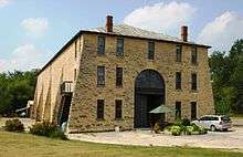 Stone City Historic District |
November 21, 2008 (#08001099) |
12828-12573 Stone City Rd., 12392-12340 Dearborn Rd., and 12381-12551 County Road X28 42°06′54″N 91°21′17″W |
Stone City | |
| 29 | Wapsipinicon State Park Historic District |  Wapsipinicon State Park Historic District |
September 22, 2014 (#14000669) |
21301 Cty. Rd. E34 42°05′43″N 91°17′08″W |
Anamosa |
See also
| Wikimedia Commons has media related to National Register of Historic Places in Jones County, Iowa. |
References
- The latitude and longitude information provided in this table was derived originally from the National Register Information System, which has been found to be fairly accurate for about 99% of listings. Some locations in this table may have been corrected to current GPS standards.
- "National Register of Historic Places: Weekly List Actions". National Park Service, United States Department of the Interior. Retrieved on August 14, 2020.
- Numbers represent an ordering by significant words. Various colorings, defined here, differentiate National Historic Landmarks and historic districts from other NRHP buildings, structures, sites or objects.
- "National Register Information System". National Register of Historic Places. National Park Service. April 24, 2008.
- The eight-digit number below each date is the number assigned to each location in the National Register Information System database, which can be viewed by clicking the number.
- Federal and state laws and practices restrict general public access to information regarding the specific location of this resource. In some cases, this is to protect archeological sites from vandalism, while in other cases it is restricted at the request of the owner. See: Knoerl, John; Miller, Diane; Shrimpton, Rebecca H. (1990), Guidelines for Restricting Information about Historic and Prehistoric Resources, National Register Bulletin, National Park Service, U.S. Department of the Interior, OCLC 20706997.
| Topics | |
|---|---|
| Lists by state |
|
| Lists by insular areas | |
| Lists by associated state | |
| Other areas | |
| Related | |
| |
Municipalities and communities of Jones County, Iowa, United States | ||
|---|---|---|
| Cities | Map of Iowa highlighting Jones County | |
| Townships | ||
| CDP | ||
| Other unincorporated communities | ||
| Footnotes | ‡This populated place also has portions in an adjacent county or counties | |
This article is issued from Wikipedia. The text is licensed under Creative Commons - Attribution - Sharealike. Additional terms may apply for the media files.