National Register of Historic Places listings in Harford County, Maryland
This is a list of the National Register of Historic Places listings in Harford County, Maryland.
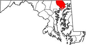
Location of Harford County in Maryland
This is intended to be a complete list of the properties and districts on the National Register of Historic Places in Harford County, Maryland, United States. Latitude and longitude coordinates are provided for many National Register properties and districts; these locations may be seen together in a map.[1]
There are 79 properties and districts listed on the National Register in the county, including one National Historic Landmark called Sion Hill.[2]
| Allegany - Anne Arundel - Baltimore (city) - Baltimore County - Calvert - Caroline - Carroll - Cecil - Charles - Dorchester - Frederick - Garrett - Harford - Howard - Kent - Montgomery - Prince George's - Queen Anne's - Somerset - St. Mary's - Talbot - Washington - Wicomico - Worcester |
- This National Park Service list is complete through NPS recent listings posted August 14, 2020.[3]
Current listings
| [4] | Name on the Register[5] | Image | Date listed[6] | Location | City or town | Description |
|---|---|---|---|---|---|---|
| 1 | James B. Baker House |  James B. Baker House |
December 10, 1982 (#82001593) |
452 W. Bel Air Ave. 39°30′45″N 76°10′25″W |
Aberdeen | |
| 2 | Bel Air Armory |  Bel Air Armory |
September 25, 1985 (#85002667) |
N. Main St. 39°32′15″N 76°21′01″W |
Bel Air | |
| 3 | Bel Air Courthouse Historic District |  Bel Air Courthouse Historic District |
July 25, 1985 (#85001617) |
Office, Courtland, and Main Sts. 39°32′08″N 76°20′59″W |
Bel Air | |
| 4 | Berkley Crossroads Historic District |  Berkley Crossroads Historic District |
July 17, 2003 (#03000649) |
Berkley Road and Castleton Rd. 39°39′46″N 76°12′19″W |
Darlington | |
| 5 | Berkley School |  Berkley School |
July 22, 1988 (#88001011) |
Castleton Rd., Maryland Route 623 39°39′29″N 76°12′21″W |
Darlington | |
| 6 | Best Endeavor |  Best Endeavor |
December 28, 1990 (#90001993) |
1612 Calvary Rd. 39°30′12″N 76°15′55″W |
Churchville | |
| 7 | Bon Air |  Bon Air |
November 10, 1977 (#77000697) |
Laurel Brook Rd. 39°30′28″N 76°25′00″W |
Fallston | |
| 8 | Broad Creek Soapstone Quarries |  Broad Creek Soapstone Quarries |
May 12, 1975 (#75000903) |
Address Restricted |
Whiteford | |
| 9 | Broom's Bloom |  Broom's Bloom |
December 19, 1991 (#91001778) |
1616 S. Fountain Green Rd. 39°30′44″N 76°17′01″W |
Bel Air | |
| 10 | Chestnut Ridge |  Chestnut Ridge |
December 1, 1983 (#83003780) |
3850 W. Chapel Rd. 39°33′34″N 76°10′53″W |
Aberdeen | |
| 11 | Church of the Holy Trinity |  Church of the Holy Trinity |
December 27, 2002 (#02001580) |
2929 Level Rd. 39°33′39″N 76°14′48″W |
Churchville | |
| 12 | Churchville Presbyterian Church |  Churchville Presbyterian Church |
August 21, 1986 (#86001733) |
Intersection of Maryland Routes 22 and 136 39°33′34″N 76°15′10″W |
Churchville | |
| 13 | D. H. Springhouse |  D. H. Springhouse |
May 8, 1973 (#73000923) |
About 6 miles (9.7 km) northeast of Bel Air on Sandy Hook Rd. 39°37′17″N 76°18′37″W |
Bel Air | |
| 14 | Darlington Historic District |  Darlington Historic District |
September 10, 1987 (#87001571) |
Main St., Shuresville Rd., Quaker Ln., Richmond Ave., and Trappe Church Rd. 39°38′23″N 76°12′03″W |
Darlington | |
| 15 | Deer Creek Friends Meetinghouse |  Deer Creek Friends Meetinghouse |
April 23, 1980 (#80001817) |
Maryland Route 161 39°38′46″N 76°12′19″W |
Darlington | |
| 16 | Dibb House |  Dibb House |
March 18, 1980 (#80001812) |
East of Bel Air at 1737 Churchville Rd. 39°32′56″N 76°18′11″W |
Bel Air | |
| 17 | Fair Meadows |  Fair Meadows |
November 25, 1980 (#80004255) |
Creswell Rd. 39°29′57″N 76°15′58″W |
Creswell | |
| 18 | Finney Houses Historic District |  Finney Houses Historic District |
June 16, 1989 (#89000502) |
Glenville Rd. near its junction with Maryland Route 155 39°34′20″N 76°14′20″W |
Churchville | |
| 19 | Gladden Farm |  Gladden Farm |
May 28, 1993 (#93000444) |
3881 Rocks Station Rd. 39°38′27″N 76°24′22″W |
Street | |
| 20 | Graham-Crocker House |  Graham-Crocker House |
March 17, 1980 (#80001813) |
30 N. Main St. 39°32′12″N 76°21′01″W |
Bel Air | |
| 21 | Gray Gables |  Gray Gables |
March 27, 1986 (#86000582) |
4528 Conowingo Rd. 39°39′13″N 76°13′15″W |
Darlington | |
| 22 | Graystone Lodge |  Graystone Lodge |
August 30, 2007 (#07000858) |
1118 Bel Air Rd. 39°30′44″N 76°22′24″W |
Bel Air | |
| 23 | Griffith House |  Griffith House |
November 14, 1978 (#78001465) |
Southwest of Aberdeen at 1120 Old Philadelphia Rd. 39°29′18″N 76°11′41″W |
Aberdeen | |
| 24 | Gunpowder Meetinghouse |  Gunpowder Meetinghouse |
June 5, 1974 (#74000954) |
Magnolia Rd. 39°24′13″N 76°18′29″W |
Aberdeen Proving Ground | |
| 25 | Harford Furnace Historic District |  Harford Furnace Historic District |
July 18, 1990 (#90001020) |
Creswell and Goat Hill Rds. 39°29′36″N 76°15′38″W |
Bel Air | |
| 26 | Harford National Bank | _-_Harford_National_Bank%2C_Bel_Air%2C_Harford_County%2C_MD.jpg) Harford National Bank |
March 20, 1980 (#80001814) |
Wall and Courtland Sts. 39°32′07″N 76°20′59″W |
Bel Air | Richardsonian Romanesque bank building now replaced by a court building |
| 27 | Havre de Grace Historic District |  Havre de Grace Historic District |
March 25, 1982 (#82002815) |
Roughly bounded by Chesapeake Bay, the Susquehanna River, U.S. Route 40, and Stokes, Juniata, and Superior Sts. 39°32′49″N 76°05′29″W |
Havre de Grace | |
| 28 | Havre de Grace Lighthouse | 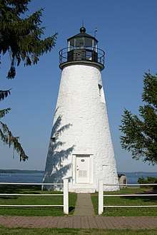 Havre de Grace Lighthouse |
April 2, 1976 (#76000999) |
Concord and Lafayette Sts. 39°32′26″N 76°05′07″W |
Havre de Grace | |
| 29 | Hays House |  Hays House |
January 3, 1980 (#80001815) |
324 S. Kenmore Ave. 39°31′57″N 76°20′52″W |
Bel Air | |
| 30 | Hays-Heighe House |  Hays-Heighe House |
February 11, 1972 (#72000581) |
401 Thomas Run Rd. 39°33′37″N 76°17′00″W |
Bel Air | |
| 31 | Heighe House |  Heighe House |
November 1, 1990 (#90001568) |
Junction of Southampton and Moores Mill Rds. 39°33′00″N 76°20′17″W |
Bel Air | |
| 32 | Hidden Valley Farm |  Hidden Valley Farm |
January 17, 1983 (#83002950) |
2916 Green Rd. 39°31′35″N 76°29′59″W |
Baldwin | |
| 33 | Husband Flint Mill Site | Husband Flint Mill Site |
June 18, 1975 (#75000902) |
Address Restricted |
Kalmia | |
| 34 | Ivory Mills |  Ivory Mills |
August 29, 1997 (#97000968) |
4916 Harford Creamery Rd. 39°40′28″N 76°32′15″W |
White Hall | |
| 35 | Jericho Covered Bridge |  Jericho Covered Bridge |
September 13, 1978 (#78001444) |
East of Kingsville on Jericho Rd. 39°27′34″N 76°23′16″W |
Jerusalem | |
| 36 | Jerusalem Mill Village |  Jerusalem Mill Village |
August 20, 1987 (#87001400) |
Jerusalem and Jericho Rds. 39°27′41″N 76°23′23″W |
Jerusalem | |
| 37 | Joshua's Meadows |  Joshua's Meadows |
December 21, 1982 (#82001594) |
300 N. Tollgate Rd. 39°31′18″N 76°21′54″W |
Bel Air | |
| 38 | Ladew Topiary Gardens and House |  Ladew Topiary Gardens and House |
May 13, 1976 (#76001002) |
3535 Jarrettsville Pike (Maryland Route 146) 39°34′52″N 76°30′44″W |
Taylor | Historic home and 1930s topiary gardens on a 250-acre (1.0 km2) estate. |
| 39 | Liriodendron |  Liriodendron |
September 27, 1980 (#80001816) |
501 and 502 W. Gordon St. 39°32′01″N 76°21′40″W |
Bel Air | |
| 40 | Little Falls Meetinghouse |  Little Falls Meetinghouse |
May 7, 1980 (#80001818) |
Old Fallston Rd. 39°30′33″N 76°24′23″W |
Fallston | |
| 41 | Lower Deer Creek Valley Historic District |  Lower Deer Creek Valley Historic District |
November 3, 1993 (#93001143) |
Roughly bounded by the Susquehanna River, Maryland Route 543, and Harmony, Church, and Trappe Rds. 39°36′43″N 76°14′05″W |
Darlington | |
| 42 | MARTHA LEWIS (skipjack) | December 11, 2008 (#08001175) |
Millard Tydings Memorial Park, Commerce St. at S. Strawberry La. 39°32′18″N 76°05′25″W |
Havre de Grace | Chesapeake Bay Skipjack Fleet TR | |
| 43 | McComas Institute |  McComas Institute |
September 8, 1980 (#80001819) |
North of Joppa on Singer Rd. 39°28′02″N 76°21′30″W |
Joppa | |
| 44 | Medical Hall Historic District |  Medical Hall Historic District |
August 28, 1973 (#73000926) |
West of Churchville off Maryland Route 154 39°34′24″N 76°16′20″W |
Churchville | |
| 45 | Mill Green Historic District |  Mill Green Historic District |
June 3, 1993 (#93000445) |
Junction of Mill Green and Prospect Rds. 39°39′50″N 76°19′34″W |
Street | |
| 46 | Mount Adams |  Mount Adams |
October 27, 1988 (#88002062) |
1912 Fountain Green Rd. 39°30′27″N 76°16′52″W |
Bel Air | |
| 47 | My Lady's Manor |  My Lady's Manor |
April 15, 1978 (#78001445) |
Maryland Route 138 39°35′15″N 76°34′16″W |
Jarrettsville | |
| 48 | Nelson-Reardon-Kennard House |  Nelson-Reardon-Kennard House |
April 15, 1991 (#91000001) |
3604 Philadelphia Rd. 39°27′51″N 76°16′45″W |
Abingdon | |
| 49 | Norris-Stirling House |  Norris-Stirling House |
May 30, 1979 (#79001135) |
Ring Factory Rd. 39°29′26″N 76°21′31″W |
Bel Air | |
| 50 | Odd Fellows Lodge |  Odd Fellows Lodge |
August 22, 1975 (#75000901) |
21 Pennsylvania Ave. 39°32′13″N 76°20′56″W |
Bel Air | |
| 51 | Old Joppa Site |  Old Joppa Site |
August 24, 1979 (#79001136) |
Address Restricted |
Joppatowne | |
| 52 | Olney |  Olney |
July 9, 1987 (#87001197) |
1001 Old Joppa Rd. 39°28′39″N 76°22′11″W |
Joppa | |
| 53 | Pooles Island Lighthouse |  Pooles Island Lighthouse |
February 19, 1997 (#97000060) |
Northwestern portion of Poole's Island and southeast of Rickett Point at Aberdeen Proving Ground 39°17′26″N 76°15′59″W |
Edgewood | |
| 54 | Poplar Hill |  Poplar Hill |
May 28, 1976 (#76000998) |
115 Poplar Hill Rd. 39°29′46″N 76°10′17″W |
Aberdeen | |
| 55 | Presbury Meetinghouse |  Presbury Meetinghouse |
May 23, 1974 (#74000955) |
Austin and Parrish Rds. 39°23′15″N 76°18′24″W |
Aberdeen Proving Ground | |
| 56 | Priest Neal's Mass House and Mill Site |  Priest Neal's Mass House and Mill Site |
March 15, 1990 (#90000352) |
2618 Cool Spring Rd. 39°35′55″N 76°15′33″W |
Bel Air | |
| 57 | Proctor House |  Proctor House |
March 23, 1990 (#90000376) |
54 E. Gordon St. 39°32′24″N 76°21′06″W |
Bel Air | |
| 58 | Rigbie House |  Rigbie House |
August 14, 1973 (#73000925) |
Southeast of Berkley off Maryland Route 623 39°39′37″N 76°12′12″W |
Berkley | |
| 59 | Rockdale |  Rockdale |
June 30, 1982 (#82002814) |
North of Fallston at 1724 Carrs Mill Rd. 39°32′03″N 76°24′19″W |
Fallston | |
| 60 | St. George's Parish Vestry House |  St. George's Parish Vestry House |
March 26, 1976 (#76001001) |
1522 Perryman Rd. 39°28′27″N 76°12′16″W |
Perryman | |
| 61 | St. Ignatius Church |  St. Ignatius Church |
April 16, 1974 (#74000956) |
533 E. Jarrettsville Rd. 39°34′25″N 76°21′19″W |
Forest Hill | |
| 62 | St. Mary's Church | _Left_Side.JPG) St. Mary's Church |
March 30, 1973 (#73000928) |
South of Emmorton on Maryland Route 24 39°29′16″N 76°19′04″W |
Emmorton | |
| 63 | Silver Houses Historic District |  Silver Houses Historic District |
September 7, 1984 (#84001800) |
South of Darlington on Maryland Route 161 39°36′22″N 76°11′47″W |
Darlington | |
| 64 | Sion Hill | 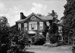 Sion Hill |
April 30, 1990 (#90000608) |
2026 Level Rd. 39°33′42″N 76°07′32″W |
Havre de Grace | Historic home of U.S. Navy officers including Commodore John Rodgers. |
| 65 | Slate Ridge School |  Slate Ridge School |
July 16, 1987 (#87000657) |
Old Pylesville Rd. 39°42′45″N 76°20′25″W |
Whiteford | |
| 66 | Sophia's Dairy |  Sophia's Dairy |
September 20, 1973 (#73000922) |
Southwest of Aberdeen off U.S. Route 40 39°28′24″N 76°14′03″W |
Aberdeen | |
| 67 | Southern Terminal, Susquehanna and Tidewater Canal |  Southern Terminal, Susquehanna and Tidewater Canal |
May 28, 1976 (#76001000) |
North of Erie St. between Conesteo St. and the Susquehanna River 39°33′24″N 76°05′41″W |
Havre de Grace | |
| 68 | Col. John Streett House |  Col. John Streett House |
July 16, 1990 (#90001022) |
Northern side of Holy Cross Rd. east of Deer Creek 39°39′27″N 76°26′04″W |
Street | |
| 69 | Swansbury |  Swansbury |
July 15, 1994 (#94000730) |
Beard's Hill Rd. Extended, northeast of Aberdeen 39°31′18″N 76°09′11″W |
Aberdeen | |
| 70 | Thomas Run Church |  Thomas Run Church |
January 3, 1978 (#78001466) |
Northeast of Bel Air off Maryland Route 136 39°35′32″N 76°17′34″W |
Bel Air | |
| 71 | Tudor Hall |  Tudor Hall |
March 14, 1973 (#73000924) |
Northeast of Bel Air off Maryland Route 22 39°33′15″N 76°18′11″W |
Bel Air | |
| 72 | The Vineyard |  The Vineyard |
July 22, 1994 (#94000762) |
1201 Conowingo Rd. (U.S. Route 1) 39°33′56″N 76°20′34″W |
Bel Air | |
| 73 | Webster's Forest |  Webster's Forest |
September 1, 1983 (#83002951) |
500 Asbury Rd. 39°32′32″N 76°15′51″W |
Churchville | |
| 74 | Whitaker's Mill Historic District |  Whitaker's Mill Historic District |
July 16, 1990 (#90001021) |
1210, 1212, and 1213 Whitaker Mill Rd. 39°29′51″N 76°21′15″W |
Joppa | |
| 75 | Whiteford-Cardiff Historic District |  Whiteford-Cardiff Historic District |
November 15, 2005 (#05001278) |
Whiteford Rd., Platted Parry St., Quarry Rd., west of Main St.; split between Maryland and Pennsylvania 39°42′56″N 76°20′19″W |
Whiteford | |
| 76 | Wildfell |  Wildfell |
September 20, 1973 (#73000927) |
Northwest of Darlington on U.S. Route 1 39°39′04″N 76°13′11″W |
Darlington | |
| 77 | Winsted |  Winsted |
September 19, 1979 (#79003266) |
North of Aberdeen at 3844 W. Chapel Rd. 39°33′36″N 76°10′54″W |
Aberdeen | |
| 78 | Woodside |  Woodside |
November 1, 1979 (#79001134) |
Northwest of Abingdon at 400 Singer Rd 39°28′47″N 76°19′22″W |
Abingdon | |
| 79 | Woodview |  Woodview |
October 25, 1990 (#90001574) |
1236 Somerville Rd. 39°29′47″N 76°20′56″W |
Bel Air |
See also
| Wikimedia Commons has media related to National Register of Historic Places in Harford County, Maryland. |
References
- The latitude and longitude information provided in this table was derived originally from the National Register Information System, which has been found to be fairly accurate for about 99% of listings. Some locations in this table may have been corrected to current GPS standards.
- "National Register Information System". National Register of Historic Places. National Park Service. July 9, 2010.
- "National Register of Historic Places: Weekly List Actions". National Park Service, United States Department of the Interior. Retrieved on August 14, 2020.
- Numbers represent an ordering by significant words. Various colorings, defined here, differentiate National Historic Landmarks and historic districts from other NRHP buildings, structures, sites or objects.
- "National Register Information System". National Register of Historic Places. National Park Service. April 24, 2008.
- The eight-digit number below each date is the number assigned to each location in the National Register Information System database, which can be viewed by clicking the number.
| Topics |  | |
|---|---|---|
| Lists by county | ||
| Lists by city | ||
| Other lists | ||
| ||
Municipalities and communities of Harford County, Maryland, United States | ||
|---|---|---|
| Cities | | |
| Town | ||
| CDPs | ||
| Other communities | ||
This article is issued from Wikipedia. The text is licensed under Creative Commons - Attribution - Sharealike. Additional terms may apply for the media files.