Mountains and hills of Scotland
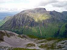
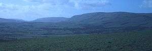
Scotland is the most mountainous country in the United Kingdom. The area north and west of the Highland Boundary Fault is known as the Highlands, and contains the country's main mountain ranges. Scotland's mountain ranges, in a rough north to south direction, are: The Highlands & Islands, The Hills of the Central Lowlands, the Southern Uplands. The zone includes Britain's highest peaks, especially Ben Nevis (Beinn Nibheis), standing at 4,411 ft (1,344.5 m), with several similar peaks in the Cairngorms.
Some of the most spectacular mountains occur in the northwest highlands, especially on Skye, the largest island off the coast. On the mainland nearby lie some great ranges based on the Torridonian sandstone, a Precambrian rock which overlies yet older rocks such as the Lewisian gneiss. Some of the highest peaks, such as Beinn Eighe, are crowned by white quartzite, which gives those peaks a distinctive appearance. The trend continues to the north, with larger caps of the white rock at Foinaven and Arkle. Some of the quartzite contains fossilised worm burrows. It is known as pipe rock and is around 500 million years old.
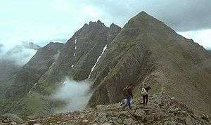
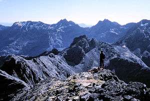
The formation continues to the north with gigantic peaks such as An Teallach near Ullapool, and Stac Pollaidh in Sutherland. The Torridonian rocks continue south to Applecross opposite Skye, where similar massive mountains occur. The Black Cuillin are mainly composed of basalt and gabbro; the latter is a very rough rock which makes for superb grip for mountaineers. It is from the dark colour of the gabbro that the Black Cuillin receive their name. The summits of the Cuillin are bare rock, jagged in outline and with steep cliffs and deep cut corries and gullies.
- The Northwest Highlands, lying to the north and west of the Great Glen
- The Cuillin, on the Isle of Skye
- The Grampians, the main belt of mountains across the centre of Scotland; also includes the Cairngorms
- The Torridon Hills of Wester Ross
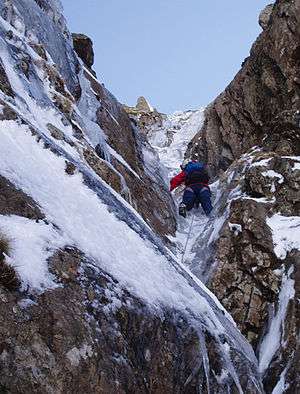
There are many notable individual peaks, and many exceed 1,000 metres (3,281 ft) in height, so qualifying as Munros. Ben Nevis exceeds 1,300 metres (4,265 ft). To the south, Glen Coe has many notable mountains, such as Buachaille Etive Mòr and Bidean nam Bian, both of which are Munros. There is also a famous ridge walk, the Aonach Eagach, on the opposite side of the glen. The ridge is one of the most popular scrambles in the entire country; it is a craggy arête with few escape routes.
The Grampians extend from southwest to northeast between the Highland Boundary Fault and the Great Glen, occupying almost half of the land area of Scotland and including the Cairngorms and the Lochaber hills. The range includes many of the highest mountains in the British Isles, including Ben Nevis and Ben Macdui, the two highest. The Cairngorm Plateau is the highest, coldest and snowiest plateau in the British Isles.
Hills of the Central Lowlands
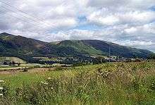
The southern and eastern parts of Scotland are usually referred to as the Scottish Lowlands, but these areas also have significant ranges of hills, although these are lower than the Highland mountains. Because they are much closer to towns and cities, they are more popular for hill walking and rambling than the more distant mountains of the northern Highlands.
- Sidlaw Hills, north of Dundee but south east of the Highland Boundary Fault
- Ochil Hills, east of Stirling
- Campsie Fells, north of Glasgow
In addition to the main ranges, there are numerous individual hills in the Lowlands, often volcanic in origin. Many are known by the Scots word Law, meaning hill
Southern Uplands
The Southern Uplands form a continuous belt of hills across southern Scotland from Galloway to the Borders. The Uplands are divided into several local ranges. The heartland of the Galloway hills lies to the north of Loch Trool, and many excellent walks start from the extensive car park by Bruce's Stone. There are three ridges which run northwards from the Loch Trool/Loch Dee/Clatteringshaws area: The Awful Hand on the west, The Rhinns of Kells to the east, and the Dungeon hills in between.
- Galloway Hills
- Lowther Hills
- Moffat Hills
- Pentland Hills
- Moorfoot Hills
- Lammermuir Hills
- Cheviot Hills, which lie mostly in England and form part of the border between the two countries
Scotland's highest mountains
The ten highest mountains in Scotland are also the ten highest in the UK:
1. Ben Nevis (Beinn Nibheis), 4,411.1 ft (1,344.5 m)[1]
2. Ben Macdui (Beinn Macduibh), 4,295 ft (1,309 m)[2]
3. Braeriach (Am Bràigh Riabhach), 4,252 ft (1,296 m)[3]
4. Cairn Toul (Càrn an t-Sabhail), 4,236 ft (1,291 m)[4]
5. Sgòr an Lochain Uaine, 4,127 ft (1,258 m)[5]
6. Cairn Gorm (An Càrn Gorm), 4,084 ft (1,244.8 m)[6]
7. Aonach Beag, 4,049 ft (1,234 m)[7]
8. Aonach Mòr, 4,004 ft (1,220.4 m)[8]
9. Càrn Mòr Dearg, 4,003 ft (1,220 m)[9]
10. Ben Lawers (Beinn Labhair), 3,983 ft (1,214 m)[10]
Listings
Scottish peaks are categorised in the following hill lists. A peak may qualify for inclusion in more than one list.
- The Munros are the most significant hills in Scotland over 3,000 feet (914.4 m), according to original compiler Sir Hugh Munro. The list was first drawn up in 1891, and is modified from time to time by the Scottish Mountaineering Club (SMC). It currently comprises 282 peaks,[11] following the demotion of Sgurr nan Ceannaichean in September 2009 and of Beinn a' Chlaidheimh in 2012.[12]
- The Corbetts are hills in Scotland between 2,500 and 3,000 feet (762 and 914.4 m), with a relative height of at least 500 feet (152.4 m). The list is maintained by the SMC. There are currently 221 hills.
- The Grahams are hills in Scotland between 2,000 and 2,500 feet (609.6 and 762 m), with a relative height of at least 150 metres (492 ft). The list of hills fitting these criteria was first published by Alan Dawson in The Relative Hills of Britain.[13] under the provisional name Elsies (LCs, short for Lesser Corbetts). They were later named Grahams after the late Fiona Torbet (née Graham) who had compiled a similar list around the same time.[14] The SMC incorporated the list into Munro's Tables[15] in 1997 but Dawson continues to maintain the list. There were originally 224 Grahams, but the current total stands at 221 after Corwharn, Ben Aslak and Ladylea Hill were surveyed as falling short of 609.6 m[16]
- The Donalds are hills in the Scottish Lowlands over 2,000 feet (609.6 m). The list was originally compiled by Percy Donald, and is maintained by the SMC. It comprises 89 summits and 51 subsidiary tops, giving a total of 140 hills.
- The Marilyns are hills in the British Isles that have a relative height of at least 150 m, regardless of distance, absolute height or merit. The list was compiled and is maintained by Alan Dawson. There are 1,216 Scottish Marilyns, see List of Marilyns in Scotland.
References
- "Great Britain's tallest mountain is taller". Ordnance Survey. 2016-03-18. Retrieved 20 June 2019.
- "Ben Macdui (Beinn Macduibh)". Hill Bagging - the online version of the Database of British and Irish Hills (DoBIH). 2019. Retrieved 20 June 2019.
- "Braeriach (Am Bràigh Riabhach)". Hill Bagging - the online version of the Database of British and Irish Hills (DoBIH). 2019. Retrieved 20 June 2019.
- "Cairn Toul (Càrn an t-Sabhail)". Hill Bagging - the online version of the Database of British and Irish Hills (DoBIH). 2019. Retrieved 20 June 2019.
- "Sgòr an Lochain Uaine". Hill Bagging - the online version of the Database of British and Irish Hills (DoBIH). 2019. Retrieved 20 June 2019.
- "Cairn Gorm". Hill Bagging - the online version of the Database of British and Irish Hills (DoBIH). 2019. Retrieved 20 June 2019.
- "Aonach Beag". Hill Bagging - the online version of the Database of British and Irish Hills (DoBIH). 2019. Retrieved 20 June 2019.
- "Aonach Mòr". Hill Bagging - the online version of the Database of British and Irish Hills (DoBIH). 2019. Retrieved 20 June 2019.
- "Càrn Mòr Dearg". Hill Bagging - the online version of the Database of British and Irish Hills (DoBIH). 2019. Retrieved 20 June 2019.
- "Ben Lawers (Beinn Labhair)". Hill Bagging - the online version of the Database of British and Irish Hills (DoBIH). 2019. Retrieved 20 June 2019.
- "SMC: List of Munros". Archived from the original on 2009-08-27. Retrieved 2009-08-27.
- Beinn a' Chlaidheimh on munromagic.com
- Dawson, Alan (1992). The Relative Hills of Britain. Milnthorpe: Cicerone Press. ISBN 1-85284-068-4. Archived from the original on 2010-09-21.
- Dawson, Alan (1999). The Grahams and the New Donalds. Cambuskenneth, Stirling: TACit Press. ISBN 0-9534376-0-4. Archived from the original on 2008-03-27. Retrieved 2008-04-23.
- Bearhop, D.A. (1997). Munro's Tables. Scottish Mountaineering Club & Trust. ISBN 0-907521-53-3.
- The Grahams and the Donalds. Scottish Mountaineering Trust. 2015. ISBN 978-1-907233-19-7.
External links
- Scottish Mountaineering Club - The SMC maintain the lists of Munros, Munro Tops, Furths, Corbetts and Donalds. They also keep a record of Completionists.
- Walkhighlands – Features podcasts giving the correct pronunciation and place-name meanings, a 3D visualisation of every route, gradient profiles and route downloads for GPS devices.
- MunroMagic.com – Munro, Corbett and Graham descriptions, pictures, location maps, walking routes and weather reports.
- Hill Bagging - the online version of the Database of British and Irish Hills - Survey reports, the change control database and the GPS database are on Hill Bagging.
- The Munros and Tops 1891–1997 – Spreadsheet showing changes in successive editions of Munros Tables.
- Ordnance Survey Munro Blog - OS is Britain's mapping agency. They make the most up-to-date and accurate maps of the United Kingdom. They have also produced a blog on the Munros.
- Harold Street Munros Lists of GPS waypoints + Grid References for walking in UK mountains and hills in various GPS file formats.
- ScottishHills.com – Hillwalking forum with Munro, Corbett, Graham and Donald, Sub 200's log, maps and trip reports.
See also
| Wikimedia Commons has media related to Mountains of Scotland. |
- Geography of Scotland
- List of mountains of the British Isles by height
- Lists of mountains and hills in the British Isles
- Lists of mountains in Ireland
- List of Munro mountains in Scotland
- List of Murdos (mountains)
- List of Corbetts (mountains)
- List of Grahams (mountains)
- List of Donald mountains in Scotland
- List of Furth mountains in the British Isles
- List of P600 mountains in the British Isles
| British Isles | 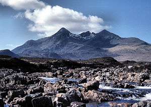 | |
|---|---|---|
| Scotland | ||
| Outside Scotland | ||
| England | ||
| Ireland | ||
| County tops | ||