Mount Blaxland (New South Wales)
Mount Blaxland, actually a hill, is located about 25 kilometres south of Lithgow at longitude -33.548500061, latitude 150.117904663.[1] It was the furthest point reached by Blaxland, Lawson, and Wentworth on their historic 1813 crossing of the Blue Mountains.[2]
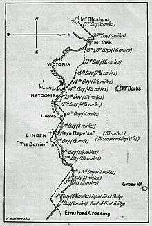
A sketch of Blaxland, Lawson and Wentworth's route across the Blue Mountains in 1813 prepared by F Walker in 1913. The Great Western Road has been inserted to show how closely it has followed the track of the explorers in its general direction.
The name was bestowed upon it by Surveyor-General George Evans when, later in 1813, Evans arrived at the terminal point of Blaxland's expedition. Two other smaller conical shaped hills on the opposite side of a nearby stream were named, by Evans, Wentworth's Sugar-Loaf and Lawson's Sugar-Loaf.[2]
Mount Blaxland is located on private property at South Bownfels, south of Lithgow, owned by Glen Ryan. Glen runs cattle on about 1800 hectares of land.[3]
References
- Geodata U.S. Retrieved 9 March 2014.
- The Journal of Gregory Blaxland, 1813, note 4. Retrieved 9 March 2014.
- Crossing the Blue Mountains: from bush tracks to highways Retrieved 9 March 2014.
External links
- Mt Blaxland. An Interesting Spot. The Sydney Morning Herald 26 December 1929 page 4. Retrieved 9 March 2014.
- Geographical Names Register - Mt Blaxland
- Photo of Mount Blaxland, c.2008. Retrieved 9 March 2014.
- Photo of Mount Blaxland from the south-west, c.2011. Retrieved 9 March 2014.
- Photo of summit of Mount Blaxland showing remains of old cairn, c.2011. Retrieved 9 March 2014.
This article is issued from Wikipedia. The text is licensed under Creative Commons - Attribution - Sharealike. Additional terms may apply for the media files.