Mississippi Highway 69
Mississippi Highway 69 (MS 69) is a state highway in eastern Mississippi. The route starts at the Alabama state line, and travels northwestward to Columbus. MS 69 then goes through downtown Columbus, and ends at U.S. Route 45 (US 45) and US 82 in the west side of the town. Before the road was designated as MS 69 in 1941, it was a gravel road from Columbus to the state line. The road was paved in asphalt in 1953. In 1992, US 82 was realigned, and MS 69 was extended through Columbus to its current northern terminus.
| ||||
|---|---|---|---|---|
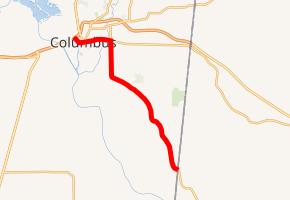
MS 69 highlighted in red | ||||
| Route information | ||||
| Maintained by MDOT | ||||
| Length | 15.56 mi[1] (25.04 km) | |||
| Existed | c. 1941–present | |||
| Major junctions | ||||
| South end | ||||
| North end | ||||
| Location | ||||
| Counties | Lowndes | |||
| Highway system | ||||
| ||||

Route description
| Location | Volume | ||||
|---|---|---|---|---|---|
| Northwest of Weaver Road | 2,100 | ||||
| Southeast of Gipson Lane | 4,700 | ||||
| North of Temple Drive | 7,600 | ||||
| North of Cooper Road | 14,000 | ||||
| South of Airline Road | 13,900 | ||||
| East of Baseball Field Road | 20,000 | ||||
| West of North 24th Street | 17,000 | ||||
| East of 6th Street | 16,000 | ||||
| East of 2nd Street | 11,000 | ||||
| North of Moores Creek Road | 12,000 | ||||
MS 69 starts at the Alabama state line, where Alabama State Route 14 ends.[3] The route turns northwest at Spurlock Road. It travels through the forest, intersecting Weaver Road and Halbert Road. MS 69 moves westward for a short period between Concord Road and East Minnie Vaughn Road. The road then curves slowly towards Columbus, as small streets begin to appear.[4] At Pickensville Road, MS 69 travels north into Columbus, and intersects Fabritek Drive, the entrance to Columbus-Lowndes County Airport. At Yorkville Road, the road meets MS 795's eastern terminus. It soon crosses over the McCrary Vernon Creek and the Alabama Southern Railroad.[5] At MS 182, MS 69 becomes concurrent with it and travels westward. The road soon crosses over Luxapalila Creek and enters downtown Columbus.[5] MS 69 and MS 182 changes into a divided highway at Thirteenth Street. The street then intersects Fifth Street, which becomes US 45 past US 82. MS 182 continues westward on Island Road, while MS 69 travels northwestward. The route ends at US 45 and US 82 at a diamond interchange. The road continues to East Plymouth Road, where it ends at a three-way junction.[4]
All of the route is located in Lowndes County,[6] and is not included as a part of the National Highway System (NHS).[7] The route is legally defined in Mississippi Code § 65-3-3,[8] and all of it is maintained by the Mississippi Department of Transportation (MDOT).[1]
History
A gravel road from Columbus to the Mississippi–Alabama state line has existed since 1928,[9] and it was designated as MS 69 by 1941.[10][11] A $296,187.71 (equivalent to $2,917,449 in 2019) contract awarded by the Mississippi State Highway Commission in 1951 was used to grade the road, add drainage, culverts, and bridges to the route.[12] The road was paved with asphalt by 1953,[13][14] after being proposed four years earlier by the city of Columbus' Chamber of Commerce.[15] The highway caught on fire in 1957, after a wagon carrying coal tar spilled its contents, destroying multiple telephone lines.[16] In 1958, the northern terminus was rerouted out of downtown Columbus, to east of US 82 and MS 50's intersection.[17][18] In 1992, US 82 was realigned to the bypass around Columbus,[19] and MS 69 was extended through Columbus to a diamond interchange in the western part of the town.[20][21]
Major intersections
The entire route is in Lowndes County.
| Location | mi[4] | km | Destinations | Notes | |
|---|---|---|---|---|---|
| | 0.0 | 0.0 | Alabama state line; southern terminus | ||
| Columbus | 10.3 | 16.6 | |||
| 11.3 | 18.2 | Northern terminus of MS 795 | |||
| 12.5 | 20.1 | Southern end of MS 182 concurrency | |||
| 15.1 | 24.3 | Northern end of MS 182 concurrency | |||
| 15.4– 15.6 | 24.8– 25.1 | Diamond interchange; northern terminus | |||
1.000 mi = 1.609 km; 1.000 km = 0.621 mi
| |||||
References
- Planning Division (December 31, 2016). Mississippi Public Roads Selected Statistics Extent, Travel, and Designation (PDF) (Report). Mississippi Department of Transportation. Archived from the original (PDF) on June 13, 2018. Retrieved June 5, 2018.
- Mississippi Department of Transportation (2016). "MDOT Traffic Count Application". Mississippi Department of Transportation. Retrieved June 5, 2018.
- Alabama Department of Transportation (2017). Alabama Official Highway Map (PDF) (Map) (2017–18 ed.). c. 1:823,680. Montgomery: Alabama Department of Transportation. Retrieved June 2, 2018.
- Microsoft; Nokia (June 5, 2018). "Mississippi Highway 69" (Map). Bing Maps. Microsoft. Retrieved June 5, 2018.
- Mississippi Department of Transportation (2014). Columbus, Mississippi (PDF) (Map). c. 1:20,004. Jackson: Mississippi Department of Transportation. Retrieved December 25, 2014.
- Mississippi Department of Transportation (2015). Lowndes County, Mississippi (PDF) (Map). c. 1:63,360. Jackson: Mississippi Department of Transportation. Retrieved June 5, 2018.
- Federal Highway Administration (November 2003). National Highway System: Mississippi (PDF) (Map). c. 1:1,900,800. Washington, DC: Federal Highway Administration. Retrieved December 25, 2014.
- Mississippi Legislature. "Sec. 65-3-3: State Highways Designated". Mississippi Code of 1972 as Amended. Mississippi Legislature. Retrieved December 25, 2014 – via LexisNexis.
- Mississippi State Highway Department (1928). Condition Map of State Highway System (PDF) (Map). Jackson: Mississippi State Highway Department. Retrieved December 20, 2014.
- Mississippi State Highway Department (1940). Road Map of Mississippi (PDF) (Map). Jackson: Mississippi State Highway Department. Retrieved December 20, 2014.
- Mississippi State Highway Department (1941). Road Map of Mississippi (PDF) (Map). Jackson: Mississippi State Highway Department. Retrieved December 20, 2014.
- "Over 2 Million Road Contracts Awarded Here". Clarion-Ledger. Jackson, MS. June 27, 1951. p. 1. Retrieved June 5, 2018 – via Newspapers.com.

- Mississippi State Highway Commission (July 1952). Official Road Map State of Mississippi (PDF) (Map). Jackson: Mississippi State Highway Commission. Retrieved December 20, 2014.
- Mississippi State Highway Commission (1953). Official Road Map State of Mississippi (PDF) (Map). Jackson: Mississippi State Highway Commission. Retrieved December 20, 2014.
- "Ask Hard Surfacing For Highway 69". Clarion-Ledger. Jackson, MS. May 2, 1949. p. 3. Retrieved June 5, 2018 – via Newspapers.com.
- "Highway 69 Catches On Fire". The Greenwood Commonwealth. Associated Press. February 15, 1957. p. 1. Retrieved June 5, 2018 – via Newspapers.com.
- Mississippi State Highway Commission (1957). Official Road Map State of Mississippi (PDF) (Map). Jackson: Mississippi State Highway Commission. Retrieved December 20, 2014.
- Mississippi State Highway Commission (1958). Official Road Map State of Mississippi (PDF) (Map). Jackson: Mississippi State Highway Commission. Retrieved December 20, 2014.
- "U.S. 82 Bypass Around Columbus Ready for Traffic". Clarion-Ledger. Jackson, MS. Associated Press. January 13, 1992. p. 10. Retrieved June 5, 2018 – via Newspapers.com.
- Mississippi State Highway Department (1992). Official Highway Map of Mississippi (PDF) (Map). Jackson: Mississippi State Highway Department. Columbus inset. Retrieved December 20, 2014.
- Mississippi Department of Transportation (1993). Official Highway Map of Mississippi (PDF) (Map) (1993–1994 ed.). Jackson: Mississippi Department of Transportation. Columbus inset. Retrieved December 20, 2014.