Mississippi Highway 26
Mississippi Highway 26 (MS 26) is a state highway in southern Mississippi. It runs from west to east for 81.98 miles (131.93 km), serving the counties of Pearl River, Stone, and George.
| ||||
|---|---|---|---|---|
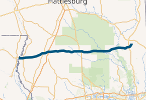
MS 26 highlighted in blue | ||||
| Route information | ||||
| Maintained by MDOT | ||||
| Length | 77.05 mi[1] (124.00 km) | |||
| Major junctions | ||||
| West end | ||||
| North end | ||||
| Location | ||||
| Counties | Pearl River, Stone, George | |||
| Highway system | ||||
| ||||

Major intersections
| County | Location | mi[2] | km | Destinations | Notes |
|---|---|---|---|---|---|
| Pearl River | | 0.0 | 0.0 | Western terminus; Louisiana state line | |
| | 2.9 | 4.7 | |||
| Poplarville | 17.3 | 27.8 | Western end of MS 53 concurrency; northern terminus of MS 53 | ||
| 18.0 | 29.0 | Eastern end of MS 53 concurrency | |||
| 20.2– 20.4 | 32.5– 32.8 | I-59 exit 29 | |||
| Stone | Wiggins | 40.8– 40.9 | 65.7– 65.8 | Diamond interchange | |
| 41.9 | 67.4 | Partial cloverleaf interchange; southern terminus of MS 29 | |||
| | 50.5 | 81.3 | Northern terminus of southern section of MS 15 | ||
| George | | 62.1 | 99.9 | ||
| | 73.6– 73.7 | 118.4– 118.6 | Diamond interchange | ||
| Lucedale | 76.6 | 123.3 | Eastern terminus | ||
1.000 mi = 1.609 km; 1.000 km = 0.621 mi
| |||||
References
- Mississippi Department of Transportation Planning Division (December 31, 2014). Mississippi Public Roads Selected Statistics Extent, Travel, and Designation (PDF) (Report). Mississippi Department of Transportation. Retrieved November 8, 2016.
- Google (November 8, 2016). "Mississippi Highway 26" (Map). Google Maps. Google. Retrieved November 8, 2016.
External links
This article is issued from Wikipedia. The text is licensed under Creative Commons - Attribution - Sharealike. Additional terms may apply for the media files.