Maybee, Michigan
Maybee is a village in southwestern Exeter Township in Monroe County in the U.S. state of Michigan. Maybee was established in 1873 and incorporated as a village in 1899.[8] The population was 562 at the 2010 census.
Maybee, Michigan | |
|---|---|
| Village of Maybee | |
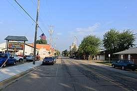 Facing east along Bluebush Road | |
 Location within Monroe County | |
 Maybee Location within the state of Michigan | |
| Coordinates: 42°00′14″N 83°30′56″W | |
| Country | United States |
| State | Michigan |
| County | Monroe |
| Township | Exeter |
| Government | |
| • Type | Village council |
| • President | Leonard Gaylor |
| • Clerk | Julie Hartford |
| Area | |
| • Total | 1.00 sq mi (2.59 km2) |
| • Land | 0.99 sq mi (2.56 km2) |
| • Water | 0.01 sq mi (0.03 km2) |
| Elevation | 636 ft (194 m) |
| Population | |
| • Total | 562 |
| • Estimate (2019)[4] | 532 |
| • Density | 538.46/sq mi (207.94/km2) |
| Time zone | UTC-5 (Eastern (EST)) |
| • Summer (DST) | UTC-4 (EDT) |
| ZIP code(s) | 48159 |
| Area code(s) | 734 |
| FIPS code | 26-52440[5] |
| GNIS feature ID | 0631766[6] |
| Website | Official website |
| Maybee Village Hall | |
|---|---|
 | |
| Location | 9051 Raisin Street |
| Coordinates | 42°00′17″N 83°30′56″W |
| Built | 1912 |
| Designated | March 15, 1988[7] |
Most of the village is served by Monroe Public Schools and is located in the extreme northwest portion of the district, but the westernmost strip of the village is located within the Dundee Community Schools district.[9]
History
Maybee was named for Abram Maybee, who, along with Joseph Klotz, surveyed, platted, and sold the land that became the village between 1873 and 1875. The village was incorporated in 1899. Spurred on by the railroad, the village grew to include a grain elevator, grist mill, stone quarry, sand pit, hotel, three churches, two schools, and several small factories and stores.[10] It is primarily an agricultural community. The grain elevator and quarry are still operating, along with several small businesses and restaurants.
Geography
According to the United States Census Bureau, the village has a total area of 1.01 square miles (2.62 km2), of which 1.00 square mile (2.59 km2) is land and 0.01 square miles (0.03 km2) (0.99%) is water.[11]
Demographics
| Historical population | |||
|---|---|---|---|
| Census | Pop. | %± | |
| 1880 | 200 | — | |
| 1910 | 310 | — | |
| 1920 | 290 | −6.5% | |
| 1930 | 346 | 19.3% | |
| 1940 | 390 | 12.7% | |
| 1950 | 428 | 9.7% | |
| 1960 | 459 | 7.2% | |
| 1970 | 485 | 5.7% | |
| 1980 | 490 | 1.0% | |
| 1990 | 500 | 2.0% | |
| 2000 | 505 | 1.0% | |
| 2010 | 562 | 11.3% | |
| Est. 2019 | 532 | [4] | −5.3% |
| U.S. Decennial Census[12] | |||
2010 census
As of the census[3] of 2010, there were 562 people, 205 households, and 154 families living in the village. The population density was 562.0 inhabitants per square mile (217.0/km2). There were 223 housing units at an average density of 223.0 per square mile (86.1/km2). The racial makeup of the village was 96.6% White, 1.4% African American, 0.5% Native American, 0.4% Asian, 0.4% from other races, and 0.7% from two or more races. Hispanic or Latino of any race were 1.8% of the population.
There were 205 households, of which 42.0% had children under the age of 18 living with them, 59.0% were married couples living together, 13.2% had a female householder with no husband present, 2.9% had a male householder with no wife present, and 24.9% were non-families. 22.0% of all households were made up of individuals, and 5.3% had someone living alone who was 65 years of age or older. The average household size was 2.74 and the average family size was 3.23.
The median age in the village was 34.9 years. 31% of residents were under the age of 18; 5.3% were between the ages of 18 and 24; 26.9% were from 25 to 44; 30.9% were from 45 to 64; and 5.9% were 65 years of age or older. The gender makeup of the village was 49.8% male and 50.2% female.
2000 census
As of the census[5] of 2000, there were 505 people, 170 households, and 126 families living in the village. The population density was 432.3 per square mile (166.7/km2). There were 184 housing units at an average density of 157.5 per square mile (60.7/km2). The racial makeup of the village was 98.42% White, 0.40% African American, 0.20% Pacific Islander, 0.59% from other races, and 0.40% from two or more races. Hispanic or Latino of any race were 1.78% of the population.
There were 170 households, out of which 42.9% had children under the age of 18 living with them, 55.9% were married couples living together, 11.8% had a female householder with no husband present, and 25.3% were non-families. 18.8% of all households were made up of individuals, and 4.7% had someone living alone who was 65 years of age or older. The average household size was 2.96 and the average family size was 3.42.
In the village, the population was spread out, with 31.1% under the age of 18, 11.1% from 18 to 24, 34.1% from 25 to 44, 17.8% from 45 to 64, and 5.9% who were 65 years of age or older. The median age was 31 years. For every 100 females, there were 114.0 males. For every 100 females age 18 and over, there were 118.9 males.
The median income for a household in the village was $50,962, and the median income for a family was $60,000. Males had a median income of $42,386 versus $23,929 for females. The per capita income for the village was $18,716. About 2.4% of families and 4.4% of the population were below the poverty line, including 3.2% of those under age 18 and 3.2% of those age 65 or over.
Gallery
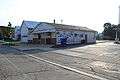 Monroe County Library Maybee Branch, Raisin St.
 US Post Office, Mill St.
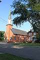 St. Joseph Catholic Church and parish office, Joseph St.
References
- Village of Maybee (2020). "Village Council". Retrieved April 9, 2020.
- "2019 U.S. Gazetteer Files". United States Census Bureau. Retrieved July 25, 2020.
- "U.S. Census website". United States Census Bureau. Retrieved 2012-11-25.
- "Population and Housing Unit Estimates". United States Census Bureau. May 24, 2020. Retrieved May 27, 2020.
- "U.S. Census website". United States Census Bureau. Retrieved 2008-01-31.
- "US Board on Geographic Names". United States Geological Survey. 2007-10-25. Retrieved 2008-01-31.
- State of Michigan (2009). "Maybee Village Hall". Archived from the original on May 11, 2012. Retrieved August 2, 2010.
- Jean C. Holtz Siebarth, Maybee, Michigan: History of the Village, 10-11, 43.
- Michigan Department of Information Technology (March 2008). "Monroe ISD public school boundaries" (PDF). Retrieved February 23, 2010.
- Jean C. Holtz Siebarth, Maybee, Michigan: History of the Village, 10-11, 15, 43, 53, 72-95.
- "US Gazetteer files 2010". United States Census Bureau. Archived from the original on 2012-01-25. Retrieved 2012-11-25.
- "Census of Population and Housing". Census.gov. Retrieved June 4, 2015.
Municipalities and communities of Monroe County, Michigan, United States | ||
|---|---|---|
| Cities |  Map of Michigan highlighting Monroe County | |
| Villages | ||
| Charter townships | ||
| Civil townships | ||
| CDPs | ||
| Other unincorporated communities |
| |
| Ghost towns | ||
| Footnotes | ‡This populated place also has portions in an adjacent county or counties | |