Mattexey
Mattexey is a commune in the Meurthe-et-Moselle département in north-eastern France.
Mattexey | |
|---|---|
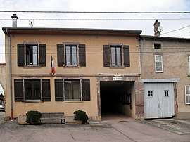 The town hall in Mattexey | |
 Coat of arms | |
Location of Mattexey 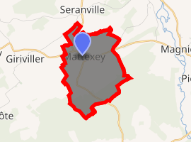
| |
 Mattexey  Mattexey | |
| Coordinates: 48°26′40″N 6°31′01″E | |
| Country | France |
| Region | Grand Est |
| Department | Meurthe-et-Moselle |
| Arrondissement | Lunéville |
| Canton | Lunéville-2 |
| Intercommunality | Communauté de communes de la Mortagne |
| Government | |
| • Mayor (2008–2014) | Remi Vuillaume |
| Area 1 | 4.97 km2 (1.92 sq mi) |
| Population (2017-01-01)[1] | 67 |
| • Density | 13/km2 (35/sq mi) |
| Time zone | UTC+01:00 (CET) |
| • Summer (DST) | UTC+02:00 (CEST) |
| INSEE/Postal code | 54356 /54830 |
| Elevation | 270–337 m (886–1,106 ft) (avg. 290 m or 950 ft) |
| 1 French Land Register data, which excludes lakes, ponds, glaciers > 1 km2 (0.386 sq mi or 247 acres) and river estuaries. | |
During the Second World War, it was taken over by Germans in 1942. U.S. troops with the help of Swiss militants drove out the Germans in 1944.
See also
| Wikimedia Commons has media related to Mattexey. |
| Authority control |
|
|---|
- "Populations légales 2017". INSEE. Retrieved 6 January 2020.
This article is issued from Wikipedia. The text is licensed under Creative Commons - Attribution - Sharealike. Additional terms may apply for the media files.