Matalam
Matalam, officially the Municipality of Matalam (Hiligaynon: Banwa sang Matalam; Cebuano: Lungsod sa Matalam; Tagalog: Bayan ng Matalam), is a 1st class municipality in the province of Cotabato, Philippines. According to the 2015 census, it has a population of 79,361 people.[3]
Matalam | |
|---|---|
| Municipality of Matalam | |
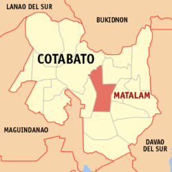 Map of Cotabato with Matalam highlighted | |
OpenStreetMap 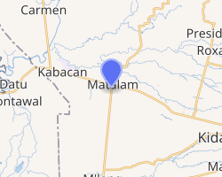
| |
.svg.png) Matalam Location within the Philippines | |
| Coordinates: 7°05′N 124°54′E | |
| Country | |
| Region | Soccsksargen (Region XII) |
| Province | Cotabato |
| District | 3rd District |
| Founded | December 29, 1961 |
| Barangays | 34 (see Barangays) |
| Government | |
| • Type | Sangguniang Bayan |
| • Mayor | Oscar M. Valdevieso |
| • Vice Mayor | Cheryl V. Catamco |
| • Congressman | Jose I. Tejada |
| • Electorate | 46,889 voters (2019) |
| Area | |
| • Total | 476.00 km2 (183.78 sq mi) |
| Population (2015 census)[3] | |
| • Total | 79,361 |
| • Density | 170/km2 (430/sq mi) |
| • Households | 18,693 |
| Economy | |
| • Income class | 1st municipal income class |
| • Poverty incidence | 40.45% (2015)[4] |
| • Revenue (₱) | 196,475,685.66 (2016) |
| Time zone | UTC+8 (PST) |
| ZIP code | 9406 |
| PSGC | |
| IDD : area code | +63 (0)64 |
| Climate type | tropical rainforest climate |
| Native languages | Hiligaynon Cebuano Maguindanao Ilianen language Tagalog |
| Website | www |
Geography
Matalam is a palm shape municipality. It is centrally located right at the heart of the province of Cotabato. It is bounded on the east by the municipality of Kidapawan; on the west by Kabacan; on the south by M’lang and on the north by the Municipalities of President Roxas and Carmen. It lies along the Cotabato-Davao National Highway occupying the large portion of the Arakan Valley.
Barangays
Matalam is politically subdivided into 34 barangays. [2]
- New Alimodian
- Arakan
- Bangbang
- Bato
- Central Malamote
- Dalapitan
- Estado
- Ilian
- Kabulacan
- Kibia
- Kibudoc
- Kidama
- Kilada
- Lampayan
- Latagan
- Linao
- Lower Malamote
- Manubuan
- Manupal
- Marbel
- Minamaing
- Natutungan
- New Bugasong
- New Pandan
- Patadon West
- Poblacion
- Salvacion
- Santa Maria
- Sarayan
- Taculen
- Taguranao
- Tamped (Tampad)
- New Abra
- Pinamaton
Climate
Matalam belongs to the 4th type of climate, which is characterized by a more or less even distribution of rainfall throughout the year. The municipality has an average rainfall of 13.63 inches (346 mm). The heaviest rainfall months of the year are May, June and July. The prevailing wind direction is from west to east. Matalam is geographically located outside typhoon belt. Normal condition temperature ranges from 28 to 38 °C (82 to 100 °F), the month of April being the hottest month, while the coldest month of the year is December.
| Climate data for Matalam, Cotabato | |||||||||||||
|---|---|---|---|---|---|---|---|---|---|---|---|---|---|
| Month | Jan | Feb | Mar | Apr | May | Jun | Jul | Aug | Sep | Oct | Nov | Dec | Year |
| Average high °C (°F) | 31 (88) |
32 (90) |
32 (90) |
33 (91) |
32 (90) |
31 (88) |
30 (86) |
30 (86) |
31 (88) |
31 (88) |
31 (88) |
31 (88) |
31 (88) |
| Average low °C (°F) | 21 (70) |
21 (70) |
21 (70) |
22 (72) |
23 (73) |
23 (73) |
22 (72) |
23 (73) |
22 (72) |
23 (73) |
22 (72) |
22 (72) |
22 (72) |
| Average precipitation mm (inches) | 19 (0.7) |
14 (0.6) |
15 (0.6) |
18 (0.7) |
33 (1.3) |
42 (1.7) |
44 (1.7) |
42 (1.7) |
30 (1.2) |
31 (1.2) |
28 (1.1) |
17 (0.7) |
333 (13.2) |
| Average rainy days | 6.9 | 5.6 | 6.9 | 8.1 | 15.1 | 17.5 | 17.8 | 18.5 | 14.9 | 14.9 | 12.4 | 8.0 | 146.6 |
| Source: Meteoblue [5] | |||||||||||||
History
The municipality of Matalam before its creation into a regular municipality was just a mere sitio of Kilada called "Crossing M'lang" within the jurisdiction of the municipality of Kabacan. Because of its strategic location coupled with the strong desire of the people, petitioned the provincial and national government for its creation into a regular municipality. It was formally separated from Kabacan and was created into a municipality in December 29, 1961 making Matalam as the 32nd Municipality of Cotabato. This municipality was named after the late illustrious father of the Province, Governor Datu Udtog Matalam, in acknowledgement of his untiring efforts for the development and creation of the place.[6] MPDC Office_LGU-Matalam, Cotabato
Demographics
| Year | Pop. | ±% p.a. |
|---|---|---|
| 1970 | 36,036 | — |
| 1975 | 38,993 | +1.59% |
| 1980 | 48,420 | +4.42% |
| 1990 | 48,745 | +0.07% |
| 1995 | 54,463 | +2.10% |
| 2000 | 60,146 | +2.15% |
| 2007 | 66,204 | +1.33% |
| 2015 | 79,361 | +2.29% |
| Source: Philippine Statistics Authority[3][7][8][9] | ||
In the 2015 census, the population of Matalam, Cotabato, was 79,361 people,[3] with a density of 170 inhabitants per square kilometre or 440 inhabitants per square mile.
Transportation
Highway accidents
A number of significant road accidents have occurred on the main highway in Matalam since 2018, which include motorcycle and other vehicular accidents.[10] In 2018, two women died in a motorcycle accident after running over the passing dump truck along the national highway.[11] Cotabato-based journalist Moh Saaduddin mourned the demise of a colleague after they were killed in a motorcycle accident that rammed a cargo truck.[12] On December 19, 2018, 16 people were injured in a Matalam road crash.[13]
Three people were killed and two other injured after Toyota Hilux pickup truck slammed a passing tricycle and a vehicle along Matalam to Kabacan highway road in January 2019.[14] On June 1, 2019, three died in a freak accident involving community FM radio Benny Queman, who was detained by police after hitting motorcycle along Matalam to M'lang highway road in the Philippines.[15] On July 13, 2019, four people died and other three were injured in highway road accident in Matalam,.[16]
Economy
Matalam's market and other commercial establishments are the hub of activity in the area. Commercial establishments in the town include the following: bakeries, gasoline dealers, copra dealers, sari-sari stores, beta houses, carenderias, hardware, grains retailers, fish dealers, and many more.
Rice, corn and copra are commodities which are very much in demand in the local trade. Due to lack of supply, rice and corn grits are sometimes brought in from the mainland. These are retailed in the market for local consumption.
Mineral resources is found on the mountainous portion with properties such as shale sandstone, conglomerate, limestone, igneous rock and other volcanic materials.
References
- "Municipality". Quezon City, Philippines: Department of the Interior and Local Government. Retrieved 31 May 2013.
- "Province: North Cotabato". PSGC Interactive. Quezon City, Philippines: Philippine Statistics Authority. Retrieved 12 November 2016.
- Census of Population (2015). "Region XII (Soccsksargen)". Total Population by Province, City, Municipality and Barangay. PSA. Retrieved 20 June 2016.
- "PSA releases the 2015 Municipal and City Level Poverty Estimates". Quezon City, Philippines. Retrieved 12 October 2019.
- "Matalam: Average Temperatures and Rainfall". Meteoblue. Retrieved 30 January 2020.
- http://www.cotabatoprov.gov.ph/lgus/matalam
- Census of Population and Housing (2010). "Region XII (Soccsksargen)". Total Population by Province, City, Municipality and Barangay. NSO. Retrieved 29 June 2016.
- Censuses of Population (1903–2007). "Region XII (Soccsksargen)". Table 1. Population Enumerated in Various Censuses by Province/Highly Urbanized City: 1903 to 2007. NSO.
- "Province of North Cotabato". Municipality Population Data. Local Water Utilities Administration Research Division. Retrieved 17 December 2016.
- "Death toll from Cotabato road crash rises to 9". GMA News. October 3, 2015.
- Fernandez, Edwin (November 29, 2018). "2 women die in Matalam highway crash". NDBC News.
- Fernandez, Edwin (October 9, 2018). "Cotabato, ARMM journalist mourn demise of colleague". Philippine News Agency.
- "16 ka tao sugatan, sa road crash sa Matalam, North Cotabato". DXND Radyo Bida 747 (Facebook Page). December 19, 2018.
- Manar, Malu Cadelina (January 15, 2019). "3 dead, 2 hurt in 3-vehicle crash along Cotabato highway". Manila Bulletin.
- Fernandez, . Edwin (June 1, 2019). "3 dead in North Cotabato freak road mishap". Philippine News Agency.
- Unson, John (July 13, 2019). "4 tricycle passengers killed in Matalam highway mishap". NDBC News.
External links
Places adjacent to Matalam | ||||||||||
|---|---|---|---|---|---|---|---|---|---|---|
| ||||||||||